NOAA
If you’re in the Dallas/Fort Worth region of North Texas, then you’re no doubt concerned about severe weather and the possibility of tornadoes. Here are some live radar streams along with where you can stay updated on tornado information.
Live Radars & Streams in the DFW Area & Throughout Texas
There are multiple live radars and live streams you can watch for updates on the storm, including in the DFW region. Here’s a look at some of them. Live streams might go down periodically, and we will try to find new ones if they do.
First is one from the Texas News Studio YouTube channel covering the severe weather in general, including live radards.
This next stream shows live radar of the storm’s progression, along with coverage from NOAA Weather Radio.
And here is a stream from NorthTxWildlifeCam, which shows their wildlife cams in Jack County, Texas, along with a constant live radar stream.
Texas Storm Chasers has a free, live interactive radar that you can watch here. This is a full map showing Austin, Dallas, and other areas across the state.
Here are some more live stream videos. This one is provided by Severe Weather Live.
And here is a video from Texas Storm Chasers. Their next update will be at 5 p.m.
Although not focused on the DFW area, a stream from Central Texas is below.
According to Texas Storm Chasers, the first tornado watch of the day in Texas was issued for most of the north Texas region, including Sherman, DFW, Waco, Killeen, Palestine, Greenville, and Paris until 9 p.m. Central. More watches are expected to be issued as the day progresses.
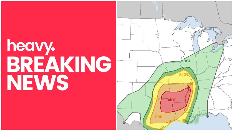
NOAA noted at 2 p.m.: “Widespread severe thunderstorms are likely across the southern Great Plains, mainly this afternoon and evening, spreading east into the
Lower Mississippi Valley tonight. The most dangerous corridor for strong tornadoes and intense damaging winds should be centered on northeast Texas through northern Louisiana and southern Arkansas this evening through the overnight…
By late afternoon, a line of intense storms should develop from northeast into east-central TX. These storms will track eastward into a progressively more sheared and moist environment. Large hail will be the primary threat initially, but storms will quickly evolve into bowing structures with increasing risks of widespread damaging winds and a few tornadoes through the night. Forecast soundings show minimal cap ahead of the line, along with intense low-level shear and ample boundary layer moisture. This suggests the potential for a few discrete storms to form ahead of the squall line as it moves across parts of AR/LA overnight. These storms would have the most prominent threat of strong tornadoes. 12z guidance is consistent in timing the squall line into western MS and southwest TN before Sat/12z, with a continued damaging wind and tornado threat.”
Widespread severe thunderstorms are likely across parts of the South-Central States, this afternoon through tonight. The most dangerous corridor for strong tornadoes and intense damaging winds should be centered on northeast TX, northern LA, and southern AR late tonight.

Sources for Updates & Additional Radars from DFW
If you’re looking for good sources for updates on DFW weather, one is Texas Storm Chasers. Their Facebook is here. A dashboard showing rapid-fire updates from all their social media sources is here.
The National Weather Service is another good source to follow. Their Twitter account is here. NWS for San Antonio/Austin is on Twitter here. And NWS for Fort Worth is here.
Steve McCauley is another great resource to follow on Facebook if you are in the Dallas region.
In Ellis County of the Dallas region, Ellis County Weather is a good resource to follow. They will broadcast on Facebook if severe weather becomes imminent.