The year 2015 will go down as the warmest for the globe in 135 years of records.
That's only one strange thing about 2015's weather.
From floods in some of the world's driest places to shocking warmth on the least-populated continent to a strange superposition of weather phenomena on a holiday, there was plenty in 2015 that made meteorologists scratch their heads.
A tornado spins in the Texas panhandle between the towns of Groom, Pampa, and Codman on November 16, 2015.
(Roger Hill, Silver Lining Tours)
Strong tornadoes are a common sight in the southern and central High Plains. But not in November.
On November 16, a trio of EF3 tornadoes tore through parts of the Texas panhandle and far southwest Kansas, part of a multi-day outbreak of an estimated 53 tornadoes from the Plains to the Southeast through November 18, according to severe weather expert, Dr. Greg Forbes.
These were the farthest west F/EF3 November tornadoes on record in the U.S., dating to 1950, according to NOAA's Storm Prediction Center (SPC) database, as plotted by the Tornado History Project.
The Texas panhandle EF3 tornadoes missed the town of Pampa, Texas, but levelled a Halliburton plant outside of town. The third EF3 struck a farm house west of Kismet, Kansas.
May and June are typically the most active months for tornadoes in the High Plains from southwest Kansas to the Texas panhandle, according to SPC climatology.
If that wasn't enough, the Kismet, Kansas, EF3 tornado was also believed to be the widest documented November tornado of record, estimated at 1.136 miles wide, according to the Dodge City, Kansas, National Weather Service storm survey.
14) Death Valley Heat in Washington State
Locations on this map recorded their highest temperatures on record in the month of June. Most of these records were set June 28, 2015, though a few were set June 26 or 27.
You know it's hot when you're running neck and neck with America's hottest desert.
Arguably the worst summer weather anywhere in the U.S. could be found in the Northwest, where a pair of searing summer heat waves sent the mercury well into triple digits.
According to weather.com senior meteorologist Nick Wiltgen, there were two separate days in July in which at least one location in Washington State tied the nation's notorious heat capital, Death Valley, California.
On July 9, Ellensburg, Pasco and Oroville, Washington all tied Death Valley's 104-degree high.
Ten days later, Entiat, Washington, tied Death Valley reaching 107 degrees.
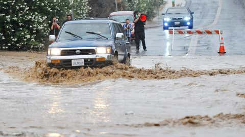
13) Two Dry-Season Soakings In Drought-Stricken Southern California
A vehicle drives through a flooded section of the road that was closed off on Pebble Beach Drive in Victorville, California, Sunday, July 19, 2015.
(David Pardo/The Victor Valley Daily Press via AP)
Southern California has distinct wet and dry seasons. In Los Angeles, 91 percent of the year's rain fell in the six-month period from November through April.
Given the exceptional drought, it only stood to reason once May came around that any hope of rain would evaporate until at least October or November, particularly in one of the nation's most consistently nice climates. But a bizarre 2015 had a pair of surprises.
A southward jet-stream plunge largely absent during the core winter months brought thunderstorms to Southern California, dumping 1.51 inches of rain in 90 minutes in San Diego, only their second one-inch-plus May rain of record.
Even more bizarre, a moisture surge triggered by Hurricane Dolores reached Southern California in mid-July, leading to what one National Weather Service meteorologist called "super historic" rainfall for that month.
The Tex Wash Bridge near Desert Center, California, was undermined by flood waters and collapsed in mid-July, prompting a closure of Interstate 10.
May's soaker prompted only the fifth rain delay at Petco Park, home of Major League Baseball's San Diego Padres since 2004. Then, mid-July's strange downpour lead to the team's first home rainout since April 4, 2006.
12) Back-to-Back Cyclones Slam Socotra Island
Cyclones Chapala (left) and Megh (right) threaten Socotra Island roughly one week apart in late October and early November 2015.
(NASA WorldView (compiled by Stu Ostro))
Tiny Socotra Island in the Arabian Sea just east of the Horn of Africa may have been the unluckiest place in the world in 2015, meteorologically speaking.
Incredibly one week later, Cyclone Megh made a direct hit on Socotra as a Category 2 or 3 storm, according to the India Meteorological Department.
While tropical cyclones in the Arabian Sea aren't unusual at all, this appears to have been the first time on record of back-to-back cyclones hitting Socotra in a week's time.
The WSU scientists said a dust storm the night before likely lofted dust from the lake, which later fell out in raindrops.
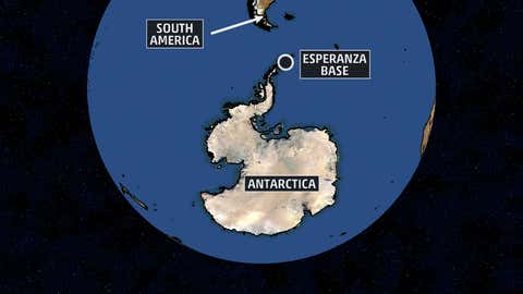
10) All-Time Record Heat in Antarctica
Location of Argentina's Esperanza Base.
Those are two words rarely joined together in any sentence.
On March 23, a weather station at Marambio Base on the Antarctic Peninsula recorded a high temperature of 63.3 degrees Fahrenheit. The following day, Esperanza Base, another station about 60 miles to the northeast, topped out at 63.5 degrees Fahrenheit.
These temperatures exceeded any previous record highs not only at those two locations, but anywhere else in Antarctica. For now, however, this potential continental temperature record remains unofficial, as Weather Underground's Christopher Burt details.
A snow gun sits idle at the Mount Sunapee Ski resort, Wednesday, Dec. 16, 2015, in Newbury, N.H. Unusually warm weather has ski areas closed with hopes of colder weather and snow soon. The Mount Sunapee Resort says it hasn't had one productive night of snowmaking since Nov. 30.
(AP Photo/Jim Cole)
December's warmth in the eastern two-thirds of the U.S. had many thinking of Halloween, not Christmas.
Through the first 16 days of the month, over 5,900 daily warm records (high temperatures and warm daily low temperatures) were either tied or broken in the U.S., compared to just 219 such daily cold records.
Weather Underground weather historian Christopher Burt noted Fentress Naval Air Base in Chesapeake, Virginia, recorded a heat index of 82 degrees on December 14. Yes, we said "heat index" in mid-December, and we weren't talking about the southern hemisphere.
With these temperatures, what might have been snow fell as rain, and what snow was on the ground melted quickly.
Some typically snowy northern New England ski resorts were forced to suspend operations. Mt. Mansfield, Vermont, tied its record lowest December snow depth on December 16, when only 1 inch blanketed the ground.
Speaking of the Badger State, a record high was set for any December or January game at Lambeau Field dating to 1959 when the Green Bay Packers hosted the Dallas Cowboys with a kickoff temperature of 53 degrees on December 13.
This icy imprint was left standing even after a Jeep pulled away from this parking lot in Greenville, North Carolina on February 17, 2015.
(Facebook/Trista Stiles)
February was brutally cold in most of the East. Other than New England's giant snow piles, an icy photo from North Carolina may have been most emblematic of that month's misery.
Following a period of sleet and freezing rain, a Jeep didn't take its ice accumulation with it when pulling out of a Greenville, North Carolina, parking lot. It left it there.
7) Central Pacific Ocean's Hurricane Season of Record
2015 tropical cyclone tracks through December 2.
(NASA Earth Observatory)
Fueled by favorably low wind shear thanks to a strengthening El Niño and warm water, the north Pacific basin shattered numerous records for tropical cyclones in 2015.
Among the many notables was the central north Pacific basin, encompassing a swath of the ocean from the International Date Line to 140 degrees West longitude, including Hawaii.
Eight named storms formed in the central north Pacific. That may not sound like much, but it doubled the previous record of four such named storms in 1982, according to Colorado State University tropical meteorologist, Dr. Phil Klotzbach.
Another six storms migrated westward into the basin from the eastern Pacific Ocean. Fortunately, the Hawaiian Islands dodged a landfall, as this amazing satellite collage shows.
Klotzbach says records for major (Category 3 or stronger on the Saffir-Simpson hurricane wind scale) tropical cyclones (31) and Category 4 to 5 storms (26) were shattered in the northern Hemisphere, which takes into account the entire north Pacific, north Atlantic and north Indian Ocean basins.
A fog bank near the beach at Sea Girt, New Jersey, on May 31, 2015.
(Captain Jim Freda, Beach Manager for Borough of Sea Girt, New Jersey)
If you planned a day at the beach along the southern New Jersey shore on May 31, you probably caught a sight few ever see.
We couldn't blame you if the first sight of this fog bank made you think of the Japanese tsunami of 2011. In this case, this "wave of fog" was simply caused by warm air condensing over the cold ocean waters.
The clear area above the fog was thanks to a sea-breeze front which had previously pushed well inland, dissipating clouds above it, according to the National Weather Service.
(Left) Ronald Gertson, a fourth generation rice farmer, shows where the level of water should be on a measuring stick in an irrigation canal as he deals with trying to grow rice during the severe drought on March 12, 2014 in Lissie, Texas. (Right) Water flows over the spillway from Lake Houston into the San Jacinto River Saturday, May 30, 2015, in Houston.
(Joe Raedle - Getty Images/AP Photo - David J. Phillip)
In September 2013, we wrote a piece highlighting the most stunning drought-to-flood shifts. What happened in 2015 in the Southern Plains blew any of those previous examples away.
In roughly six months' time, swaths of Texas and Oklahoma went from a long-term drought to massive flooding to a late-summer flash drought, then to more torrential fall rain.
As spring 2015 officially arrived, a swath from central Texas to western and northern Oklahoma and the Texas panhandle was still mired in extreme drought, which had been in place in some areas since late 2010.
Then a combination of record May rain, followed by Tropical Storm Bill in mid-June turned a drought into widespread flash flooding and river flooding in one of the sharpest drought-to-flood shifts imaginable.
Finally in late October, multiple rounds of torrential rain, some of which were fueled by the remnant moisture of Hurricane Patricia, hammered central and east Texas, as well as parts of Arkansas, Louisiana and Mississippi.
Over 25 inches of rain soaked Corsicana, Texas, in October. Austin saw its heaviest calendar-day rain in 94 years. A second flood swamped parts of San Marcos, Texas.
January through November 2015 was the wettest first 11 months of any year on record in Oklahoma, and second wettest in Texas, according to NOAA's National Centers for Environmental Information.
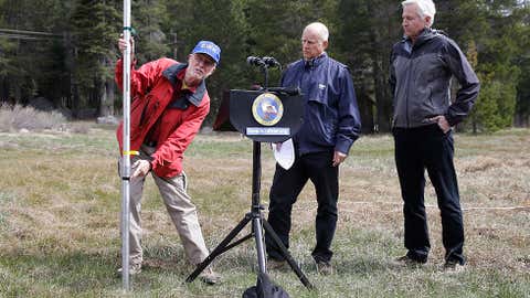
4) Sierra Snow Survey Finds No Snow
Frank Gehrke, left, chief of the California Cooperative Snow Surveys Program for the Department of Water Resources, points to a mark on the snowpack measuring pole that was the lowest previous snowpack level as Gov. Jerry Brown, center and Mark Cowin, director of the Department of Water Resources look on at a news conference near Echo Summit, Calif., Wednesday, April 1, 2015.
(AP Photo/Rich Pedroncelli)
If photos of low reservoirs weren't attention grabbing enough, perhaps the most bizarre sight during the worsening California water crisis took place on April Fools' Day 2015.
Each April 1, the California Department of Water Resources conducts a statewide snow survey, including manual measurements of the Sierra snowpack in several locations. Roughly one-third of California's drinking water comes from the Sierra snowpack, which after melting later in the spring and summer replenishes the state's reservoirs.
For the first time, the spring 2015 snow survey and news conference near Echo Summit was conducted on bare grass. Cooperative Snow Surveys Program chief Frank Gehrke could only point to the height on a measuring pole that was the previous record low snowpack there.
Statewide, the snowpack was only 5 percent of the April 1 average, by far the lowest on record for that date.
During that news conference, Gov. Jerry Brown announced mandatory statewide water restrictions for the first time in state history.
3) Record-Smashing Category 5 Hurricane Makes Landfall, Without Fatalities
Infrared image of Hurricane Patricia near peak intensity from NASA and NOAA's Suomi NPP satellite on Oct. 23, 2015 at 5:23 a.m. EDT.
(NRL/NASA/NOAA)
Just four days after the 10-year anniversary of Hurricane Wilma's record low Atlantic pressure measurement, Hurricane Patricia bested that record off the Mexican Pacific Coast.
On October 23, reconnaissance aircraft found Patricia's central pressure dipped to 879 millibars, with maximum sustained winds of 200 mph, the most powerful hurricane of record anywhere in the Western Hemisphere.
That, in itself, is amazing. What followed was nothing short of miraculous.
Patricia held together as a Category 5 hurricane at landfall near the town of Cuixmala, Mexico that evening, with estimated winds of 165 mph. An October 1959 hurricane near Puerto Vallarta was the only other known Category 5 landfall on Mexico's Pacific Coast.
Given that, you would expect devastation and, sadly, many fatalities. Remember, Hurricane Katrina claimed an estimated 1,500 lives in Louisiana and Mississippi.
Incredibly, there were no known fatalities directly related to this Category 5 hurricane.
How was this possible? In a word, "luck."
"Patricia's small core struck a very sparsely populated part of the coastline, with only 28 people per square mile," said hurricane specialist for The Weather Channel, Michael Lowry in an internal email on October 25.
The landfall location was about 60 miles northwest of Manzanillo, Mexico, with an estimated population of about 161,000. At landfall, Patricia's hurricane-force wind field extended only out to about 35 miles from the center.
"Had the center jogged only 20-30 miles east, the core would've been over an area with 10 times the population density," said Lowry.
"Not to mention its small size and the steep ocean floor just offshore limited Patricia's storm surge. Generally, it's the storm surge that has the greatest potential for large loss of life."
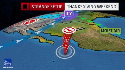
Hurricane Sandra and the Plains ice storm (Winter Storm Cara) on Thanksgiving weekend 2015.
It may sound ridiculous for an ice storm and a hurricane to be on a weather map at one time.
Yet that's exactly what happened during the Thanksgiving holiday weekend.
First, Hurricane Sandra was one of the latest-in-season eastern Pacific hurricanes on record. Sandra never made landfall, shearing out to a remnant low southeast of Los Cabos, Mexico.
Just about 400 miles to the northeast, Winter Storm Cara, produced sleet and freezing rain as far south as eastern New Mexico and West Texas, a tad earlier than average for an ice event in the U.S.
While Sandra did not cause the freezing rain/sleet event in the Plains states, but was, nonetheless, two components to a bizarre holiday weekend weather potpourri.
A man clings to a security line to cross a street flooded by the overflowing of the Copiapo River due to heavy rainfall that affected some areas in the city, in Copiapo, Chile on March 26, 2015.
(STR/AFP/Getty Images)
Imagine seeing over 14 years' worth of rain in 24 hours.
Chile's Atacama Desert is one of the world's driest places. The port city of Antofagasta picks up a mere 0.07 inches of rain a year. Compare that to Death Valley's 2.36-inch annual average precipitation.
In late March, Antofagasta picked up almost an inch of rain in 24 hours -- 0.96 inches, to be precise.
While this may not sound like much, as senior digital meteorologist Nick Wiltgen notes, "Without soil and plant cover to help absorb rainfall, it just runs off instantly as torrents of water."
Unfortunately, this proved deadly.
The torrential rain flooded the Copiapo River, claiming at least nine lives. Chile's Deputy Interior Minister Mahmud Aleuy called the flooding "the worst rain disaster to fall on the north in 80 years."
This event occurred at the same time the Antarctic peninsula was setting record warmth, mentioned earlier. This was no coincidence, according to Stu Ostro, senior meteorologist at The Weather Channel.
"That extreme rainfall in South America wasn't just from an isolated thunderstorm ... it was with a larger-scale pattern, they key being a very strong ridge of high pressure aloft, as has been the case with so many precipitation and temperature extremes in recent years," said Ostro in an internal email.
"This may be the most extraordinary one so far, given that it involves both one of the world's driest locations and the coldest continent, and at the same time no less, in the Southern Hemisphere."
MORE ON WEATHER.COM: Best Photos of 2015
1/124
A man rows a boat on the West Lake in the snow on Dec. 5, 2015 in Hangzhou, Zhejiang Province of China. (ChinaFotoPress via Getty Images)
Your local forecast, plus daily trivia, stunning photos and our meteorologists’ top picks. All in one place, every weekday morning.
By signing up, you're opting in to receive the Morning Brief email newsletter. To manager your data, visit Data Rights. Terms of Use | Privacy Policy
Advertisement
Your Privacy
To personalize your product experience, we collect data from your device. We also may use or disclose to specific data vendors your precise geolocation data to provide the Services. To learn more please refer to our Privacy Policy.