Thunderstorms are common not just in the United States, but indeed worldwide.
In fact, the National Severe Storms Laboratory states that there are an estimated 2,000 thunderstorms in progress at any given moment throughout the globe. In the U.S., approximately 100,000 thunderstorms occur annually, but only about 10% of these storms are categorized as severe.
What makes a storm severe?

When meteorologists talk about “bad” storms, what they’re referring to are storms that meet severe limits. So when you wonder if “it’s going to get bad”, listen for messaging that refers to severe thunderstorms.
What is a severe thunderstorm? Contrary to popular thought, the amount of lightning within a storm does not define its severity. Instead, a storm is considered “severe” if it produces any of the following:
- Wind gusts 50 knots (58 mph) or greater
- Hail that is 1 inch in diameter (approximately the size of a U.S. quarter)
- Tornado(es)
What are the main threats from severe storms?
Lightning: While the presence of lightning does not make a storm severe, it is still a formidable weather hazard. Lightning kills dozens of people each year, with dozens more surviving with lasting injuries.

Wind Damage: High winds are also a threat of severe thunderstorms. Wind speeds of 58 mph or greater have the power to uproot trees, down power lines, and cause structural damage to homes as well as buildings.
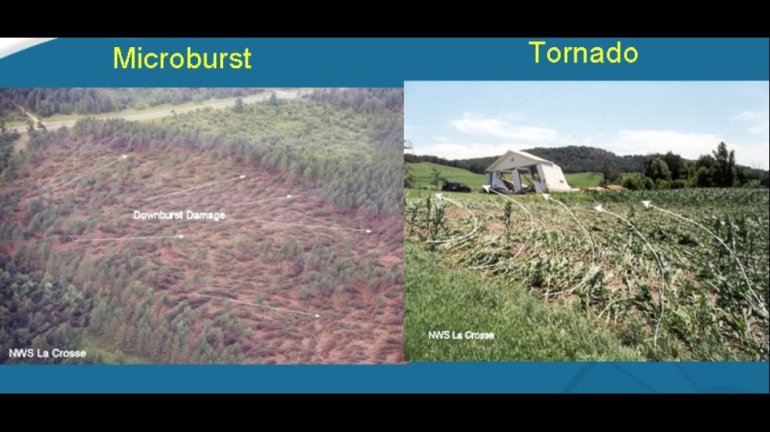
Often, high winds within a severe thunderstorm are due to downbursts, which are rapidly-moving downward columns of rain-cooled air.
Downbursts can cause considerable straight-line damage, similar to tornado damage with the exception that the winds fan outward in a straight line as opposed to swirling into a central vortex, as is the case with tornadoes.
Downbursts that are less than 2.5 miles in diameter are considered microbursts. Downbursts that are greater than 2.5 miles in diameter are considered macrobursts.
Hail
Hail occurs when water droplets within a thunderstorm rise high into the cloud, freeze, and then fall back towards the ground. As the frozen water particles fall, they partially melt as well as collide with other water droplets. As a result, an additional layer of liquid water accumulates on partially frozen water particle, and it grows bigger in size.
The water particle then gets lifted back into the top of the storm by the updraft, causing the water particle to refreeze. It falls, partially melts/collides with other water droplets, and continues to grow bigger in size.
The rising/freezing/falling/melting cycle continues until the hailstone grows in size to the point where it is too heavy to stay lofted in the updraft; it is then that it falls to the ground due to gravity, or due to negative buoyancy within the thunderstorm (ie, the air rushes to the ground as a downburst due to its cold, dense nature).
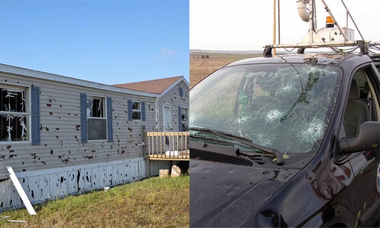
Hail is considered to be severe in size when it reaches a diameter of 1 inch or greater, which is similar in size to a U.S. quarter. It is at this size and beyond in which hail can cause damage to vehicle exteriors (particularly dent damage as well as punch holes into windshields). They can also injure people and pets stranded outside, and crops can be susceptible to hail damage.
If you ever see hail, be sure to note its size and compare it to a coin. Avoid comparing it to a marble, since marbles are sold in various sizes.
When estimating hail size, it is best to use common objects such as coins. pic.twitter.com/cCILnvV8JQ
— NWS Tallahassee (@NWSTallahassee) December 4, 2015
Severe thunderstorm safety: How to protect yourself during a severe thunderstorm
Severe thunderstorm alerts come in two forms: a severe thunderstorm WATCH and a severe thunderstorm WARNING.
A severe thunderstorm watch means that atmospheric conditions are favorable for severe thunderstorms to occur. Watches can be issued hours in advance of the anticipated severe weather, and they can span an entire state or region.
In contrast, a severe thunderstorm warning means that a severe thunderstorm is imminent or is already occurring. Warnings are issued when the National Weather Service detects a thunderstorm that is capable of producing either 58+ mph winds, large hail, or a tornado. Warnings can last anywhere from half an hour to just over an hour, and they usually span an entire county or two.
During a severe thunderstorm WATCH, be sure to monitor your weather radio or Live Alert 19 app for any changes in weather conditions. Gather your emergency kit and get ready to take action to head to safety; you should already have a place in mind to head to, and if not, determine where the closest shelter area would be located for your area.
During a severe thunderstorms WARNING, the time to act is NOW. If you are outdoors, head for a sturdy building immediately. If you are on the road, it would be a good idea to find a safe area to pull over and park throughout the duration of the storm, since visibilities would be greatly reduced due to the driving winds, heavy rain and potential hail threat.
If you are indoors during a severe thunderstorm WARNING, stay inside! Avoid being near windows and skylights since damaging winds or hail may shatter or break the glass and potentially injure you. Also avoid using wired electronics as well as the sinks or showers since the electrical current from a lightning strike may travel through the wiring of the house and plumbing on its way to your body, eventually delivering an electric shock.
If you see any thunderstorm damage due to high winds or hail, wait until the danger passes and then snap a picture through the Live Alert 19 app (you can also email us a photo@whnt.com). Please be sure to include your name and city/town/location. Your damage reports help ensure that forecasters at the National Weather Service as well as at WHNT News 19 provide the most detailed record of what occurred from the storms, which helps improve our forecasting abilities for future storms.