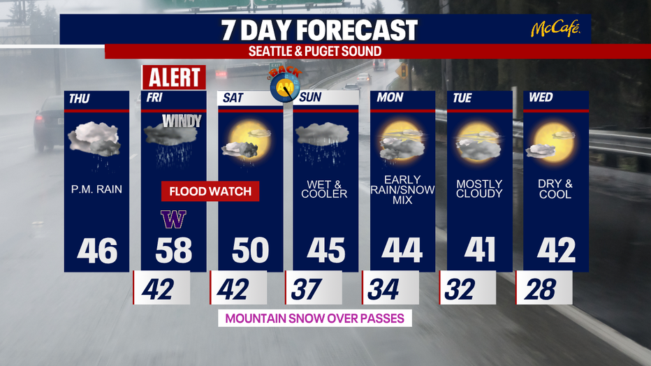
Seattle weather: Atmospheric river will bring heavy rain, flooding, strong wind Friday
SEATTLE - A strong atmospheric river will bring heavy rain, gusty winds, and the potential for flooding to the Cascades and Western Washington through Friday.
Here's a breakdown of the forecast:
Thursday
Precipitation will start in the afternoon as light to moderate, but it will be widespread. Areas around western King, Snohomish, and Pierce counties will at times be in the rain shadow of the Olympics and may see some dry times over the next 36 hours.
As soon as the precipitation reaches the mountains this afternoon, it will start off as snow. Models show 3 to 6 inches of snow could impact Snoqualmie, Stevens, and White passes before switching over to heavy rain before midnight. If your travels take you over the mountains during the evening commute or soon after, be prepared for winter driving.
The Washington Coast and areas north of Everett could see strong winds this evening, gusting to 50 mph.
GET THE FOX 13 WEATHER APP FOR SEVERE WEATHER ALERTS NEAR YOU
Friday
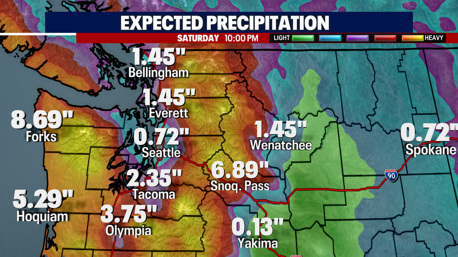
Early Friday, rain will pick up in intensity. The mountains and the Washington Coast will see especially heavy downpours with both areas expecting 4 to 6 inches of rain in total. In the Puget Sound area, the north sound and south sound will see the worst of the rain, with 1 to 3 inches of rain expected north and 1 to 4 inches expected south of Tacoma. The rain shadow may leave the greater Seattle area with just a half inch to an inch of rain through this storm.
Rivers will quickly rise as relentless heavy rain pounds the area through the afternoon and early evening. The Skokomish and Snoqualmie rivers are expected to crest late Friday or early Saturday in moderate flood stage, but that could change depending on the intensity of the rain. Urban flooding will also be an issue especially in areas with clogged storm drains.
Heavy rain will start to taper off into on and off showers as we get past dinnertime.
Wind will also be a factor for the Puget Sound area on Friday afternoon, with potential gusts in the 35 to 50 mph range. The wind will come at a time when the ground is saturated and may lead to scattered damage and power outages.
Saturday
This will be clean-up day as rivers and flood waters recede and winds die down. Snow levels will quickly plummet again early Saturday morning, so anything that falls Saturday and Sunday will be snow over the Cascade passes.
Looking ahead
Cool and showery weather returns heading into next week. Snow will accumulate at the Cascade passes starting Saturday and Sunday. The middle of next week looks dry, but chilly. High temps will only make it into the low 40s with overnight lows below freezing.