How much snow could Middle Tennessee see Friday?
After a warm and stormy Thursday that dropped hail across the region, Middle Tennessee residents woke up to light snow showers and flurries early Friday morning.
A cold front swept through Thursday evening, dropping temperatures roughly 30 degrees across the region. On-and-off light snow continued to move across the region as of 9:15 a.m. Friday, according to the National Weather Service Nashville.
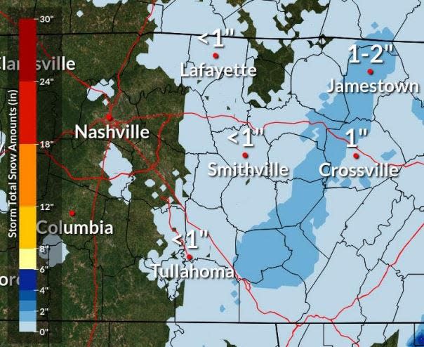
A light dusting of under an inch of snow is possible west of the Cumberland Plateau, but warm ground temperatures are curbing much beyond that, NWS said. That includes parts of Davidson, Williamson and Maury County.
"The vast majority of the area is not expected to see accumulation or impacts," NWS said in a Twitter post.
With the first *S* word gone, now for the second *S* word. It's not gonna be a ton, in fact, not everybody is gonna see it add up. Plateau should be the winner though with 1-3 inches thru tonight. Some slick driving possible by this afternoon and def tonight #tnwx #MiddleTN pic.twitter.com/00ZAO1lfUB
— NWS Nashville (@NWSNashville) January 13, 2023
Accumulations are expected mostly on or along the Cumberland Plateau. Higher elevations could see 1-3 inches, with locally higher amounts possible through Friday night. Slick roads may develop, especially into Friday afternoon and evening.
A winter weather advisory is in place until 6 a.m. Saturday for Cumberland, Fentress, Grundy, Overton, Pickett, Putnam, Van Buren, Warren and White counties.
Nashville-area radar
Nashville forecast for MLK weekend
Friday: Chances of snow showers and then flurries on-and-off all day. Cloudy. Chance of precipitation is 20%. High: 39; Low: 27
Saturday: Mostly sunny. High: 44; Low: 28
Sunday: Mostly sunny. High: 54; Low: 39
Monday (Martin Luther King Jr. Day): 50% chance of showers, increasing to 80% at night. High: 57; Low: 50
This article originally appeared on Nashville Tennessean: Nashville weather: How much snow is possible Friday in Middle TN
