5 things to know about the spring weather forecast in the US


 |
The annual explosion of cherry blossoms along the Tidal Basin frames the Washington Monument in the distance, Thursday, April 5, 2018, in Washington. (AP Photo/J. Scott Applewhite) |
Meteorological spring has arrived in the Northern Hemisphere, but AccuWeather meteorologists warn that it could still be a little too early to stash away snow shovels and heavy winter coats.
Millions across the eastern United States have already had a taste of spring with temperatures in February briefly reaching the 70-degree mark in New York City, Pittsburgh, Indianapolis and St. Louis. It may still be a while before the warmer weather is here to stay with more bouts of harsh cold and chances of snow expected in the coming weeks.
The official start of spring varies depending on who you ask. Forecasters base the seasons on the calendar with meteorological spring starting on March 1 and ending on May 31 every year. This is more consistent from year to year than astronomical spring, which starts on the March equinox and ends on the June solstice, two events that take place at different times every year.
No matter how you define it, AccuWeather has you covered with the top five things to know about the spring weather forecast across the U.S.
Spring is a turbulent time of year across North America in terms of weather, and at times, it will feel like the calendar has turned back to the winter months.
There will be fewer days that feel like spring during March compared to February across most of the East, AccuWeather Senior Meteorologist Paul Pastelok said. He added that the chilly weather pattern is likely to linger into April and include the potential for a visit from the polar vortex.
With ample cold air available, there will be more opportunities for snow.
 |
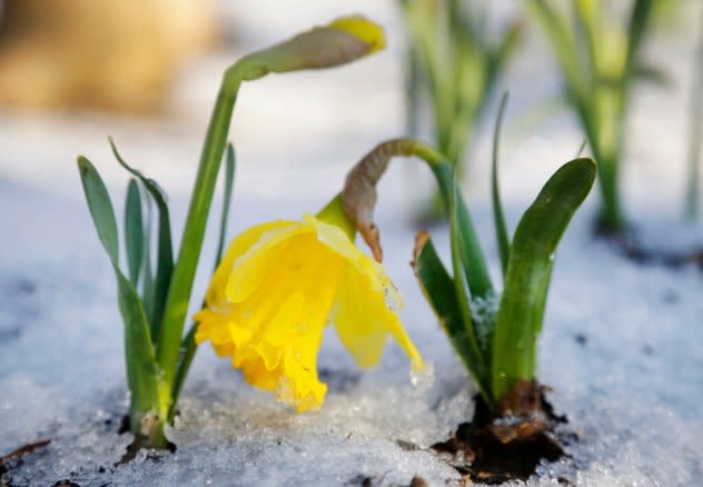
A daffodil is surrounded with snow, Wednesday, April 16, 2014, in the Brooklyn borough of New York. (AP Photo/Mark Lennihan) |
Most of the Northeast and Midwest have been experiencing a snow drought since late 2022 as seasonal amounts are well below the historical averages. The snow deficit in Cleveland is 32 inches below the historical average as of March 1. In Boston, the snowfall total is 28 inches below the historical average.
The least-snowiest season in Baltimore history was 1949-1950 when only 0.7 of an inch of snow accumulated. As of March 1, the city had measured just 0.2 of an inch, and if little to no snow falls there in March, April or May, the city could set a new record for the least-snowiest season in Baltimore history.
AccuWeather's team of long-range forecasters believes there could be accumulating snow in the Midwest and Northeast at times throughout the spring, including the chance of one big nor'easter or bomb cyclone. Snow chances will increase from the middle to the end of March and can continue into April.
"It only takes one storm" to drastically change the snowfall deficits across the Midwest and Northeast, Pastelok said. "Will [snow] get down to the East Coast? It gets harder in April and May, but still, it can happen. So, we still have a chance going [into spring]," he added.
Spring snow could be a late-season boon for ski resorts across the Northeast and Midwest that faced melting snow on the slopes during the warm spells in February.
Severe weather has been one of the biggest weather highlights of 2023 thus far, with the first month of the year having the second-highest tornado count of any January on record in the U.S.
The frequency of severe thunderstorms will continue to increase during the opening weeks of meteorological spring, endangering lives and property across large areas of the Central states.
"March can be active in Tornado Alley and parts of the Gulf States to the Ohio Valley for a time," Pastelok said.
 |
Neighbors look at damage to homes along Frost Lane on Monday, Feb. 27, 2023, in Norman, Okla. (AP Photo/Alonzo Adams) |
Pastelok cautioned there will likely be a midseason lull at the end of March and into April in which there could be fewer incidents of tornadoes and severe weather as colder air returns to the central U.S.
The pattern change will not completely eliminate the danger of damaging storms and will be followed by an uptick in severe weather in May.
Spring previews throughout February had people with green thumbs thinking ahead to the upcoming growing season, but AccuWeather forecasters warn that prospective planters should use caution this spring when starting an outdoor garden.
"There is a risk of a damaging frost and freeze in April," Pastelok warned, adding that frost could extend as far south as the Tennessee Valley and parts of the Southeast. "After all of the early warmth and growth in these areas, damage can occur to sensitive trees and plants in the region," he added.
 |
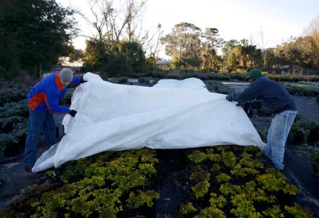
After an overnight freeze, nursery manager Rodney Rubright, left, and David Staats remove a cover to check on plants at the Spring Hill Nursery in Apopka, Fla., Thursday, Jan. 7, 2010. (AP Photo/John Raoux) |
The last frost of the season typically takes place around the start of April in the Southeast and Tennessee Valley, and around the start of May for most of the mid-Atlantic, Ohio Valley and southern New England, according to historical averages.
Anyone who does start an outdoor garden in April or early May should be prepared to take the proper precautions during late-season chills to protect young plants from the potentially damaging effect of frosts and freezes.
Extended spells of dry weather caused the water level on the Mississippi River to drop to near record-low levels last autumn, which forced barge traffic to be restricted, revealed artifacts that were submerged for over a century and allowed people to walk across the riverbed to islands that are usually surrounded by deep water.
Five months later, the same sections of the Mississippi River now face the risk of flooding.
"Frequent rainfall into March and April can lead to higher river levels and flooding from the Ohio River to parts of the mid- to lower Mississippi basin," Pastelok explained. March, in particular, is predicted to be very wet across most of the mid-Mississippi River Valley, the Tennessee Valley, the Ohio Valley and the Northeast.
The storm track responsible for the potential river flooding is likely to largely miss out on the High Plains, a region experiencing some of the worst short-term drought conditions across the country, according to the U.S. Drought Monitor.
 |
It's not just an active storm track that will help to fill rivers in the central and eastern U.S. A deep snowpack across the Upper Midwest and northern Plains will gradually feed into rivers as spring progresses, including the Red River along the border of North Dakota and Minnesota.
Farther west, melting snowpack across the Sierra Nevada can lead to flooding along streams and rivers flowing out of the mountains. The watersheds linked to the southern Sierra will be particularly vulnerable to flooding as the snowpack across this region of the mountain range is more than 200% of historical averages, and there is the potential for more storms throughout the spring.
Storms have bombarded the southwestern U.S. since the start of 2023, and while the frequency of storms is expected to decrease throughout March, the long-lasting effects of the frequent rain and heavy snow will be felt throughout the spring.
 |
Kenny Rybak, 31, shovels snow around his car in Running Springs, Calif., Tuesday, Feb. 28, 2023. (AP Photo/Jae C. Hong) |
In recent years when winters were drier than the historical averages due to a lack of storms, the following springs featured above-average temperatures as the energy from the sun directly heated the parched ground and the air. This year is a different story as many areas across the western U.S., especially California, have received an abundance of rain and snow. The energy from the sun will still warm the ground, but it also will work to evaporate some of the moisture-rich soil, resulting in lower temperatures.
AccuWeather long-range forecasters are predicting a cold March for storm-weary California and the majority of the western half of the United States. Temperatures during the first month of meteorological spring could average around 4 degrees below the historical average in Salt Lake City, Utah; Boise, Idaho; and Missoula, Montana.
 |
The abundance of moisture, the chance for a few springtime storms and cooler weather will help to delay the start of the upcoming wildfire season across the West.
Major improvements to the long-term drought are also expected in California, potentially eliminating drought conditions in some sections of the Golden State. The same cannot be said for the entirety of the West, with drought conditions likely to linger through the spring and into the summer.
Want next-level safety, ad-free? Unlock advanced, hyperlocal severe weather alerts when you subscribe to Premium+ on the AccuWeather app. AccuWeather Alerts™ are prompted by our expert meteorologists who monitor and analyze dangerous weather risks 24/7 to keep you and your family safer.
