NWS There was a tornado warning for Frederick, Maryland and other communities.
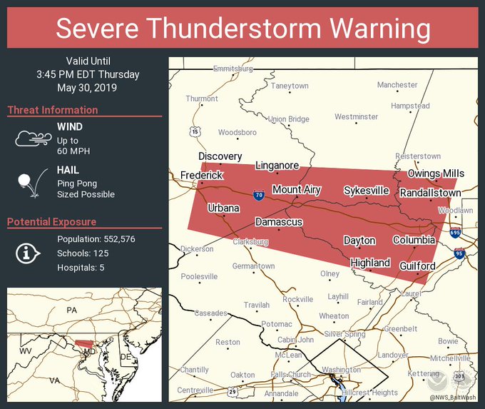
Frederick, Maryland and other neighboring communities were under a tornado warning on the afternoon of May 30, 2019 – through 3 p.m. After that expired, the National Weather Service wrote: “Severe Thunderstorm Warning including Columbia MD, Ellicott City MD, Frederick MD until 3:45 PM EDT.”
Severe Thunderstorm Warning including Columbia MD, Ellicott City MD, Frederick MD until 3:45 PM EDT
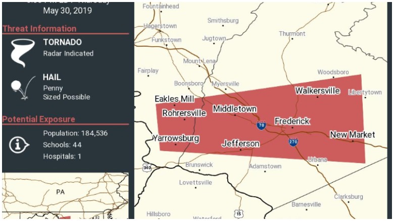
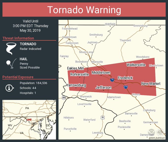
The National Weather Service earlier wrote: “Tornado Warning including Frederick MD, Walkersville MD, Middletown MD until 3:00 PM EDT.”
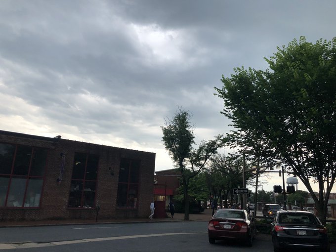
And the skies have opened up in Frederick! @wusa9 @MelissaNordWx @TenaciousTopper @hbwx @MiriWeather
The NWS also wrote: “Tornado Warning for…Southeastern Washington County in north central Maryland…Central Frederick County in north central Maryland…”
.@capitalweather hail in #UrbanaMD. That was wild! #frederickmd Aware of the tornado warning but not sure my son’s school is so I’m waiting to pick him up. Seems to be slowing now.
The NWS then provided an updated tornado warning that still included Frederick, writing, “Tornado Warning continues for Frederick MD, Braddock Heights MD, Jefferson MD until 3:00 PM EDT.” Track updated radar images for the area here.
Tornado Warning including Frederick MD, Walkersville MD, Middletown MD until 3:00 PM EDT
The tornado warning for Frederick and other communities in Maryland comes as the country reels from a series of tornadoes that caused damage in states ranging from Kansas to Oklahoma. For days, possible tornadoes have also imperiled areas along the east coast, including New York, New Jersey, and Pennsylvania.
TORNADO WARNING FOR FREDERICK! SEEK SHELTER NOW! #wusa9weather @wusa9 @hbwx @tenacioustopper @miriweather
Videos captured the bad weather.
People were urged to seek shelter. According to NWS, “At 224 PM EDT, a severe thunderstorm capable of producing a tornado was located near Boonsboro, or 8 miles east of Shepherdstown, moving east at 40 mph.”
In Frederick, MD, where the sky is looking ominous. Rain has started, and we just got an alert for a tornado warning. The @NWS says to take shelter now and estimates that it would move over this city around 2:45PM. @wusa9 @TenaciousTopper @MelissaNordWx @hbwx @MiriWeather
The weather service added:
“This dangerous storm will be near…
Braddock Heights around 235 PM EDT.
Ballenger Creek and Clover Hill around 240 PM EDT.
Frederick and Harry Grove Stadium around 245 PM EDT.
Walkersville, Linganore-Bartonsville and Discovery-Spring Garden
around 250 PM EDT.
New Market and Green Valley around 255 PM EDT.”
Tornado Warning Frederick MD! Seek shelter

The Baltimore/Washington D.C. office of the National Weather Service announced other weather watches and warnings for the area. “Severe Thunderstorm Warning including Centreville VA, Reston VA, Burke VA until 3:15 PM EDT,” the NWS wrote. “Severe Thunderstorm Warning including Warrenton VA, Marshall VA, Chester Gap VA until 3:30 PM EDT.” The tornado warning in Frederick was upgraded from an earlier severe thunderstorm warning.
You can track radar and updated weather forecasts and warnings for the area here.
The extended forecast for the region is as follows, per the National Weather Service:
“This Afternoon (May 30)
Showers likely and possibly a thunderstorm. Some of the storms could produce small hail and gusty winds. Mostly cloudy, with a high near 85. Southwest wind around 9 mph. Chance of precipitation is 70%. New rainfall amounts between a quarter and half of an inch possible.
Tonight
Showers and thunderstorms likely before midnight, then a slight chance of showers between midnight and 2am. Some of the storms could produce small hail and gusty winds. Mostly cloudy, with a low around 63. West wind 7 to 10 mph. Chance of precipitation is 60%. New precipitation amounts between a tenth and quarter of an inch, except higher amounts possible in thunderstorms.
Friday
Mostly sunny, with a high near 82. West wind around 6 mph.
Friday Night
Partly cloudy, with a low around 61. Northwest wind around 5 mph becoming calm in the evening.
Saturday
A chance of showers and thunderstorms after 2pm. Sunny, with a high near 84. Calm wind becoming west around 5 mph in the afternoon. Chance of precipitation is 30%.
Saturday Night
A chance of showers and thunderstorms before 2am, then a slight chance of showers. Mostly cloudy, with a low around 63. Chance of precipitation is 30%.
Sunday
Showers likely, with thunderstorms also possible after 2pm. Partly sunny, with a high near 79. Chance of precipitation is 60%.”