
Inciweb
Fires continue to burn in California, including a large fire near Murrieta that closed down schools and caused evacuations. Here’s a look at the latest wildfires being reported on September 5, 2019. This article first includes interactive maps for all of California, including Cal Fire and other sources. Then the second section details specific fires in the region in alphabetical order. Remember that when it comes to fires, details can change quickly, so also stay tuned to your local news sources if there is a fire in your region.
Interactive Maps of California Fires
There are two interactive maps to follow to get the best updates about California fires this summer. In many cases, the fires don’t always overlap so it’s good to review all the maps for the latest information.
One of the best interactive maps available right now is Inciweb’s map. You can see the full map here. There’s an embeddable Google Map that includes Inciweb fires which you can see below. Depending on your browser, you may need to zoom in using the + button within the map or change settings on the Layers tab of Legend to only show Inciweb fires:
Another good map can be found here from Ca.gov. A screenshot is below since the map can’t be embedded, but you’ll want to go to the full map for details. You can input your address to see how close the fires are to your location.

Cal.gov
Each of these maps often contains details the others are missing, so you’ll need to view all three for a full update on the fires. However, brand new fires may not be listed on any of the above maps until they’ve been around for a few hours. (Note: A previously helpful map was provided by CAL FIRE and Google. Unfortunately, this map hasn’t been updated in a while, so we’re no longer embedding the map in the story.)
A new interactive fire map is below, provided by UCANR.edu. Note that this map is only updated up to twice daily, so it may not be not as current as the two interactive maps above.
Next are more specific details on the fires for September 5, 2019. If you are looking for a specific fire such as the Tenaja Fire, search for the name so you can find it faster, or just scroll down and look at the fires, listed in alphabetical order.
List of Active Fires in California on September 5, 2019
Here are the active fires and updates about them. Most of these are in alphabetical order.
Broder Fire
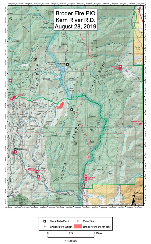
InciwebBroder Fire
This fire is 370 acres in size and 30 percent contained. It was started by lightning on August 8. It’s northeast of Broder Meadow and crews are using natural barriers to fight the fire, Inciweb noted.
Monache Meadows is open to recreationists, but use caution. The fire’s burning at a moderate rate of speed, Inciweb noted, and there may still be smoke in the region.
Country Fire
This fire is in El Dorado County, at Highway 193 and Penobscot Road east of Cool, according to Ca.gov. It’s 85 acres and 65 percent contained as of September 5. Four structures have been destroyed from this fire and there are two injuries.
#CountryFire
9/5/19
8:30 am
Great work done by fire crews on the Country Fire. The fire is at 65% containment. Full containment expected by tomorrow.
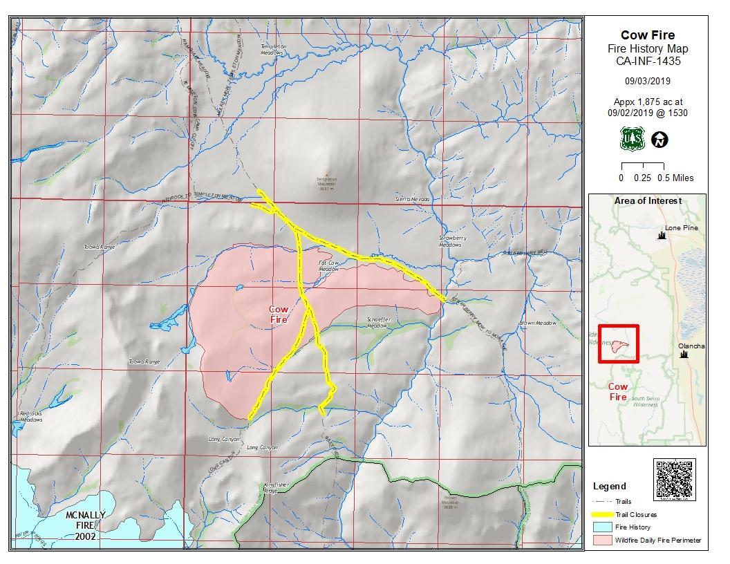
Cow Fire
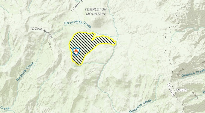
Inciweb
This fire is 1,975 acres in size and 30 percent contained, Inciweb noted. It was started by lightning on July 25 and is nearly 2,000 acres in size as of September 4. Planned actions include “to bring the fire from the west to the east along the north side of the fire. On the south side, continue to strengthen the trail and meadow natural barriers to keep pace with the interior burning.”
Inciweb
The fire’s burning in the Golden Trout Wilderness on Inyo National Forest. The fire’s being successfully confined and suppressed. Inciweb noted: “Fire managers anticipate the wildfire will continue to move naturally across the landscape at a low-intensity for a two more weeks.”
Deer Fire
Ca.gov
This fire is 10 acres and 80 percent contained, according to Ca.gov. It’s in Santa Cruz county northeast of Boulder Creek, near Deer Creek Road and Rons Road.
Forward spread has been stopped and road closures are lifted. The cause is under investigation.
Flood Fire
New Incident: #FloodFire near Flood Rd and N. Waverly Road, Southwest of Rancho Calaveras in San Joaquin County is 44 acres.

The Flood Fire is in San Joaquin County near Flood Road and N. Waverly Road. It’s southwest of Rancho Calaveras.
#FloodFire 🔥 unofficial, automated update.
~6mi ENE of Peters, CA. ⚠️ DO NOT USE FOR SAFETY PURPOSES – See officials instead. May be incorrect; disclaimers in images.
t.co/0vWYECD5nO
The fire is 44 acres in size.
Glass Fire
#GlassFire as seen from the Mt. Konocti Fire Camera (Lake County):
This fire is 20 acres and 80 percent contained as of September 5, according to Ca.gov. It’s in Lake County, southwest of Clear Lake, near Highway 29 and DNA Ridge Rock.
Highway 29 from Manning Flat to Point Lake View Drive is closed for the fire.
KNF Lighting (September 5, 2019)
Inciweb noted: “After a night of thunderstorms and lightning, the Klamath National Forest is responding to multiple lightning fires. We will post updates throughout the day as the storms are ongoing and conditions change.”
R-1 Ranch Fire
This fire is 3,380 acres and 98 percent contained, as of Inciweb’s last update on September 3. Crews are continuing to patrol the fire. Inciweb won’t be issuing any more updates unless things change. The fire is 13 miles north of Susanville along Horse Lake Road.
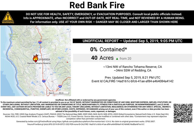
Red Bank Fire
AA110 overhead of the #RedBankFire in Tehama Co west of Red Bluff, reports 35-40 acres w/ moderate ROS pushing to the north, ordering 2 addl tankers closest for a total of 6 tankers. IC requesting 4 addl handcrews.
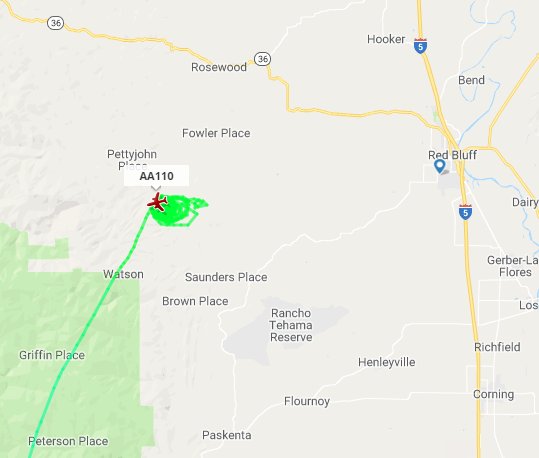
This fire is now 1,000 acres and 0 percent contained as of September 5. It was first discovered on the afternoon of September 5 in Tehama County, according to Ca.gov.
#RedBankFire 🔥 unofficial, automated update.
~13mi NW of Rancho Tehama Reserve, CA. ⚠️ DO NOT USE FOR SAFETY PURPOSES – See officials instead. May be incorrect; disclaimers in images.
t.co/M1h05yqho2

It’s west of Red Bluff, off Hammer Loop Road and Petty John Road.
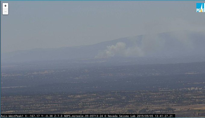
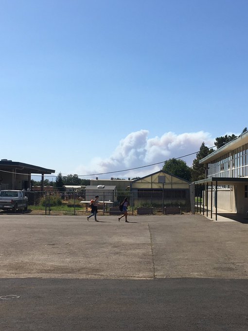
Here’s a quick look of #RedBankFire from Red Bluff High School. 330pm
The fire is 25 miles west of Red Bluff and is threatening cabins in the area as of 3:45 p.m. Pacific, Red Bluff Daily reported. It started out as a 10-acre vegetation fire and quickly grew.
Some mandatory evacuations were put in place for the fire. This has been reported by local news but is not yet listed on Ca.gov’s website.
Mandatory evacuations in Tehema Co. for the #RedBankFire. Shasta Trinity N.F. to Petty John. Evacuation advisory for R Wild Horse Ranch. Fire is spreading rapidly. I will have the latest for you in the morning. Until then, follow @ActionNewsNow and your local officials.
According to Action News Now, mandatory evacuations have been issued from the Shasta Trinity National Forest to Petty John. An evacuation advisory is in place for R Wild Horse Ranch (which means to be ready to evacuate at a moment’s notice.)
Follow Tehama County Deputy Sheriff’s Association’s Facebook page for updates.
SHF Lightning 2019
Here are the latest updates on lightning fires in the region of 41.063 latitude, -122.638 longitude, according to Inciweb. The list below is a direct quote from Inciweb’s page.
South Fork Management Unit (Hayfork and Platina area)
09/05/2019 7:11, LITTLE, Yolla Bolla Wilderness, 0.1 acre, Patrol status
09/05/2019 7:14, FORK, southwest of Platina west of Tedoc, 0.25 acre, staffed
09/05/2019 8:57, LOVE, north of Hayfork near Love Letter Springs, 0.25 acre, crews hiking in
09/05/2019 9:34, NATURAL, near Natural Bridge > CAL FIRE SHU direct protection area
Trinity River Management Unit (Weaverville, Big Bar, Trinity Lake, Trinity Alps)
09/05/2019 7:09, EAST, Halls Gulch NE of Trinity Lake, 0.25 acres
09/05/2019 7:22, LADY, Lady Gulch Trinity Alps Wilderness, 0.1 acres
09/05/2019 7:25, LICK, east of Trinity Lake
09/05/2019 7:28, NELSON, east of Trinity Lake
09/05/2019 8:16, CEMENT, east of Trinity Lake
09/05/2019 8:18, FOOL, west of Trinity Lake, 0.1 acres
09/05/2019 8:20, QUARTZ, west of Trinity Lake
09/05/2019 8:23, SLATE, west of Trinity Lake
09/05/2019 9:07, MIDDLE, NE of Canyon Creek Trailhead, 0.1 acres
09/05/2019 10:38, WAGNER, Billy’s Peak west of Trinity Lake, 0.1 acres
Shasta Lake Ranger District and the National Recreation Area (Shasta Lake)
No fires detected
Shasta McCloud Management Unit (Mt Shasta and McCloud area)
No fires detected
Springs Fire

Inciweb
This fire is now 4,840 acres and 75 percent contained, according to Inciweb on September 5, the latest update. It was caused by lightning. It’s located 13 miles southeast of Lee Vining.
Inciweb noted: “Low-intensity fires create fire resilient landscapes that are more sustainable. Healthy, fire-resilient forests are less prone to large devastating wildfires, promote wildlife habitat, and help fight invasive species.”
Inciweb also shared a special message on August 25 about the fire’s longevity.
When will the Springs Fire be put out? This question has been posed to fire managers since late July. Here we are in September and it is still burning. Some people want to know why. First, fire managers have many opportunities to contain the fire using roads and manage fire behavior in areas recently treated through prescribed fire and mechanical methods. Second, highly trained crews are available to carry out these objectives since they are not needed elsewhere at this time for fires that threaten higher values at risk (homes, etc.). Third, due to the weather and above average winter precipitation, fuel conditions (pine needles, shrubs) are nearly optimal to carry out precision ignition strategies… Fourth, expert smoke modelers are on staff and are accurately predicting how smoke produced from ignitions will disperse every day. They also advise if smoke from other fires in the area will combine to result in adverse air quality effects and, when to decrease smoke production due to ineffective smoke dispersal into the upper atmosphere.
So, how long will the Springs fire burn? The answer depends on all of the above conditions… For example: if all four of the above conditions are optimal, it will take less time; if conditions become less optimal, it will take more time, or managers stop actions and objectives will not be fully met.”
Telephone Fire
#TelephoneFire 🔥 unofficial, automated update.
Near Hesperia, CA. ⚠️ DO NOT USE FOR SAFETY PURPOSES – See officials instead. May be incorrect; disclaimers in images.
t.co/PjRsxx42kr
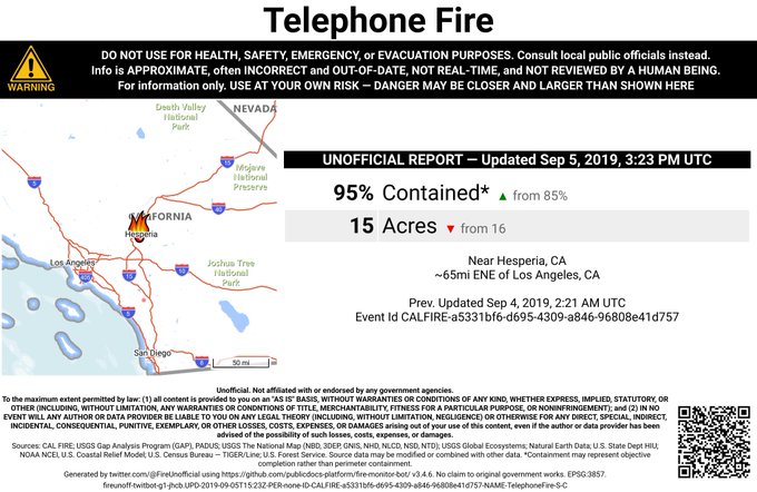

This fire is 15 acres and 95 percent contained, according to Ca.gov. It’s in San Bernardino County in Hesperia, near Old Dump Road, south of Summit Valley Road. Forward spread has been stopped and crews remain on the scene to mop up the fire. The cause is under investigation.
Tenaja Fire
The Tenaja Fire is listed on Ca.gov’s map but it’s not on Inciweb’s map yet, as of the time of publication. It’s 2,000 acres in size and 7 percent contained, according to CA.gov and Cal Fire.
#TenajaFire [UPDATE] – The fire is now 2,000 acres and 7% contained.
The fire started near Tenaja Road and Clinton Keith Road in La Cresta on the afternoon of September 4. Below is an approximate location for where the fire started. It does not indicate the fire’s size, which is nearly 2,000 acres as of the time of publication.
This next map shows the fire’s approximate location along with the locations of evacuation orders and care centers. This map is from The Press-Enterprise. You may need to zoom in, depending on your browser.
The fire started at 4:43 p.m. on September 4, according to the California Department of Forestry & Fire Protection, and then quickly grew in just a few hours to 994 acres in Riverside County. Now it’s 2,000 acres in size.
Here’s a map of evacuation orders that is being updated by the County of Riverside. Yellow indicates voluntary evacuations and red indicates mandatory evacuations. Each shaded area, if clicked on, will show where you should be evacuating to. You can enter your address on the map to see if you are under an evacuation order. Use the + icon to zoom into the map, which may be necessary depending on the browser you’re using.
You can visit the full-sized map here.
Here are the current evacuations as of September 5 at 3:50 p.m. Pacific.
- Evacuations have been ordered for all residences in The Trails Circle in La Cresta, Ca.gov noted on September 4.
- “Mandatory evacuations are now being issued to residents in Copper Canyon South of Calle del Oso Oro between Clinton Keith and Murrieta Creek,” as of 10 p.m. on September 4.
- New evacuations were ordered on September 5 for Montanya Place, Botanica Place, Belcara Place, and Lone Oak Way in the city of Murrieta. People in these areas must leave now.
CAL Fire’s Twitter account notes that a care and reception center is set up at Murrieta Mesa High School at 24801 Monroe Avenue, where small animals will also be accepted.
Large animals should be taken to the San Jacinto Animal Shelter at 581 S. Grand Avenue in San Jacinto, CAL Fire shared.
Small animals are being accepted at the care and reception center, located at Murrieta Mesa HS. Large Animals can be taken to the San Jacinto Animal Shelter 581 S. Grand Ave. San Jacinto, CA 92582 #TenajaFIRE
Evacuation warnings have been issued for Bear Creek and Copper Canyon areas of Murrieta, Patch.com reported. Evacuation warnings mean you should be prepared to leave with little notice.
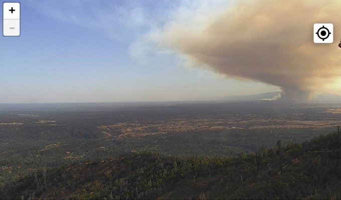
Vista Fire
Residents in the Mt. Shasta Vista subdivision were given a code red evacuation warning today for an area southeast of Montague but that evacuation has now been lifted, KDRV reported. The fire is 2 to 3 acres in size. Forward progress has been stopped.
Walker Fire
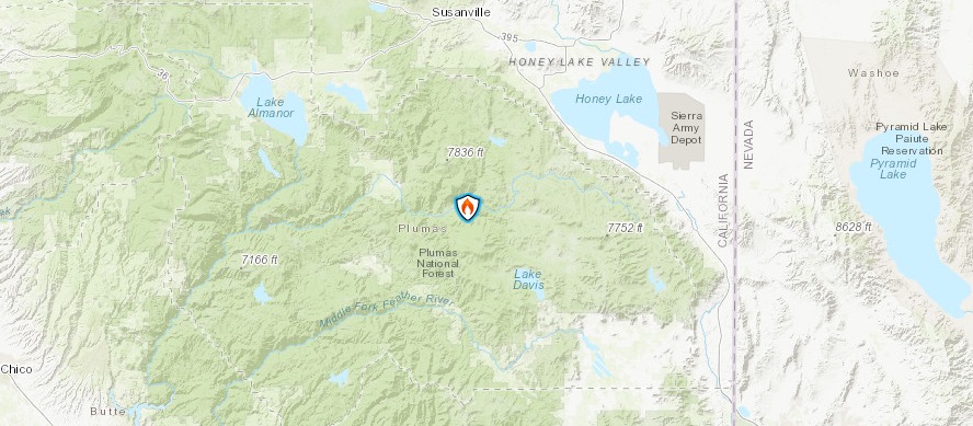
Inciweb
This fire is 850 acres and 5 percent contained as of September 5, according to Inciweb. It’s in Genesee Valley. It was first reported on September 4 and the cause isn’t known.
Inciweb noted: “Incident objectives include keeping the fire south of Beckwourth Genesee Road, north of Nye Creek Road, east of Genesee Valley Road and west of the Mt. Hough/Beckwourth Ranger District boundary. The Genesee Valley, and Antelope Lake Roads remain open but visitors & residents are advised to use them sparingly and to expect heavy fire traffic along the routes. The Beckwourth-Genesee Road is closed.”
READ NEXT: WATCH: Man with TV on Head Leaves CRT TVs on Porches in Virginia