Over 18,000 firefighters continue to battle 27 major fires in California, as "critical fire weather continues to fan multiple fast-moving major wildfires," according to the latest report Monday by the California Department of Forestry and Fire Protection (Cal Fire).
The Glass Fire in Napa and Sonoma counties has more than tripled since Monday morning, when it was reported to be at 11,000 acres.
The Glass Fire has since increased to over 36,000 acres.
The Zogg Fire in Shasta County has grown to over 31,000 acres, more than four times the 7,000 acres it was reported to have burned as of Sunday.
California Gov. Gavin Newsom declared a state of emergency Monday across Napa, Sonoma and Shasta counties due to the Glass and Zogg fires.
The governor also sent a letter to President Donald Trump "requesting a Presidential Major Disaster Declaration to assist state and local wildfire response and recovery efforts in the counties of Fresno, Los Angeles, Madera, Mendocino, San Bernardino, San Diego and Siskiyou," the governor's office confirmed in a statement Monday.
🚩𝐑𝐞𝐝 𝐅𝐥𝐚𝐠 𝐖𝐚𝐫𝐧𝐢𝐧𝐠🚩 remains in effect as critical fire weather conditions continue.
— NWS Sacramento (@NWSSacramento) September 28, 2020
Any new and/or existing fires will have the potential to rapidly grow as a result of the strong winds, low relative humidity values, & dry fuels. #CAwx #CAfire pic.twitter.com/ZHh4NBa9Ih
More than 8,100 wildfires have over 3.7 million acres of the state, with 26 people dead and over 7,000 structures destroyed since August 15, when California's fire activity increased, according to Cal Fire.
Here are updates on some of the latest major fires across the state.
🔥BLM Wildland Fire map for Sept. 28. This is a map of all active large fires within California and the BLM-managed acreage affected. For the latest fire info: https://t.co/p10omwOfww #FireYear2020 #CAWildfires #BEprepared pic.twitter.com/GbBwJWImki
— Bureau of Land Management California (@BLMca) September 28, 2020
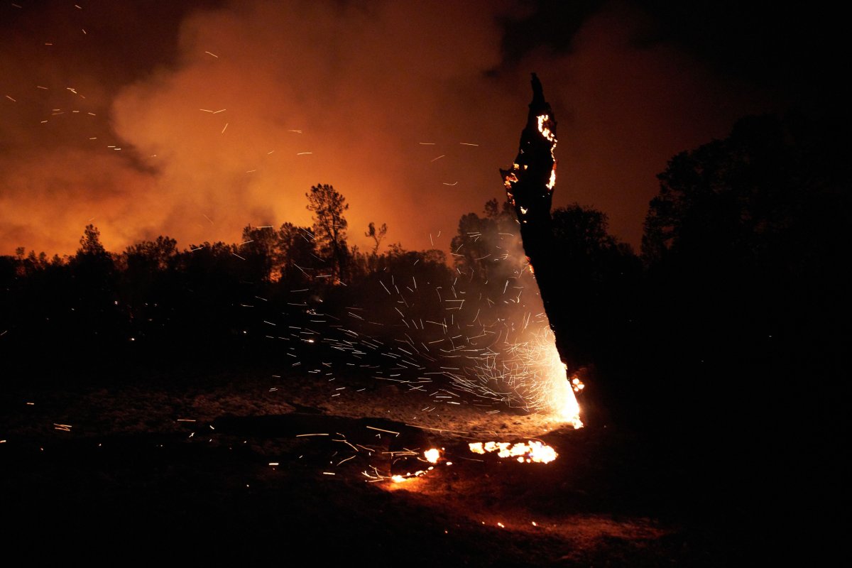
Glass Fire
- Location: Napa and Sonoma counties
- Acres: 36,236.
- Containment: 0 percent.
- Structures threatened: 8,543
The Glass Fire was reported to have a "dangerous rate of spread" and has expanded into Sonoma County. The two additional fires that sparked Sunday evening have merged with the Glass Fire, according to the latest report Monday by Cal Fire.
"Crews have reported the fire has had short-range spotting with wind driven runs. A red flag warning is in effect through today for strong and gusty offshore winds, low humidity, and dry fuels," the report said.
Evacuation orders remain in effect for parts of Napa and Sonoma counties as well as the cities of Santa Rosa and Calistoga. Road closures are also in place for Napa and Sonoma counties. See Cal Fire's full report for details.
9/28 3:55 pm (Español abajo) Fire Fatigue? This might be why.
— Sonoma Sheriff (@sonomasheriff) September 28, 2020
Here is a map showing our fire history over the last several years.
¿Fatiga de incendio? Esta podría ser la razón. Aquí hay un mapa que muestra nuestro historial de incendios durante los últimos años. #glassincident pic.twitter.com/rGY9zaNtL8
Zogg Fire
- Location: Shasta County.
- Acres: 31,237.
- Containment: 0 percent.
- Fatalities: 3.
- Structures threatened: over 1,500
Three deaths have been reported in connection with the Zogg Fire, Shasta County Sheriff Eric Magrini confirmed at a Monday press briefing, while 146 structures have been destroyed and over 1,500 structures remain under threat, as of 7 p.m. Monday.
Active fire behavior was reported Monday, with continued wind-driven runs as well as torching and spotting. The fire was expected to continue moving Monday, with short- to long-range spotting potential. Threats to the communities of Igo, Ono, Happy Valley, Platina and critical infrastructure in the area remain.
Evacuation orders and road closures are in place in multiple parts of Shasta County. See Cal Fire's full report for details.
#SATELLITE SPOTLIGHT: This animation from @NOAA's #GOES17🛰️ yesterday shows the #smoke and heat signatures from some of the active Calif. #wildfires, including the #RedSalmonComplex. Farther south, @CAL_FIRE said other fires are causing evacuations in #Napa and #Sonoma counties. pic.twitter.com/qDXzSU56KT
— NOAA Satellites - Public Affairs (@NOAASatellitePA) September 28, 2020
Bobcat Fire
- Location: Los Angeles County.
- Acres: 114,202
- Containment: 62 percent.
Fire activity in the Bobcat Fire was limited to "mainly smoldering and creeping where heat exists within containment lines," according to the latest report Tuesday from the Incident Information System of the National Wildfire Coordinating Group (NWCG).
The fire is projected to remain nearly within its existing footprint, with a couple of exceptions, including "one near Mount Lewis, where fire is backing, flanking and rolling out, with some flare ups," while the other exception "is northwest of Mount Wilson where interior island continues to consume, backing flanking, occasional flare ups/runs, and individual tree torching," the report noted.
A large area of high pressure will expand over the west, with "well above average temperatures and single digit humidity are expected over the next four days," and a heat advisory is in effect from 10 a.m. local time Tuesday through 8 p.m. local time Thursday over the Bobcat Fire, the NWCG noted.
The #BobcatFire is approximately 114,200 acres with 62% containment. There are currently 1,363 personnel assigned to the incident.#LACoFD pic.twitter.com/pisAZKpJHG
— L.A. County Fire Department (@LACoFDPIO) September 28, 2020
August Complex Fire
- Location: Mendocino, Humboldt, Del Norte, Trinity, Lake counties.
- Acres: 902,463.
- Containment: 45 percent.
- Structures threatened: 11,310
"The fire remains extremely active; winds are carrying embers well beyond containment lines, and there is high potential for the fire to develop an active plume," according to the latest report Monday by Cal Fire.
The West Zone of the fire has burned 111,165 acres, with 65 percent contained. The fire was reported to have been driven west on Monday, which prompted evacuation orders and warnings to be expanded in Trinity, Humboldt and Mendocino counties.
High winds were forecast throughout Monday, with gusts surpassing 30 mph and the potential to speed down the west slope of South Fork Mountain, threatening communities to the west and north. The Ruth Valley and Mad River Valley were aligned Monday "to funnel the forecast winds and encourage fire spread in these areas," the report added.
New evacuation orders have been issued for the Mad River, Lower Mad River Road, Zenia and Kettenpom areas.
New road closures are in effect for all roads in Van Duzen, Mad River, Ruth and the Hettenshaw areas, while Ruth Zenia Road is closed east of the US Forest Service Zenia Guard Station.
The closure for State Route 36 has been extended from the Humboldt County line on the west to the junction with Bowman Road on the east.
See Cal Fire's full report for details on all evacuations and road closures.
#UPDATE and map for the #AugustComplexSouthZone for 9/28
— Mendocino NF (@MendocinoNF) September 28, 2020
The South Zone is a part of the #AugustComplex also burning in the @SixRiversNF and @ShastaTrinityNF
For more info: https://t.co/O9NtrjgS2Y #FireYear2020 #wildfires2020 @CALFIRE_MEU pic.twitter.com/9zrJ6FFTXr
Creek Fire
- Location: Fresno and Madera counties.
- Acres: 304,640.
- Containment: 39 percent.
- Structures threatened: 4,576.
Fire activity in the North Zone was moderated by low humidity on Monday, with a slight progression of the fire towards the northeast near Cattle Mountain. "Fire activity will be present in Chetwood Creek, Norris Lake, East Fore Chiquito, and Northeast of Little Shuteye Peak, and south of Whisky Falls," Cal Fire noted in its latest report Monday.
The fire was reported to be more active in the South Zone, towards the 80 Road and Potter Pass. "As the fire continues to burn on the east side, the goal is to keep it north of Kaiser Pass. If the fire moves into sparser fuels progression will slow as it moves towards the Ansel Adams Wilderness," the report said.
Areas under evacuation warning and orders are being repopulated, while road closures remain in place for parts of Fresno and Madera counties. See Cal Fire's full report for details.
#CreekFire Progression Map for Monday, September 28th. #FireYear2020 pic.twitter.com/kjAsGYawmq
— Sierra Ntl. Forest (@Sierra_NF) September 28, 2020
Other fires
- North Complex Fire in Butte, Plumas, Yuba counties: 306,135 acres; 78 percent contained.
- Slater/Devil Fires in Siskiyou County: 154,102 acres; 40 percent contained.
- SQF Complex Fire in Tulare County: 150,744 acres; 54 percent contained.
- Red Salmon Complex Fire in Humboldt County: 116,819 acres; 31 percent contained.
For the latest up-to-date information on these fires and others in the state, visit the Cal Fire website.
Uncommon Knowledge
Newsweek is committed to challenging conventional wisdom and finding connections in the search for common ground.
Newsweek is committed to challenging conventional wisdom and finding connections in the search for common ground.
About the writer
Soo Kim is a Newsweek reporter based in London, U.K. She covers various lifestyle stories, specializing in travel and health.
Soo ... Read more
To read how Newsweek uses AI as a newsroom tool, Click here.