

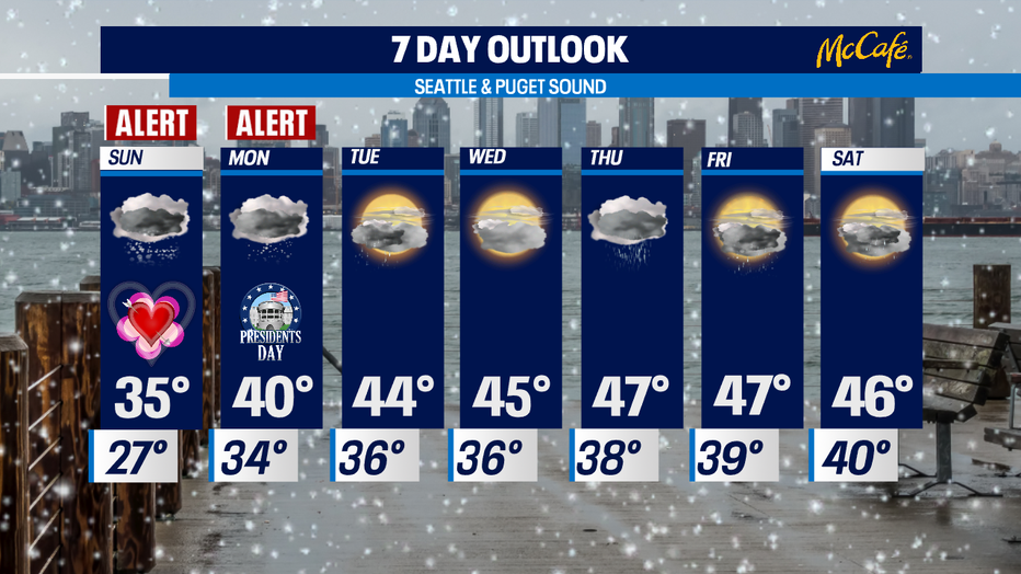
Snow returns Sunday, before switching to wintry mix/rain
SEATTLE - The next weateher system is arriving Sunday morning already and will come in quickly.
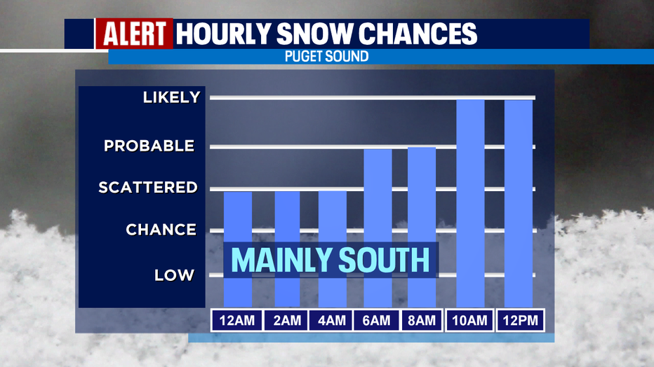
By Sunday morning most of us will be waking up to more snow showers. By later in the afternoon/early evening snow should turn to that wintry mix/rain.
Here's a breakdown of snow chances:
And by Monday morning we should see rain, but again the transition is sometimes tricky so don't be surprised as we warm if some areas see snow at times.
GET THE Q13 WEATHER APP TO TRACK SNOW IN YOUR NEIGHBORHOOD
We've issued "Weather Alert Days" through Monday morning.
As we jump into the work week ahead rain will return, and more traditional February weather will sit with us. If you're looking for a dry day, right now most of Wednesday is looking okay. By late evening into the overnight hours, showers will return for a sloppy Thursday.
RELATED: Snow, slick roads causes road closures across Western Washington this weekend
The weekend will feature mostly cloudy skies with a chance of showers each day. Highs fight their way back into the upper 40s, almost reaching the normal average of 49 for this time of year. Overnights will sit in the upper 30s to low 40s (normal low is 27).
The mountains will see more powder as snow levels ride between 300- 2,500ft as we go through the workweek. Something to note: Mtn. "Wind Chill Values" overnight tonight into Sunday will be extremely cold.... readings between 24 below to 26 above zero. Brr!
RELATED: Be winter-ready: 4 important NW winter driving reminders
Hundreds of thousands without power in Oregon ice storm
Freezing rain left roads, power lines and trees coated in ice in the Portland, Oregon, region, and by Saturday morning more than 270,000 people were without power. The extreme conditions, loss of power and transportation problems prompted Oregon Gov. Kate Brown to declare a state of emergency Saturday afternoon.
"Crews are out in full force now and are coordinating with local emergency response teams on communications for emergency services, such as warming centers," Brown said in a statement. "I’m committed to making state resources available to ensure crews have the resources they need on the ground."
Winter storms and extreme cold affected much of the western U.S., particularly endangering homeless communities. Volunteers and shelter staffers were trying to ensure homeless residents in Casper, Wyoming, were indoors as the National Weather Service warned of wind chill reaching as much as 35 degrees below zero over the weekend. Authorities in western Washington and western Oregon opened warming shelters in an effort to protect homeless residents from the wet and cold.
The power outages in the Portland region could extend throughout the weekend for some, said Elizabeth Lattanner, a spokeswoman for PGE, one of the major electricity providers in the region.
"In storms like these, restoration takes time given all of the challenges our crews face in getting to restoration sites and repairing those outages," Lattanner said. "We have more than 600 PGE and contract personnel responding to the storm — it’s all hands on deck."
Many ice-laden trees snapped under the weight, falling on power lines and causing transformers to blow out in showers of blue and orange sparks. By noon Saturday, more than 1,200 PGE power lines were down, Lattanner said.
The ice and snowfall caused treacherous driving conditions, forcing Oregon transportation officials to close Interstate 84 in the Columbia River Gorge, and the regional transit agency TriMet suspended all bus and train service in the region.
The heavy snow made for dangerous avalanche conditions in the many areas across the Olympics and Cascades mountain ranges, with large avalanches possible. Officials with the Payette Avalanche Center in west-central Idaho also warned of increasing avalanche risk in the days ahead.
The Associated Press contributed to this report.