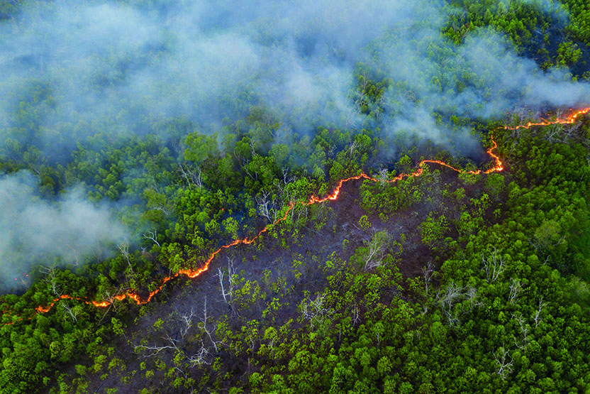
line of bush fire at peatland jungle in Sabah Borneo Malaysia
One of the main reasons for out-of-control forest fires is that extremely dry ground vegetation catches light rapidly, spreading the fire.
In New South Wales, Australia, ICT International has installed SFM1L sap flow meters and PSY1 stem psychrometers in bush areas. The first measures how much water a plant is using and the second monitors how lack of water is affecting it (that is, drying out, wilting). To transmit this data to irrigation departments or forest rangers, the devices use LoRaWAN (long-range wide area network), which is low power, and which has a range of up to 15km in urban environments.
The SFM1L and PSY1 measure plant water use (sap flow), soil moisture and vapour pressure deficit in real time, and identify conditions that make the area vulnerable to the rapid spread of fire, such as low soil moisture and high plant water stress. Additionally, these parameters can help to maintain the health of the trees so that they are part of an effective ecosystem.
The devices are based on Semtech’s LoRa technology. LoRaWAN uses the unlicensed industrial, scientific and medical (ISM) frequency band for bi-directional communication. It can typically transmit data at distances over 5-7km (three to 4.3 miles) in rural areas. The data rate is less than that of 5G and suitable for intermittent, small packets of data that is not mission-critical, such as temperature and moisture levels. The low power communications protocol means that batteries in networked nodes can last for up to 10 years, which is practical for installations that are difficult to reach for maintenance or replacement.
“The urban forest provides valuable eco services such as carbon sequestration through photosynthesis and cooling through shade and evapotranspiration. However, to perform these valuable functions the tree must be healthy,” says Dr Peter Cull, managing director at ICT International.
IoT – the internet of trees
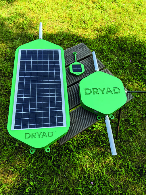
LoRa is also used in the Silvanet system to prevent the spread of forest fires. It was created by Dryad, a sensor node and networking start-up based in Berlin, Germany, in co-operation with Avnet Silica.
The central hardware element of Silvanet is the solar-powered Wildfire Sensor nodes. These measure environmental conditions, including concentrations of gases. Each sensor uses a low-power microcontroller that integrates LoRaWAN support and machine-learning processing. The sensors connect to solar-powered Silvanet Mesh Gateways using proprietary RF networking to form a mesh of star networks, extending deep into the forest.
The company calls this an ‘internet of trees’, which is linked to the internet via the Silvanet Border Gateway. Acting as a LoRa gateway, it can be placed at the edge of the forest and implements 4G, or 2G/GPRS connectivity if necessary.
The Silvanet cloud platform groups sensor devices and gateways either by geographical area or by characteristics for wildfire detection and monitoring.
Although LoRaWAN is used in urban environments, in forests, there are significant challenges for implementation, said Avnet Silica, including the fact that trees absorb radio waves.
The environment is also susceptible to fire risk, which is why it is being installed in the first place, but rechargeable batteries are potentially toxic and flammable, so Silvanet uses supercapacitors to power the sensors. The developers also had to bear in mind that the hardware has to be rugged enough to withstand long operating lifetimes deep in the forest. In addition, said the company, the firmware has to be suitable for energy-constrained data analytics, over-the-air update support, IoT security and LoRaWAN standards compliance. In addition, this all has to be achieved with equipment working at low power with solar panels that are often in shade.
Avnet Silica advised Dryad on the selection of low power components. The sensor node microcontroller that integrates LoRa radio, for example, has to have enough processing capability to effectively analyse sensor data to detect wildfires early.
Dryad has said that once a Silvanet infrastructure is in place, it could be used to monitor other aspects of forestry such as soil moisture, tree growth, sap flow and even illegal logging, as well as enabling air- and water-quality monitoring over large areas.
Listen to the trees
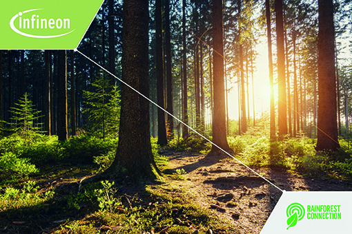
A mixture of acoustic-listening devices and gas-sensing technology, AI and machine learning is being proposed by Infineon and Rainforest Connection (RFCx) a non-profit organisation that monitors wildlife in the rainforest.
 RFCx uses acoustic technology, big data and AI/machine learning to protect rainforest habitat from forest fires and other dangers such as illegal logging. Collaborating with Infineon, RFCx wants to use Infineon’s gas-sensing technology to track rainforest ecosystems in various locations.
RFCx’s scalable, real-time monitoring system of acoustic sensors monitors the ecosystem soundscape at selected locations. Integrating Infineon’s gas sensors will allow users to detect fires, and other potential threats, in real-time. The acoustic system will be able to monitor activity in the remote rainforest areas and stream data to local agencies to prevent forest fires as well as to help prevent illegal deforestation and animal poaching.
Preserving the rainforest, says RFCx, is not only vital to halt climate change, but also for preserving it for many of the world’s poorest communities who rely on rainforests for food, shelter and livelihoods.
Bringing in AI
Back in New South Wales, Pano AI is conducting a pilot programme for an AI-powered detection and location of bushfires for Southern Cross Forests, an estate of softwood forests in the south of the state.
The San Francisco-based company was started in 2019 by Sonia Kastner, whose career included solar energy and battery storage as well as working at smart home hardware company Nest.
When “the sky turned red over San Francisco, when the Portland area got hit with devastating wildfires, when Colorado saw an unprecedented wildfire year, we saw that we couldn’t wait”, she told Bay Area Inno. Venture funding was raised “after that day the sky turned red” and accelerated R&D to develop the Pano Rapid Detect, a camera with integrated AI that rotates through 360° every minute to record a panoramic view of its surroundings.
The New South Wales pilot uses the Rapid Detect to gain greater situational awareness to help responders to forest and bushfires. The high-definition cameras provide 360° views. The data is merged with emergency calls and other available data feeds and AI produces a real-time picture of threats and provides emergency services with “rapid, actionable intelligence”. The company claims that its low rate of false-positive alerts enables fire and rescue services to allocate resources where they are needed most.
“Our industry is still recovering from the devastating bushfires of two years ago. We have to find more tools to help us detect fires and fight them as soon as they form,” says Jake Lazarus, general manager of Southern Cross Forests, New South Wales. “Pano’s all-in-one detection and notification system will help us detect small fires before they become larger threats to regional plantations and communities.”
“We built Pano Rapid Detect for partners like Southern Cross Forests that want to leverage AI and other cutting-edge technologies to stop bushfires from becoming catastrophic events that devastate communities, businesses, forests, and wildlife,” says chief commercial officer Arvind Satyam.
The company partnered with local governments and utility companies to deploy the early fire detection and notification system across high-risk fire zones in four US states. It reported that Rapid Detect had identified, confirmed and notified customers of more than 100 fires in these states in the 2021 fire season. In Colorado, the Aspen Fire Protection District uses Rapid Detect cameras to monitor smoke reports over 90 miles2 (233km2).
A University of Washington study shows that machine learning can improve lightning forecasts. As one of the natural sources of wildfires, the ability to understand where lighting can strike on dry vegetation can help protect those areas.
Combing the data from ground sensors about the health of vegetation and how dry particular areas are can improve wildfire monitoring and mobilise firefighers sooner.
“The best subjects for machine learning are things that we don’t fully understand. And what is something in the atmospheric sciences field that remains poorly understood? Lightning,” Daehyun Kim, a professor of atmospheric sciences at the University of Washington involved in the study, comments. “To our knowledge, our work is the first to demonstrate that machine-learning algorithms can work for lightning.”
 The study combined weather forecasts with a machine-learning equation based on analyses of past lightning events. The study’s authors say the method could forecast lightning over the south-eastern US two days earlier than the existing technique.
The researchers trained the algorithm using lightning data from 2010 to 2016. Then the machine-learning model was tested using weather models from 2017 to 2019, and data from satellite systems.
AI can detect smaller areas where weather and ground conditions are optimal for a fire to start, for local authorities to begin fire prevention activities and alert emergency services to focus on those areas.
AI is also used in global satellites to monitor precipitation, soil moisture levels at a forest canopy and surface levels. All of this data, together with weather and wind direction information, can identify areas at risk of fire. As AI advances, it may be used to model the fire intensity, direction of spread, and predict the level of resources needed to contain the fire.
The toll of long, hot summers
Forest or bush fire season is a part of a natural cycle that occurs in hot, dry areas such as Africa, Australia and Greece and states such as California and Oregon on the west coast of North America.
For centuries fires have removed harmful insects and disease to safeguard the vegetation and restored nutrients to the soil by burning debris on the ground. Fire clears space, allowing more ground to be exposed to sunlight, which creates a source of food and habitat for animals.
Today, however, instead of occurring naturally only through lightning strikes in dry spells, land management means setting controlled fires to achieve the same results. Other fires are caused by visitors not extinguishing campfires thoroughly, for example.
 Another contributor is power lines, which if not maintained can either fall, or come into contact with vegetation through overhanging branches, or component failure, causing power arcs.
The intensity of wildfires varies according to the weather conditions.
In particularly dry summers, the vegetation will be drier and therefore more sensitive to even small ignition triggers and will burn quicker. Changes in wind direction mean that even managed fires can be unpredictable and reach dry, unprotected areas that were not thought to be in its path.
Recent fire seasons have been dramatic and catastrophic. The 2019-2020 Australian bush fires destroyed 18.6 million hectares (46 million acres) nationwide. Of the destroyed area, around two-thirds were forest and bushland. The fires spread and killed millions of wild animals and insects, destroyed more than 3,000 homes and claimed 33 lives.
It was not the most vicious bush fire in the country’s history, however. In 2002, 38 million hectares (94 million acres) were destroyed in the North Territory and in 1974-1975 117 million hectares (290 million acres) were destroyed across New South Wales, the Northern Territory, Queensland, South Australia and Western Australia.
In the 2020-2021 season, the western coast of the US saw wildfires in California, Oregon and Washington State. Many of these were caused by thunderstorms igniting extremely dry vegetation and then being spread by strong gusts of wind. Around 4.1 million hectares (10.2 million acres) were destroyed in that wildfire season.
In November 2021, the National Interagency Fire Center reported more than 48,000 wildfires across the US had burned more than 6.5 million acres (2.6 million hectares) of land.