Next Weather Alert: Line of powerful storms sweeping over Minnesota, expected to weaken overnight
get the free appMINNEAPOLIS -- A "bow echo" line of powerful thunderstorms swept over northern Minnesota on Friday night, bringing hurricane-force winds to the Northland. The system prompted several tornado warnings as it moved over the Dakota border and into north-central Minnesota.
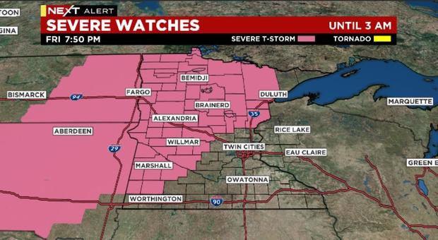
WCCO-TV meteorologist Lisa Meadows says the storm line is expected to drift toward central Minnesota in the overnight hours, weakening as it pushes deeper into the state. Still, a severe thunderstorm watch is in effect until 3 a.m. Saturday for a large swath of Minnesota, stretching from Marshall in the southwest to Ely in the Arrowhead.
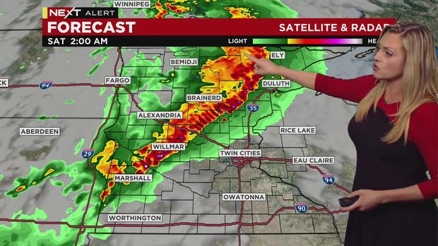
Additionally, a flood watch is in place for parts of central Minnesota that were slammed with several inches of rain Thursday night. Should communities in this area get another dousing of rainfall overnight, it could lead to flash flooding.
The Twin Cities area could see rain showers and storms after sunrise Saturday, but these storms are not expected to be severe. Currently, the metro area is not under the severe thunderstorm watch.
Skies across Minnesota are expected to clear out Saturday afternoon, leading to a cooler, less humid weekend. Temperatures Saturday are expected to climb near 80 degrees, while Sunday will bring below-average highs, in the mid-70s.
Tornado warning issued for Itasca, Cass counties
MINNEAPOLIS -- The National Weather Service has issued a tornado warning for parts of Itasca and Cass counties until 11:30 p.m.
Radar shows the storm line moving toward Bigfork, Squaw Lake and Balsam.
Tornado warning issued for north-central Minnesota
MINNEAPOLIS (WCCO) -- The National Weather Service has issued another tornado warning for part of north-central Minnesota.
The latest warning covers parts of Hubbard, Wadena, Becker, and Otter Tail counties, and it's slated to last until 11:15 p.m.
Forecasters say this tornado-warned cell is moving toward the towns of Menahga, Park Rapids, and Ninrod.
Tornado warning issued for cell tracking toward Park Rapids, Menahga
MINNEAPOLIS -- The National Weather Service issued a tornado warning for parts of Becker, Hubbard, Wadena, and Otter Tail counties until 10:45 p.m.
Radar images show the tornado-warned storm cell tracking toward the towns of Erie, Menahga, and Park Rapids.
The area is also under a severe thunderstorm warning, as the storm threatens 60+ mph winds and quarter-sized hail.
Another severe thunderstorm warning issued for north-central Minnesota
MINNEAPOLIS (WCCO) -- Another severe thunderstorm warning has been issued for north-central Minnesota.
The National Weather Service says this system is approaching the cities of Bemidji, Frohn, and Lake George. The warning is slated to last until 10:45 p.m.
The storm cell threatens 70+ mph winds, golf ball-sized hail and possible tornadoes.
Meanwhile, another severe system is moving over an area 50 miles to the north.
Severe thunderstorm warning issued for extreme north-central Minnesota
MINNEAPOLIS -- The same storm line that led to a tornado warning in extreme north-central Minnesota also prompted a severe thunderstorm warning in the area.
The National Weather Service issued a severe thunderstorm warning for parts of Roseau, Beltrami, Lake of the Woods, Marshall, and Clearwater counties until 10:30 p.m. The storm line is moving over Grygla and toward the towns of Waskish, Rainy River, and Kelliher.
While tornadoes are a threat, the system also could produce 70+ mph winds and golf ball-sized hail.
Tornado warning issued for far north-central Minnesota
MINNEAPOLIS -- The tornado warning in extreme northwestern Minnesota is moving into the north-central part of the state.
The National Weather Service has extended the warning until 10:15 p.m. The tornado-warned cell is moving toward Grygla, Four Town and Ponemah.
Another tornado warning issued near Mahnomen
MINNEAPOLIS -- A second tornado warning is in effect in northwestern Minnesota, this time near the town of Mahnomen.
The National Weather Service says the tornado-warned cell is moving toward Pembina township, Pine Bend and Roy Lake. The warning is slated to last until 9:45 p.m.
Meanwhile, another tornado warning is in effect about 60 miles to the north, tracking toward High Landing, Goodridge and Grygla.
Powerful storms moving into north-central Minnesota
MINNEAPOLIS -- A line of thunderstorms capable of producing hurricane force winds is moving into north-central Minnesota.
The National Weather Service has issued a severe thunderstorm warning for parts of Beltrami, Clearwater, Polk, Mahnomen, Hubbard, Pennington, Marshall, and Red Lake counties until 9:45 p.m.
Weather officials say the storm cell remains capable of producing 70+ mph wind gusts and golf ball-sized hail.
The storm line is moving toward Bemidji, Lower Red Lake, and Northern Township.
Another thunderstorm warning issued along North Dakota border
MINNEAPOLIS -- Another severe storm cell is moving across the North Dakota border into Minnesota.
The National Weather Service has issued a warning for parts of Cass, Clay, Norman, Becker, Wilkin, Mahnomen, and Ottertail counties.
This cell appears to be less severe than previous ones. Still, it could produce 60 mph wind gusts and quarter-sized hail.
Forecasters say the cell is tracking toward Fargo, Moorhead and Detroit Lakes.
Severe storms continuing to push into northern Minnesota
MINNEAPOLIS -- Powerful storms are continuing to push into northern Minnesota, threatening hail and hurricane-force winds.
The latest severe thunderstorm warning covers parts of Polk, Clearwater, Mahnomen, Norman, and Red Lake counties. It's set to last until 9:15 p.m.
National forecasters say the storm cell is capable of 70+ mph winds and golf ball-sized hail. The storms line is moving east toward the towns of Fertile, Fosston, and McIntosh.
More severe thunderstorm warnings for northwestern Minnesota
MINNEAPOLIS -- The National Weather Service has issued another batch of severe thunderstorm warnings for northwestern Minnesota. The powerful storms are blowing into the area, threatening wind gusts over 80 mph.
The latest warning affects parts of Pennington, Marshall, Red Lake, Polk, Kittson, and Roseau counties, and the alert is set to last until 9 p.m.
Along with damaging winds, the storms could also produce baseball-sized hail, forecasters say. The storm cell is currently moving toward the towns of Red Lake Falls, Thief River Falls, and Warren.
Tornado warning issued for Kittson, Marshall counties
MINNEAPOLIS -- A tornado warning is in effect for parts of Marshall, Kittson, and Roseau counties until 8:15 p.m.
Forecasters say the tornado-warned cell is moving toward the cities of Karlstad, Newfolden and Viking.
Severe thunderstorm watch extended to cover much of northern, central Minnesota
MINNEAPOLIS (WCCO) -- The National Weather Service has extended the severe thunderstorm watch to cover a large swath of northern, central and western Minnesota.
Powerful thunderstorms are currently rumbling over the northwestern corner of the state, and they will threaten north-central Minnesota as they move east in the overnight hours.
The updated watch is slated to last until 3 a.m. Saturday, although the storms are expected to weaken as they move deeper into Minnesota.
Forecasters say the storms could produce damaging wind gusts and hail the size of golf balls. Isolated tornadoes are also possible.
Winds over 80 mph possible in northwestern Minnesota
MINNEAPOLIS -- Severe storms blowing into northwestern Minnesota are threatening 80+ mph winds and baseball-sized hail. Tornadoes are also possible.
The National Weather Service has extended severe thunderstorm warnings to include parts of Pennington, Polk, Marshall, Red Lake, Kittson, and Roseau counties.
Radar shows the storms moving toward the cities of Warren, Thief River Falls, and Red Lake Falls.
Severe t-storm warnings extended to several counties in northwestern Minnesota
MINNEAPOLIS -- Several counties in northwestern Minnesota are now under severe thunderstorm warnings.
The National Weather Service has issued a warning covering parts of Pennington, Polk, Marshall, and Red Lake counties until 7:15 p.m.
According to forecasters, the storm line is moving toward the cities of East Grand Forks, Euclid, and Thief River Falls.
The storms threaten 70 mph winds and hail the size of golf balls.
Severe t-storm warning issued for Norman, Polk counties
MINNEAPOLIS -- A severe thunderstorm warning has been issued for parts of Norman and Polk counties in northwestern Minnesota until 7:15 p.m.
Forecasters say a severe storm cell is moving toward the cities of Crookston, Hillsboro and Mayville. Threats include damaging winds up to 60 mph and quarter-sized hail.
Severe t-storm warning issued for Marshall, Polk counties
MINNEAPOLIS -- The National Weather Service has issued a severe thunderstorm warning for Marshall and Polk counties until 6:30 p.m.
Forecasters say the severe storms are moving over the Dakota border, tracking toward East Grand Forks and Warren, threatening baseball-sized hail and 80 mph winds.
Residents in the storm's path are urged to seek shelter.
