Old Man Winter makes return to Northeast as April arrives


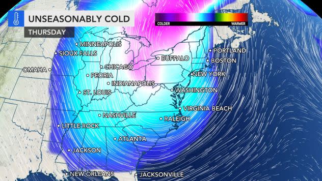


Following a delightful day Tuesday with sunshine and a balmy breeze, temperatures will be slashed by 30-50 degrees Fahrenheit in much of the Northeast as a blast of cold air marks the beginning of April. And AccuWeather forecasters say the winterlike weather is "no joke." Snow is forecast to fall and accumulate in part of the region as cold winds add to the winterlike feel late this week.
Early April will feel more like the middle of February, especially from Thursday to Friday.
An advancing cold front is setting into motion a change to colder weather from west to east into the latter part of this week.
"It's a roller coaster ride here in the Northeast. You could actually call it weather whiplash," AccuWeather On-Air Meteorologist Brittany Boyer said. "It's going to go from feeling like spring to feeling like winter."
 |
Rain associated with the cold front initiated the temperature change on Wednesday from the Appalachians on westward. For many areas from West Virginia and the western parts of Maryland, Pennsylvania and New York state on west, temperatures were no higher than the 50s and began to fall during the daylight hours in some cases.
Farther to the east Wednesday, another mild day was had by millions with highs mainly in the 60s along much of the Interstate 95 corridor. A few spots even approached 70. However, colder air is coming for the East Coast too.
The temperature drop across the Appalachians and areas farther west will be the most dramatic through Thursday morning as a storm moves northeastward along the shifting cold front.
"The storm will help draw in even colder air and allow rain to become mixed with and change to snow in many locations from the Appalachians on west to parts of the Ohio Valley and Great Lakes," AccuWeather Senior Meteorologist Brett Anderson said.
 |
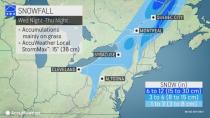
The AccuWeather radar early Thursday morning, April 1, 2021, shows snow (blue) falling across portions of the Great Lakes and interior Northeast. (AccuWeather) |
Buffalo, New York; Pittsburgh; and Charleston, West Virginia, are among some of the cities that can expect a small accumulation of snow through Thursday. However, the ridges in the central and northern Appalachians as well as some cities even at lower elevations can pick up several inches of snow, mainly on grassy surfaces.
An AccuWeather Local StormMax™ of 15 inches (38 centimeters) is forecast to fall on part of southeastern Quebec with close to a foot of snow expected over the ridges and peaks of northwestern New England.
"Generally, we expect much less snow to accumulate on roads versus say grassy areas and on the roofs of cars," AccuWeather Senior Meteorologist Rob Miller said.
But, AccuWeather meteorologists warn that there could be some dicey conditions on some stretches. In areas where the April sun warms road surfaces, it's likely to just be wet. Bridges and elevated road surfaces, however, can cool down more rapidly, leading to slushy spots.
 |
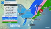
No snow is expected to fall along the I-95 corridor of the Northeast. Instead, soaking rain is forecast to pour down into the first part of Thursday. However, it is possible for a few snowflakes to fall in the northern and western suburbs of Philadelphia and New York City at the tail end of the storm Thursday.
And in areas with accumulating snowfall, dangers could persist even after the snow ends. In the wake of the steady snow, very cold air that will move in high in the atmosphere is likely to trigger locally heavy snow squalls from the eastern Great Lakes to the central Appalachians.
CLICK HERE FOR THE FREE ACCUWEATHER APP
The squalls could usher in quick bursts of snow, or in some cases, soft hail. The wintry precipitation could be intense enough to quickly coat roads and also lead to a sudden drop in visibility. That could be more problematic for motorists who are traveling at highway speeds, according to AccuWeather Meteorologist Jake Sojda.
Snow squalls have contributed to multiple-vehicle pileups in the past, including on stretches of I-76, I-80 and I-81.
 |
By Friday morning, the cold air will have a firm grip throughout the region. Temperatures are expected to range from the middle teens in northern New York state to the middle 30s in southeastern Virginia and the middle 40s in coastal New England. Temperatures may climb no higher than the 20s and lower 30s over the ridges in New York state, Pennsylvania and West Virginia during Friday afternoon.
Actual highs Friday are forecast to be in the lower 40s in New York City and Pittsburgh, the middle 40s in Philadelphia and Boston, and the upper 40s in Washington, D.C.
And it won't just be the temperatures that will make it feel wintry, according to Boyer. Gusty winds are expected to accompany the blast of colder air. Even though the wind may not be strong enough to lead to property damage and widespread power outages, where heavy, wet snow clings to trees over the higher elevations, sagging branches under the weight can trigger sporadic power line damage and outages.
The main role of the wind will be to make it feel even colder than the actual temperature by as much as 20 degrees in some cases. AccuWeather RealFeel® Temperatures are forecast to be in the single digits, teens and 20s Friday morning. The sun may struggle to help it feel slightly warmer during the afternoon.
Even though a few places may come close to record temperatures for April 2 and 3, a wind or breeze may prevent widespread records from being set. The wind tends to keep the atmosphere mixed enough to keep the coldest air from settling near the ground. Clear and calm conditions along with deep snow cover is the best way to send temperatures plummeting at night. In this case, most places will only have one or two of the three components in place.
Still, daily record lows may be eclipsed in some locations Friday morning. The record of 19 set in 2019 in Bradford, Pennsylvania, could be challenged as well as the 19-degree record that has stood since 1954 in Beckley, West Virginia.
AccuWeather meteorologists say the weather pattern won't ease up too quickly over the Easter weekend and beyond. Instead, an atmospheric traffic jam is forecast to develop from the central Atlantic to the central United States. The setup will tend to keep the Eastern states chilly at night but a bit milder during the day Saturday and Easter Sunday. For outdoor sunrise services Sunday, temperatures are forecast to range from the middle 20s in northern Maine to the middle 40s in eastern Virginia.
Most places in the East can expect light winds each day during Easter weekend, especially when compared to Thursday and Friday. Where the sun comes out, it may feel comfortable for a few hours during the afternoon hours. A gradual daily warming trend in temperature is predicted to take place this weekend into early next week.
It is possible that a patch of clouds and spotty showers may ensue over part of the Northeast for a time this weekend.
Highs on Easter Sunday afternoon are forecast to range from the middle 40s in northern Maine to the lower 70s in southeastern Virginia.
It won't be a far cry from last Easter in the East when temperatures reached 60 degrees in Boston and 69 degrees in Philadelphia, which is about 5-10 degrees above normal. Meanwhile, an unusually late-season snowfall had some residents in the Twin Cities wishing others a "Merry Easter" on April 12 last year.
Keep checking back on AccuWeather.com and stay tuned to the AccuWeather Network on DirecTV, Frontier, Spectrum, FuboTV, Philo, and Verizon Fios.
