
At a Glance
- Severe thunderstorms erupted from Texas to the lower Mississippi Valley on October 20-21.
- Thirty tornadoes were confirmed by the National Weather Service.
- The strongest tornado tore through the north side of Dallas.
Severe thunderstorms spawned tornadoes from Texas to the lower Mississippi Valley in less than 24 hours from October 20-21, including a strong nighttime tornado over the highly-populated Dallas metro area.
(NEWS: Tornado Destroys Homes, Businesses in Dallas)
The National Weather Service confirmed 30 tornadoes in six states from North Texas to western Tennessee and southeast Louisiana.
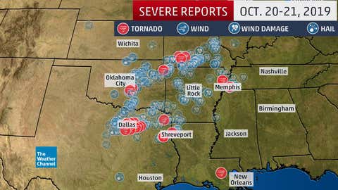
Twelve of those tornadoes touched down in North Texas.
The strongest, an EF3, tore an almost 16-mile-long path in just over 30 minutes through the north side of Dallas County, Texas, on the night of October 20.
According to meteorologist William Churchill of the National Weather Service, radar 150 miles west of Dallas detected lofted debris from the Dallas County tornado up to 20,000 feet above the ground, usually an indication of a stronger tornado. According to the NWS damage survey, the tornado was estimated to be up to three-quarters of a mile wide.
This was the strongest tornado in Dallas County since a deadly EF4 tornado on Dec. 26, 2015 tore through Sunnyvale, Garland and Rowlett.
(MORE: Aerial Photo Shows Power Outage Path in Wake of Dallas Tornado)
Four other tornadoes struck the suburbs just northeast of Dallas: an EF2 tornado in Garland, an EF1 tornado in Rowlett, an EF1 tornado in Rockwall and an EF0 in Collin County, according to the NWS-Fort Worth.
Five other weak tornadoes were confirmed south and southeast of Dallas.
Several tornado warnings were issued as the squall line roared through the Memphis metro area around 6:30 a.m. CDT Monday. One strong rotation on radar passed near Memphis International Airport, prompting airport officials to evacuate planes and direct those in the airport to tornado shelter. Some windows were blown out in the airport's terminal. A peak wind gust of 53 mph was clocked at the airport.
Power was knocked out to at least 35,000 customers in western Tennessee due to the storm. The area of strong rotation later passed over the suburb of Germantown, downing a tree onto a home and downing other trees and power lines.
After surveying the area Monday, the NWS found evidence of EF1 tornado damage around the Cottonwood Apartments in Memphis.
Just before 6 a.m. CDT Monday, a tornado tore through Tyronza, Arkansas, about 30 miles northwest of downtown Memphis, destroying or damaging several homes and businesses, downing numerous trees and blowing over a semi, according to KAIT-TV. The NWS office in Memphis assigned a preliminary EF1 rating to this tornado.
In northwest Arkansas, an EF2 tornado was on the ground for just over 31 miles from Siloam Springs to east of Rogers, Arkansas. Striking just after midnight on October 21, the tornado's damage path was estimated to be up to 1.5 miles wide.
Seven tornadoes rated EF0 or EF1 were confirmed in southwest Missouri, five EF1 tornadoes were confirmed in eastern Oklahoma and a brief EF0 tornado damaged warehouses in Geismar, Louisiana.
According to NOAA's Storm Prediction Center (SPC), there were just over 240 preliminary reports of severe weather on October 20-21, primarily in North Texas, Oklahoma, Arkansas and southern Missouri. It was the most active 24-hour period of severe weather in the U.S. since Aug. 20, according to SPC data.
The Weather Company’s primary journalistic mission is to report on breaking weather news, the environment and the importance of science to our lives. This story does not necessarily represent the position of our parent company, IBM.


