Potential for tornados, flooding Friday in Tri-State area: National Weather Service
It's expected to be a stormy start for the Memorial Day weekend with tornado and flood watches in effect for Washington County and parts of the region Friday, according to the National Weather Service.
There could be spots in the Tri-State area that see 3 or more inches of rain through thunderstorms and 1 to 2 inches in short periods of time, leading to the possibility of flash flooding, according to the service's weather advisories.
A tornado watch is already in effect for Berkeley, Jefferson and Morgan counties in West Virginia until 2 p.m. Friday. Another tornado watch was issued for Washington County and several counties to the east — and west of the Chesapeake Bay — until 2 p.m., according to the weather service's website.
Stay weather aware today! Severe thunderstorms possible with the potential for damaging wind gusts, a couple tornadoes, large hail and flash flooding. Multiple rounds of storms are expected. The greatest risk will be this afternoon/evening. Latest: https://t.co/5RyZgoXicj pic.twitter.com/9IETnnSN8N
— NWS Baltimore-Washington (@NWS_BaltWash) May 27, 2022
In other parts of Pa.: Flood watch issued as heavy storms to roll through central Pa.; tornado can't be ruled out
Memorial Day looks better: Going to a crab feed this summer? Half the fun is picking out the meat
Even after the tornado watch is over, there's potential for thunderstorms Friday evening after 6 p.m., said meteorologist Andrew Snyder with the Baltimore/Washington forecast office.
"It's not out of the question that a few of those could be severe," Snyder said.
They include the risk of damaging winds and isolated gusts up to 60 mph or more, he said.
A flood watch has been issued for today for the region.
That watch, as of Friday morning, runs from 11 a.m. to 11 p.m. for the local Maryland, West Virginia and Virginia areas. The watch is in effect from 2 p.m. to 10 p.m. for the local Pennsylvania area, including Franklin County.
People in those areas are urged to monitor weather forecasts throughout the day and take precautions in case of flooding around waterways, low-lying areas and flood-prone spots, according to the flood watch.
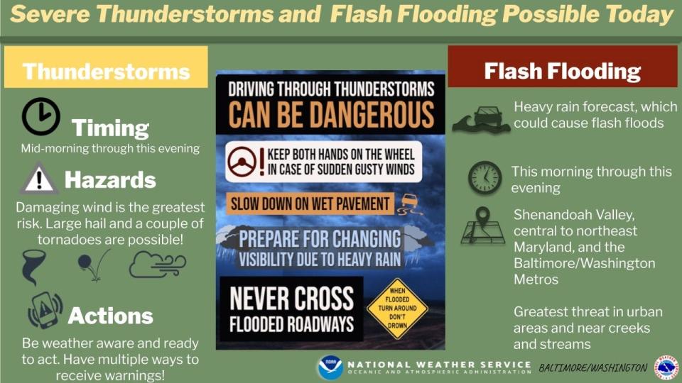
Damaging wind gusts and the possibility of hail could come with a potential tornado.
While a tornado watch had not been issued for the local Pennsylvania area, a hazardous weather outlook still calls for the possibility of an "isolated weak, short-lived tornado" and the potential for wind gusts up to 60 mph or more with thunderstorms.
The high today is expected to be around 75 degrees.
The entire holiday weekend is not expected to be a washout.
There is a chance of isolated to scattered showers and thunderstorms Saturday afternoon, but it is not expected to rain all day, Snyder said. Sunday and Monday are anticipated to be dry.
For the Tri-State region, the high is expected to be in the low to mid 80s on Sunday and in the high 80s to low 90s on Memorial Day, according to the National Weather Service's website.
It's expected to be hotter toward the middle of next week, with a high of 92 degrees forecast for Greencastle, Pa., on Tuesday.
Temperatures will probably be in the upper threshold of what's typical for this time of year, Snyder said. With June starting Wednesday, we're getting closer to more hotter days.
This article originally appeared on The Herald-Mail: Tornado, flood watches in effect in Washington, Franklin counties

