Tropical Storm Warning In 9 NJ Counties For Tropical Storm Fay
NEW JERSEY — A tropical storm warning was issued in nine New Jersey counties for a storm that's expected to impact the region on Friday. Tropical Storm Fay is supposed to pack 60-mph winds and may spawn tornadoes.
Patch has provided an update to the storm, with complete predictions. Read more: Tropical Storm Fay In NJ: Timeline, Hour-By-Hour Forecast
Here are the alerted areas as New Jersey deals with its first tropical storm warning in many months:

The National Hurricane Center said the low-pressure system is currently forecast to track across the region and bring heavy rain and thunderstorms, according the National Weather Service out of Mount Holly.
The weather could impact outdoor graduations that have been allowed to take place amid the coronavirus outbreak. Read more: NJ Coronavirus, Reopen Updates: Here's What You Need To Know
The bad weather is expected to start after midnight, and heavy rain and thunderstorms — some of them possibly severe — are forecast to last all day. The NWS said the chance of rain is 100 percent. The worst of it is expected to happen in the late afternoon.
Here is the storm's track:

Here is what to expect:
A tropical storm warning means tropical storm-force winds are expected somewhere within this area within the next 36 hours.
Peak wind forecast: 30-40 mph with gusts to 45 mph. Potential for wind 39 to 60 mph
Last minute efforts to protect property should now be complete. The area remains subject to limited wind.
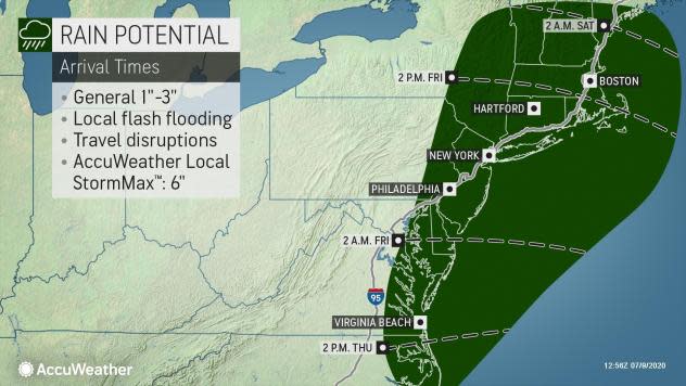
Peak rainfall amounts: 1-3 inches, with locally higher
Localized rainfall flooding may prompt a few evacuations.
Stay within your shelter keeping informed of the latest tornado situation.
A few places may experience tornado damage, along with power and communications disruptions.
Locations could realize roofs peeled off buildings, chimneys toppled, mobile homes pushed off foundations or overturned, large tree tops and branches snapped off, shallow-rooted trees knocked over, moving vehicles blown off roads, and small boats pulled from moorings.
AccuWeather published a timeline:
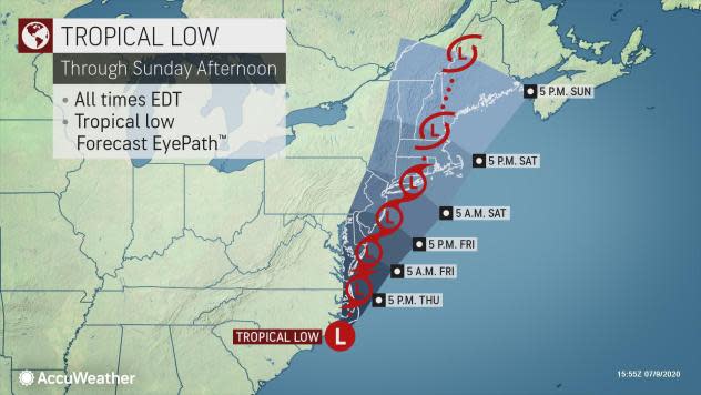
The National Hurricane Center, in its most recent briefing on the weather event, said thunderstorm activity increased overnight off the coast of North Carolina.
"The thunderstorm activity is currently located well east and northeast of the low's center; but only a small increase in organization or a reformation of the center closer to the thunderstorm activity could result in the formation of a tropical or subtropical cyclone later today or tonight," the National Hurricane Center said.
The low is expected to move northeastward or north-northeastward near or just offshore of the Outer Banks later Thursday and then along the mid-Atlantic coast Thursday night through Friday night.
"Regardless of development, the system is expected to produce locally heavy rainfall that could cause some flash flooding along the mid-Atlantic region. Gusty winds are also possible."
An Air Force Reserve Hurricane Hunter aircraft is scheduled to investigate this system later, the National Hurricane Center said.
The Weather Channel said the mid-Atlantic coast can expect heavy bands of rain and poor beach conditions, including dangerous rip currents.
Here is the forecast:
Friday: Showers and possibly a thunderstorm. Some of the storms could produce heavy rainfall. High near 82. Northeast wind 10 to 15 mph. Chance of precipitation is 90 percent. New rainfall amounts between 1 and 2 inches are possible.
Friday night: Showers likely and possibly a thunderstorm. Some of the storms could produce heavy rainfall. Mostly cloudy, with a low around 70. Calm wind becoming north around 5 mph. Chance of precipitation is 70 percent. New precipitation amounts between a half and three-quarters of an inch are possible.
Saturday: A chance of showers, with thunderstorms also possible after 2 p.m. Partly sunny, with a high near 90. Southwest wind around 5 mph. Chance of precipitation is 50 percent. New rainfall amounts between a tenth and quarter of an inch are possible, except higher amounts in thunderstorms.
Saturday night: A chance of showers and thunderstorms. Partly cloudy, with a low around 72. Chance of precipitation is 30 percent. New precipitation amounts of less than a tenth of an inch are possible, except higher amounts in thunderstorms.
Sunday: A chance of showers after 8am. Mostly sunny, with a high near 90. Chance of precipitation is 40 percent.
Sunday night: Partly cloudy, with a low around 70.
Monday: A chance of showers and thunderstorms after 2 p.m. Partly sunny, with a high near 91. Chance of precipitation is 50 percent.
Monday night: A chance of showers and thunderstorms. Partly cloudy, with a low around 70. Chance of precipitation is 40 percent.
This article originally appeared on the Toms River Patch

