Olympic national park
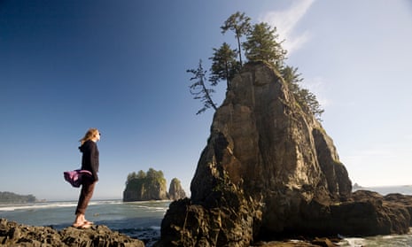
If you only have time to visit one park in Washington, make it Olympic. Located out on the Olympic Peninsula in the north-west corner of the state, this massive wilderness offers everything from tide pools to mossy rain forests to glacier-capped mountains.
Jutting out into the Pacific and separated from the mainland by the Puget Sound and the Straight of Juan de Fuca, the Olympic Peninsula receives more rainfall than any other place in the US except Hawaii. High in the 2,000-metre-plus Olympic mountains, much of that precipitation falls in the form of snow, which feeds more than 250 glaciers, making this the most glaciated US terrain outside Alaska. The extensive ice fields flow into a number of major rivers, which wind their way down through temperate rain forests to the Pacific.
Visitors can see the highlights by following the Bogachiel river from its Pacific outlet at La Push inland to the Hoh rainforest. The next day, circle around to the northeast and head up in elevation to Hurricane Ridge, which has a breathtaking view over the Olympic mountain range. Those with extra time will want to soak in the Sol Duc hot springs and take a scenic stroll to Marymere Falls. Lodging is available at Lake Crescent and Sol Duc and numerous campgrounds are scattered throughout the park.
Top tip: The Hall of Mosses trail in Hoh is a short, one-mile loop through old growth rainforest. The only greenery more impressive than the massive trees are the prodigious mosses and lichens hanging from every branch. Keep an eye out for trophy elk, which grow to massive sizes here.
North Cascades national park
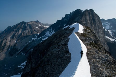
Home to grizzly bears, grey wolves, lynx and wolverines, the North Cascades park offers a true wilderness experience, despite being only a three hour drive from Seattle.
Except for scenic highway 20, which runs east to west through the park, North Cascades is crossed by few roads – but is bisected by the US-Canada border. The lack of easy access attracts backpackers and mountaineers to the North and South Picket ranges, Mount Triumph and Mount Redoubt, peaks world-renowned for their challenging terrain. You don’t have to be a mountaineer to enjoy the North Cascades, however; many one-day trails leave from highway 20. The famous Pacific Crest trail crosses the east section of the park on its way from Mexico to Canada. The Ross Lake national recreation area, located in the north unit, also offers boating and fishing, while rafters and kayakers can find white water on the Skagit and Stehekin rivers.
Top Tip: As many as 10,000 years before the fur trade brought the first white men to the North Cascades, Native Americans were using the Cascade Pass as a route through the mountains. Today it’s accessed from the west by a four-mile trail at the end of the Cascade River Road.
Mount Rainier national park
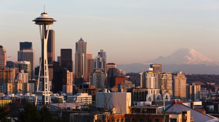
On clear days, the roof of Washington – the 4,392-metre Mount Rainier – is visible to the southeast from Seattle, 54 miles away. But the Evergreen State is not known for its clear days; rain and fog are persistent here year round. Still, if you’re lucky enough to catch even a glimpse of the mountain, you’ll likely want to get a closer look at its snowy summit.
The best views of Rainier are from the Sunrise Lodge in the north-east section of the park. Here you can drive up to an elevation of just under 2,000m. To get even closer you’ll need an ice axe, crampons and mountaineering experience. Each year, around 11,000 people attempt to climb Rainier, with a success rate of about 50%. Most expeditions last two days and require an elevation gain over 2,700m. Even experienced climbers are encouraged to climb with a guide; since the late 1800s around 100 people have died on Rainier from rockfall, avalanches, falls and hypothermia. Bring binoculars and watch the ants ascend the mountain from the comfort and safety of the lodge.
Top tip: The 93-mile Wonderland Trail circumnavigates Mount Rainier, giving backpackers the best possible look at the mountain from all sides. Hiking the entire trail takes about two weeks, but there are many options for shorter trips and day hikes.
Park website
Mount Rainer climbing guide, Alpine Ascents International
Discovery Park
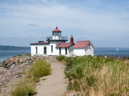
This urban park, on the Puget Sound waterfront, is Seattle’s largest green space. Despite being at the edge of a major metropolitan city, on the grounds of a former Army post, Discovery Park is famous for its wild residents. The Seattle Audubon Society has compiled a checklist of 270 bird species and large mammals: coyotes, black bears and cougars have been spotted within the 534-acre park. Seals and sea lions are also frequent visitors and the park protects more than two miles of tide pool-rich shoreline.
Discovery Park is also home to the Daybreak Star Cultural Center, a hub for Native American cultural gatherings in the Pacific Northwest. The 20-acre site offers workshops, powwows, social services and an art gallery and repository for traditional art. Several dozen tribes are native to Washington and the Seattle area and this centre is an important resource for education and cultural outreach.
Top tip: One of the most popular treks is the Discovery Park Loop Trail, which was designated a National Recreation Trail in 1975. This 2.8-mile path connects to an additional nine miles of hiking trails.
Cape Disappointment state park
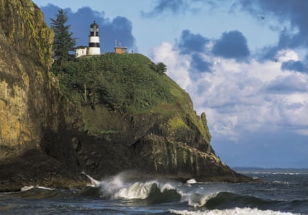
Don’t let the name mislead you, there’s nothing disappointing about this state park on the very south-west tip of the Washington coast. The name was coined in 1788 when an English ship searching for the outlet of the (then unnamed) Columbia river, which passes just south of the Cape, missed the passage over the river’s sand bar and was forced to turn back, leaving the Columbia unexplored until 1792.
The park also marks the end of the journey made by Lewis and Clark in 1805, the first American expedition to cross what is now the western US, from St Louis, Missouri, to the Pacific. The park’s Lewis and the Clark Interpretive Center tells the story of their journey.
Lighthouse enthusiasts will also delight in the North Head and Cape Disappointment lighthouses. The latter, built in 1856, is the oldest functioning lighthouse on the west coast.
If history isn’t your thing, the park also offers plenty of coastal scenery, including eight miles of hiking trails to secluded coves. A large campground caters to both RVs and tents, and 14 beachside yurts and three cabins are also available for rental.
Top tip: Between December and March, Pacific grey whales migrate past the Cape from their Arctic feeding grounds to their breeding grounds off Mexico. The higher ground around the Lewis and Clark Interpretive Center and North Head lighthouse offer the best viewing.
Flaming Geyser state park
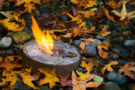
This name is also a bit misleading. There was once a dramatically flaming geyser here – an eruption of gas and seawater about eight metres tall that sprung from a test well dug by miners in the early 1900s. The methane gas that sparked that flaming eruption is still present, but now it feeds a flame only a few inches high that is safely contained in a rock rimmed basin. Nearby, the gas also bubbles up through a mud hole to create Bubbling Geyser. Both geysers can be seen on a short walk from the picnic area along Cristy Creek.
The geysers are definitely worth a look, but the real draw of this park is the Green river, three miles of which flow through the park. Depending on the water level, which varies with rainfall and snowmelt, the Green is popular with rafters and kayakers when high and with canoeists and tubers when low.
Top tip: From October to December, fishermen descend on the river in hope of catching a giant wild Chinook, the largest type of Pacific salmon, which are then migrating upstream to their spawning grounds. This is a popular time at the park for both fishermen and salmon watchers, who can learn more about the fish’s curious life cycle on the park’s Salmon Interpretive Trail.
Mount Saint Helens national monument
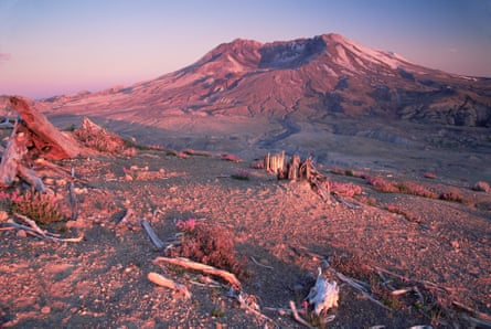
On May 18, 1980, Mount St Helens exploded, killing 57 people and incinerating over 200 homes and hundreds of miles of roads in the deadliest and most destructive volcanic eruption in US history. Over 30 years later, the scars from the eruption are still visible on the mountain – which lost over 450 metres of elevation in the blast – and across the surrounding countryside.
Visiting Mount St Helens is a lesson in the rejuvenating power of nature. The national monument was created in 1982 so that the area surrounding the volcano could be allowed to recover naturally from the blast. Ongoing scientific monitoring of the area’s forests, rivers and streams are revealing a speedy return to health and increased biodiversity of both plants and animals.
The best views of the volcano are had from the Windy Ridge viewpoint and the Johnston Ridge observatory. Ambitious hikers can climb to the top of the volcano and look down into the summit caldera, which still shows signs of volcanic activity. The 28-mile Loowit trail encircles Mount St Helens, giving backpackers a 360-degree view of the mountain and the impressive blast recovery zone.
Top tip: After you’ve seen the volcano, go underground into Ape Cave, a network of subterranean lava tubes. A 2.6-mile trail links two of the biggest, most accessible lava tubes, the lower and upper tubes. Be sure to take a powerful flashlight, extra batteries and layers: the temperature in the caves stays at 5C to 6C year round.
Sacajawea state park
When Lewis and Clark and their company of men made their way by foot and canoe from Missouri to the Pacific, they were accompanied by a Lemhi Shoshone woman named Sacajawea. Sacajawea’s native survival skills were a huge asset to the expedition and she’s often given a share of the credit for its success.
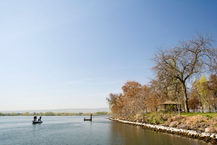
Sacajawea state park celebrates her role in the legendary journey. It is at the confluence of the Snake and Columbia rivers in Pasco, on the site of a camp used by the expedition for two days in October 1805. Today, there is one campground within the park, but it’s only accessible by boat.
The Interpretive Center tells the Lewis and Clark story through Sacajawea’s eyes. There are also thousands of native artefacts on display, including bone and stone tools dating back 12,000 years.
Top tip: The park lies along the Northwest Discovery Water Trail, a 367-mile long recreational boating route stretching from the Clearwater river in Idaho to the Bonneville dam in the Columbia river gorge between Oregon and Washington. Most boaters canoe or kayak the route, though motorboats and sailboats can be used in some sections.
Park website, Sacajawea Interpretive Center
San Juan Islands national monument
Created in 2013 to protect this unique pocket of marine biodiversity in the northern Puget Sound, this is one of the newest parks in Washington. Over 400 islands make up the San Juans; some are blanketed with lush rainforest while others are barren spires of rock. The varied habitats support a diversity of wildlife, including back-tailed deer, mink, river otters and many species of birds.
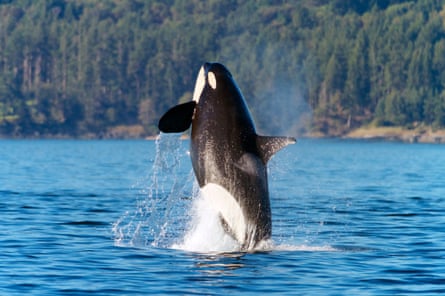
The stars of the San Juans, however, are the orcas: three pods of killer whales frequent the waters surrounding the islands from mid-April to October, when they hunt the healthy population of seals. One pod often stays in the area year round and transient pods and lone whales can also be seen year round. Grey, minke and humpback whales as well as dolphins also visit the islands. Several companies offer whale-watching boat tours, or you can try your luck at spotting spouts from a clifftop vantage point at Lime Kiln Point state park. Fishing, crabbing, and kayaking between the islands is also popular.
Top tip: To get a bird’s-eye view of the San Juan islands, hike up Mount Constitution in Moran state park on Orcas Island. This 6½-mile round trip hike is well worth the effort: on clear days you’ll be able to see the whole San Juan archipelago, as well as east to the Mount Baker volcano in the Cascade range.
Park website, whale and wildlife watching, hiking trails
Sun Lakes-Dry Falls state park
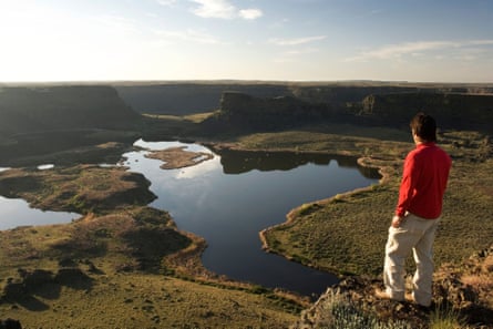
Around 15,000 years ago, towards the end of the last Ice Age, a series of massive floods swept across Washington, set off by the breaking of ice dams on proglacial Lake Missoula in what is now western Montana. These floods, among the largest to ever occur on Earth, left scars on the landscape that can still be seen today. One of the most dramatic scars is preserved at Sun Lakes-Dry Falls State Park: a 120-metre-high, 3½-mile-long cliff that was once a waterfall four times the size of Niagara, thought to be one of the largest in geologic history and the site is designated a National Natural Landmark.
The former waterfall is now dry as a bone but water is still present in the Sun Lakes, a haven for fishing, swimming and boating in this otherwise arid desert landscape. Camping is very popular in the park, which offers over 150 campsites for RV’s and tents. There are also boat rentals in the summer.
The best views of Dry Falls are had from the Vista House Overlook and the Dry Falls visitor centre features displays about the geology and natural history of the area.
Top tip: During the great floods, Umatilla Rock would have been an island in the midst of raging waters. The five-mile round trip trek to the rock offers outstanding views of Dry Falls and the Grand Coulee below the former falls.
Mary Caperton Morton is a freelance writer and photographer who makes her home on the back roads of North America, living and working out of a tiny solar-powered Teardrop trailer. Follow her travels at theblondecoyote.com


Comments (…)
Sign in or create your Guardian account to join the discussion