


Thunderstorms dropped torrential rain across the Lowcountry June 12, knocking out power, flooding streets and prompting a flash flood warning from the National Weather Service.

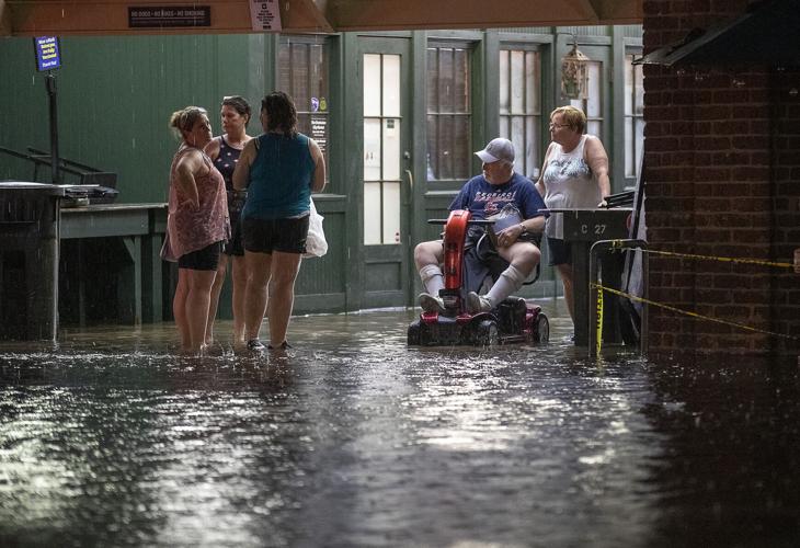
The City Market floods from several inches of rain that fell closing off streets surrounding the Market Street area Saturday, June 12, 2021 in Charleston. Grace Beahm Alford/Staff
The storms dropped extremely heavy rainfall from Red Top through West Ashley into portions of James Island and downtown Charleston, according to the NWS.
NWS reported at 8 p.m. Avondale in West Ashley recorded approximately 3.5 inches of rain from storms that began around 6 p.m. Waterfront Park in downtown Charleston recorded 4.4 inches of rain in that time, and Patriots Point in Mount Pleasant recorded 2.3 inches.
The flash flood warning is scheduled to run until 10:15 p.m.
A photo posted on social media showed shoppers at the Charleston City Market sitting on top of display booths to escape floodwaters that flowed through the market's main thoroughfare.

The City Market floods from several inches of rain that fell closing off streets surrounding the Market Street area Saturday, June 12, 2021 in Charleston. Grace Beahm Alford/Staff
Other social media users shared photos of vehicles stalled on streets.
At 8 p.m., Charleston was reporting flooding had closed intersections at King and Huger streets, Lockwood and Broad streets, and Romney and North Nassau streets. Portions of Calhoun Street were also flooded, as well as areas in Harleston Village and around Cannon Park.
Dominion Energy reported that 414 residents were without power in Peninsula West near the Ashley River. Another 323 residents lost power in the North Forest Acres subdivision of West Ashley.
A 40 percent chance of showers and thunderstorms is expected June 13, with a high near 81.
A flood advisory issued at 6 p.m. for several counties in the Lowcountry warned that showers and thunderstorms with torrential rainfall were developing across southern Berkeley County and into the Charleston Metro area.
The flood advisory was issued for the following counties:
- Berkeley
- Charleston
- Dorchester
- Allendale
- Beaufort
- Colleton
- Hampton
- Jasper


