
Difficulty Key:
* Parks Scare Me
** Dirty Boots
*** Weekend Warrior
**** Sasquatch
Winter hiking in Oregon can actually be more enchanting than traipsing around nature at summer’s peak. It’s the only time of year when you can walk across Mount Hood’s frozen gemlike lakes, witness waterfalls harden into works of art that rival crystal, and stand in awe of waves so large they are somehow soul-soothing and terrifying at the same time. This year, more than ever, we need to seek out the inherent calm of a snow-covered forest as well as the rush that comes with a vigorous walk in below-freezing temperatures. Here are seven hikes that will take you to glorious settings this season, where the landscape is covered in a hard glaze and powerful breakers pound the shoreline.
High Waves
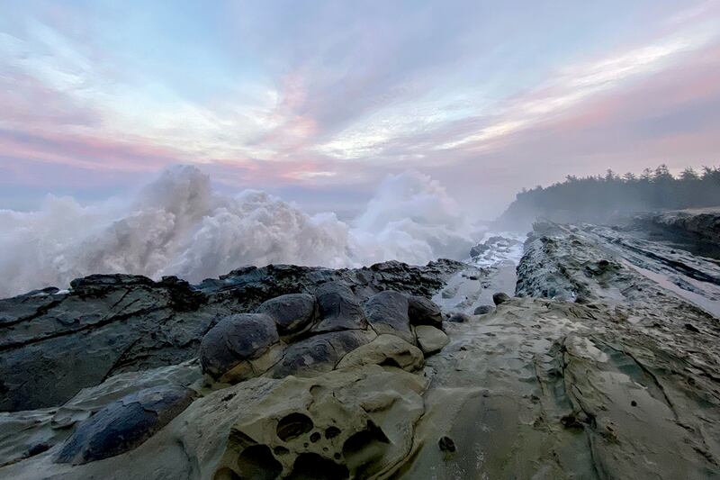
Cape Disappointment
Difficulty: Parks Scare Me
Distance: 2.5 miles
The name certainly doesn’t inspire much confidence. But the “disappointment” here has nothing to do with this promontory’s views. In fact, a good rule of thumb for destinations along the Pacific Northwest coast is, the more dubious the name, the more breathtaking the view—see Devils Punchbowl or Cape Foulweather. Often, the boiling bay or precarious peak in question earned that distinction because the seascape is so stunning it presents a hazard.
And Cape Disappointment is no different. The headland where the Columbia River meets the Pacific Ocean is one of the most treacherous bar crossings in the world. It was slapped with its label by English captain John Mears, who sailed near the cape in 1788, couldn’t find the river’s entrance, assumed it was a bay and called the whole mission a bust.
Whatever sort of deterrence the name had for early explorers, visitors today aren’t fooled. Campsites and picnic tables fill quickly on summer weekends, but even in winter, the site beckons plenty of storm watchers. To find the best views of waves slamming against the rocks, walk to the state park’s Lewis and Clark Interpretive Center rather than opting for the easy drive.
From the Cape Disappointment Trail, push up a fern-lined hill that spills out onto a small bluff above Waikiki Beach, typically covered in a tumble of driftwood. About a half-mile in, you’ll spot signs of human-made structures that have long been obsolete. These are the remains of Fort Canby, established in the mid-1800s as a harbor defense for the Columbia and maintained until the end of World War II. You’re free to use the old gun batteries as an archaeological playground, but do so with caution—the dark corners and rusted, doorless hinges can trip you up if you’re not paying attention.
If there is any sort of actual letdown on this hike along Cape Disappointment, it’s that the Coast Guard cut off trail access to the oldest operating lighthouse in the Pacific Northwest. But you still get a stunning perch at the interpretive center from which to view the weathered structure. Now you’re just shy of the southernmost point on Washington’s coastline, and on the edge of a continent that feels like the end of the world. The swirling river and pounding surf below won’t let you soon forget that last part. ANDI PREWITT.
Cape Perpetua
Difficulty: Parks Scare Me
Distance: 1 mile
Most hikes make you work to reach the attraction, whether that’s water cascading down a rock face hidden deep in the forest or a stunning 360-degree view from a mountain’s summit. But if you happen to be driving by Cape Perpetua at the right time of day, you can spot one of the headland’s most dramatic spectacles from the seat of your car.
During high tide, and whenever storms push onshore, the Spouting Horn shoots seawater dozens of feet into the air, making the explosion of spray and mist visible from Highway 101. The sight must have caused more than a few drivers to hit their brakes—a parking lot sits on the west side of the road for curious onlookers. But the 2,700-acre scenic area and its wealth of remarkably unique geological features demand to be explored beyond the boundaries of the rest stop.
Start at the Cape Perpetua Visitor Center (closed due to the pandemic, but its parking lot and restrooms remain open) and take the paved Captain Cook Trail, which winds slightly downhill through thickets of salal umbrellaed by spruce. After using an oversized culvert to tunnel safely under the highway, you’ll spill out onto a cliff overlooking one of several narrow coves, where waves work themselves into a foam by repeatedly slapping against ancient lava formations protruding into the Pacific. Veer left and, in a third of a mile, you’ll reach the ocean geyser. Formed when the sea’s surges widened a fracture in Cook’s Chasm, the horn spouts skyward when the surf funnels enough air and water into the cave, building pressure that eventually needs to be released. In other words, it’s Oregon’s Old Faithful.
Don’t miss nearby Thor’s Well, another geologic anomaly where water appears to go down rather than up. The collapsed sea cave looks like a bottomless sinkhole, constantly filling and emptying like a drain in the world’s largest bathtub. ANDI PREWITT.
Shore Acres State Park
Difficulty: Dirty Boots
Distance: 1.4 miles
Thanks to the jutting sandstone rock formations along Shore Acres State Park and the way the tides interact with them, the Coos Bay area has become a mecca for storm watchers from across the country. When conditions are right, swells can create crashing walls of water over 100 feet high. If you’ve ever seen photos on social media of water exploding skyward at the coast, odds are it was at Shore Acres—home to the largest, most intimidating wave breaks in the Northwest. Find yourself there at the right time, and you’ll be treated to a tangible display of Mother Nature’s power that’ll have you pondering your place in this world.
However, the Sunset Bay and Shore Acres state parks area has a lot more going for it than crashing waves and a scenic coastline. The park is home to, among other things, a top-tier botanical garden and a strikingly beautiful 1.4-mile loop hike. To pick up the trail, begin your trek about a quarter-mile past the entrance to Sunset Bay State Park. The path leads directly to a cliff-edge view of the bay and Cape Arago Lighthouse in the distance, before bending back into the forest. This pattern continues as the trail meanders toward Shore Acres, delivering a number of life-affirming views, then skirts along a geologically interesting stretch of waterfront before arriving at the observation building at Shore Acres State Park. To leave, use the broad path on the left that enters the forest, turning right at a junction for a short climb to the trailhead. ADAM SAWYER.
Hard Freeze
Mirror Lake to Tom, Dick and Harry Mountain
Difficulty: Weekend Warrior
Distance: 7.7 miles
There’s a good reason why the trailhead to Mirror Lake looks as intimidating as a Best Buy parking lot on Black Friday. Just as deeply discounted flat-screens hold near-universal appeal, this hike possesses almost every attribute an outdoors enthusiast seeks: a crystal-clear lake, awe-inspiring views of the state’s highest summit, and trails that vary in difficulty to satisfy a variety of ambitions. But if the throngs of visitors in spring and summer have kept you away from Mirror Lake, winter ushers in more solitude.
A trailhead reconfiguration in 2018 brought some much-needed order to the precarious parking situation on the shoulder of Highway 26, and a lengthened trek to the pool of water, though you’ll hardly notice during your approximately 2-mile walk there. As you cross several creeks, remember to thank a Forest Service worker. They helped install 10 new bridges that were airlifted in during the route remodel.
Once you reach the lake, hang a left for a tour of Mirror’s circumference. The iconic view of Mount Hood admiring its own handsome reflection can be found at the end of a boardwalk on the south shore, but the glacial circle has likely frozen over by now. Still, nature’s skating rink stuns with its own unique beauty found in alternating shades of blue, silver and stone.
For a photo opp that hasn’t appeared in every hiking guide, wall calendar and Instagram feed, continue up a trail to the right of the lake. You can see your destination rising in the distance: Tom, Dick and Harry Mountain, but unlike its name suggests, not everyone does this segment. In fact, you could end up tackling the two long switchbacks alone, so be sure to bring microspikes to attempt this ridge if you’re not already in snowshoes at this point. Once at the top, you’ll stare down at a pocket-sized mirror—an odd perspective given how large it felt just a short time earlier. ANDI PREWITT.
Tamanawas Falls
Difficulty: Dirty Boots
Distance: 3.5 miles
One of the best bang-for-the-buck hikes around Mount Hood, the Tamanawas Falls Trail is a major draw for waterfall hunters. The well-graded, 3.5-mile round-trip route showcases a sublime patch of exemplary mountain landscape complete with a pristine creek and dense forest—the coup de grâce being the broad, 110-foot Tamanawas Falls. At a little over 500 feet of elevation gain, it’s a good chunk of exercise but not exhausting. It’s a splendid hike in summer or fall. In winter, however, the amphitheater that encompasses the cascade is transformed into a breathtaking frost palace.
The trek leads down to a bridged crossing of Hood River’s East Fork. Take a right and ascend to a canyon viewpoint. The trail drops to a junction where you’ll stay left, cross another bridge, and arrive at the falls. Massive icicles that take on the size and appearance of an inverted crystalline forest flank the falls on either side, making the snowshoe trip an entirely unique endeavor. The boulders of Cold Spring Creek are transformed into snow-covered islands of white—winter breadcrumbs leading snowshoers to and from the falls. ADAM SAWYER.
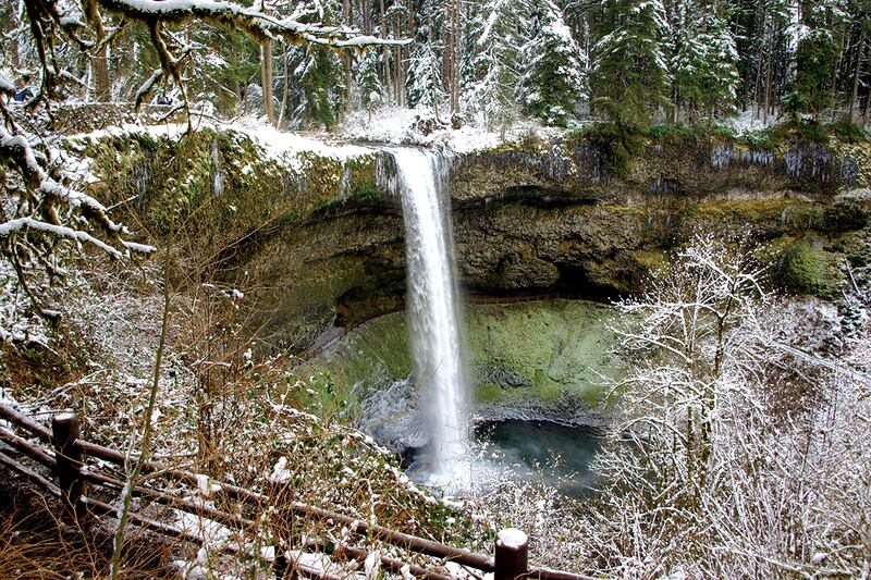
Silver Falls State Park
Difficulty: Parks Scare Me to Weekend Warrior, depending on route chosen.
Distance: Up to 7 miles
One of the crown jewels of the Oregon State Parks system, Silver Falls is hardly a secret. In fact, if you visit on any given sunny summer afternoon you’ll likely be hiking butt to gut with hundreds of your nature-loving neighbors. And who’s going to blame you? With 10 named and iconic waterfalls, swathes of old-growth forest, and a dramatic volcanic landscape, its popularity is more than justified.
But as with almost any of the state’s well-loved hiking spots, winter tends to mitigate visitation, luring those who are truly in it for the love of the game. That said, Silver Falls State Park is easily the best spot for wintry waterfalls in the Willamette Valley, and anyone who is properly prepared should be encouraged to visit when the property is blanketed in snow. The scene is surreal when the eerie quiet only amplifies the sounds of cascading water, and the crackling of ice echoes through distant canyons.
It’s a big park, and the extent of your explorations will be guided by road and trail conditions. It’s not unusual, for example, for certain sections of the Canyon Trail or steep, paved segments of the Rim Trail to be closed when things ice over. But large sections of forested paths and most or all of the major viewpoints tend to remain accessible—in particular, viewing areas at South Falls, North Falls, and pullouts along the road between the two. ADAM SAWYER.
Salt Creek Falls
Difficulty: Dirty Boots
Distance: 4.4 miles
Just steps from the trailhead, the views overlooking Salt Creek Falls and its enormous canyon are worth the Sno-Park permit price of admission. Because of its location near Willamette Pass, the area sees plenty of snow and ice in winter. And, at an impressive 286 feet, Salt Creek Falls is one of the tallest accessible waterfalls in the state. It’s like those wintry Multnomah Falls photos you see, but on steroids. In addition, the 4.4-mile, 400-foot elevation gain loop visits another unique beauty, Diamond Creek Falls, a cascading carrot to lure you beyond the overlook.
From the Salt Creek Sno-Park, snowshoe down the road toward a fenced observation area beyond an interpretive kiosk. After you’ve taken in the view, go back toward the kiosk and begin the loop by heading upstream about 300 feet to a signed trail. Turn right, walk past a picnic area and carefully cross Salt Creek on a footbridge, continuing into a frosty forest populated by snow-burdened boughs of Douglas fir and Western hemlock. Follow the blue diamonds to a junction leading down to Diamond Creek Falls. Continue straight another 350 feet and you’ll arrive at the upper viewpoint. The veiling falls spread wide and descend 120 feet over basalt steps and fissures. Take a left at the junction and enjoy an easy descent back. ADAM SAWYER.