Belski's Blog - Parts of the area in a limited tornado risk today
This includes Louisville
Advertisement
Belski's Blog - Parts of the area in a limited tornado risk today
This includes Louisville
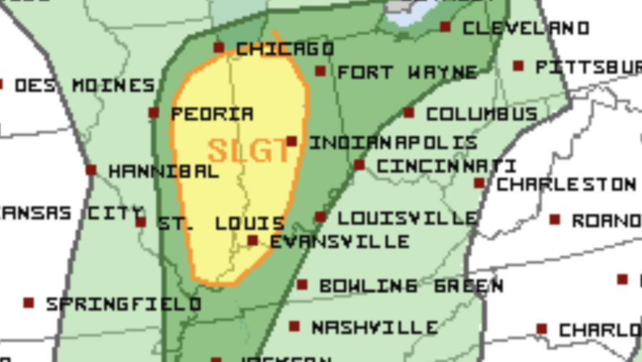
Updated 1:45 PM Sunday, May 17......The Storm Prediction Center has a risk for severe storms this afternoon and evening for parts of the Ohio Valley.Yellow is a SLIGHT RISKDark green is a MARGINAL RISKLight green is a thunderstorm chanceLouisville is on the edge of the marginal risk or level 1out of 5... which also covers all of southern Indiana and in Kentucky: Meade, Breckinridge and Grayson counties.Here is the tornado risk:The 2% or green area covers all of the local locations in the Marginal Risk. This includes Louisville. There is a limited risk for a small, brief tornado.The 5% area for tornadoes includes Indianapolis, Evansville, Terre Haute and Lafayette in Indiana.====Here is the damaging wind risk:Areas rare mainly in a 5% risk. Very localized if anything around here.The Slight risk for severe storms is the area that is covered by the 5% tornado risk.====At 1:45 PM the satellite shows the spin of the low pressure over Iowa. Areas that are getting sunshine from west Kentucky into Illinois stand the first chance for severe storms. If some clearing can occur along the I-65 corridor, then the thunderstorm coverage would be higher.======The HRRR short range computer model updated each hour has a future radar for 7:00 PM this evening of some severe storms across eastern Illinois.As the storms move east they are forecast to weaken tonight.======The 3K NAM has about the same location at 7:00 PM for possible severe storms.The NAM also has the weakening trend as they move east tonight.=======The SPC is keeping the Marginal Risk as far east as Louisville for now in case the weakening trend is slower than the computer models show.
Updated 1:45 PM Sunday, May 17......
The Storm Prediction Center has a risk for severe storms this afternoon and evening for parts of the Ohio Valley.
Advertisement


