National Geographic: Railroad Legacy Map of the United States in gift box Wall Map (Poster Size: 36 x 24 inches) (National Geographic Reference Map)
Publisher: National Geographic Maps , 2013
Edition: Unknown
Language: English
About the book
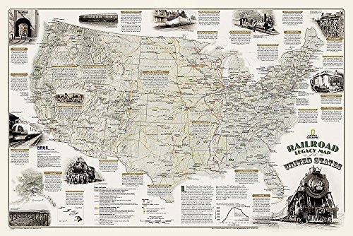
National Geographic's new Railroad Legacy Map of the United States illustrates the many ways railroads have impacted the nation and shaped people's daily lives. From the creation of time zones still used today to the contributions to the country's economic and industrial development, America's railroad legacy is interwoven with the growth of the United States in the 19th and 20th centuries and of the century to come.
The map portrays the routes of today's seven Class 1 (major) railroads, Amtrak's passenger routes, as well as those of the more than one hundred Class 1 railroads that ran in 1920 when five percent of the nation's work force—more than 2 million people—were employed by these lines. The map also highlights present-day and 1920 rail hubs along with text and illustrations of key events in America's railroad history such as the opening of New York City's Grand Central Terminal in 1913 and the last Class I line to employ steam locomotives in 1960. Notable sites such as tunnels, train spotting locations, and railroad museums are also included on this map.
The map is packaged in a full color box that is perfect for gift giving. The box includes details about the map with its size and scale as well as a large section of the map that displays the cartography found inside.
- Map Scale = 1:6,040,000
- Sheet Size = 36" x 24"