At a Glance
- Locally over 7 feet of snow buried the Buffalo Southtowns the week before Thanksgiving 2014.
- There were 14 fatalities with this storm, and thousands of motorists were stranded on snow-covered highways.
- Side streets in the Buffalo Southtowns remained choked with feet of snow days after the storm.
Five years ago this week, an epic lake-effect snowstorm crippled parts of the Buffalo Southtowns in western New York with over 7 feet of snow and illustrated the dangers associated with these types of snowstorms.
"There were 14 fatalities with this storm, hundreds of major roof collapses and structural failures, thousands of stranded motorists and scattered food and gas shortages due to impassable roads," the National Weather Service in Buffalo wrote in a post-storm summary. "Numerous trees also gave way due to the weight of the snow, causing isolated power outages."
(PHOTOS: Lake-Effect Snow Hammers Western New York)
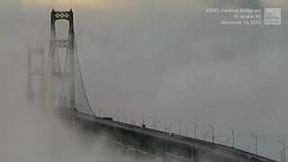
A 132-mile section of the New York State Thruway – known by locals as "The 90" – from exits 46 through 61 was shut down for several days. A stretch of the Niagara Thruway (Interstate 190) southbound from Niagara Falls (exit 16) to the Interstate 90 interchange was also closed.
Western New York dealt with two periods of thundersnow, both late Nov. 17 into Nov. 18, then again late Nov. 19 into Nov. 20, when a second major lake-effect snow event set up over nearly the same area and compounded rescue and recovery efforts. Snowfall rates were estimated as high as 6 inches per hour at times.
(MORE: What Is Lake-Effect Snow?)
Localized snowfall totals from the combination of the two storms peaked at over 7 feet, with many areas south of Buffalo buried under 3 to 4 feet of dense snowpack by the end of the event.
Here were the reported snow totals from both rounds of lake-effect snow in western New York between Nov. 17 and Nov. 21, 2014:
- Cowlesville: 88 inches
- Lancaster: 74 inches
- Orchard Park: 71 inches
- Wales Center: 69.3 inches
- West Seneca: 52.5 inches
- Buffalo International Airport: 16.9 inches
- Tonawanda: 7.9 inches
Side streets in the Buffalo Southtowns were choked with feet of snow days after the storm.
This snow prompted the National Football League to move a Sunday afternoon game between the host Buffalo Bills and New York Jets to Detroit on Monday night. The Buffalo Bills estimated 220,000 tons of snow needed to be removed from then Ralph Wilson Stadium (now New Era Field) in Orchard Park, enough to fill the team's practice facility eight times.
Was this the worst storm in Buffalo area history?
Tom Niziol, former winter weather expert at The Weather Channel, said a five-day blizzard in January 1977 hammered all of western New York, including the city of Buffalo, stranding hundreds in their vehicles. Twenty-nine people lost their lives in that storm. Many were asphyxiated in their cars or died from exposure.
In 2014, two factors combined to yield the extreme snowfall totals in areas of the Buffalo Southtowns.
First, wind directions remained fairly constant. That meant lake-effect snowbands hammered the same areas for a prolonged period of time.
Second, the air blowing over the lake was the coldest for that early in November since 1986. The large temperature difference between the relatively mild Lake Erie waters and the air above create an unstable atmosphere, which allows air to rise more quickly, and therefore, generate snow more efficiently. Snowfall rates were estimated at 4 inches per hour in the snowbands east of Lake Erie.
(MORE: The Great Lakes' Amazing Lake-Effect Snowfall Records)
Research has shown that November storms produce the highest amount of precipitation for lake-effect events. Because the atmosphere overall is warmer in November compared to January, it is able to contain more water vapor, which in turn produces more snowfall.
Elsewhere that week, parts of western Lower Michigan picked up almost 30 inches of snow. Through 8 a.m. EST on Nov. 20, 2014, Gaylord, Michigan, chalked up its heaviest three-day snowstorm on record, with 29.6 inches of snow since the morning of Nov. 17.
Grand Rapids, Michigan, set a new November monthly snow record, topping the old November record from 1895 (28.2 inches).
The snow-weary Upper Peninsula of Michigan and far northern Wisconsin also got its share of heavy lake-effect snow, with over 50 inches reported in one northern Wisconsin town.
(MORE: Over 50 Inches of Snow Blankets Wisconsin Town)

Marquette, Michigan, went on to set a new November monthly snowfall record in 2014, with 53 inches piling up by month's end. An average November in Marquette brings 24.5 inches of snow.
Winds also gusted over 50 mph at times in the Keweenaw Peninsula of the Upper Peninsula early Nov. 18.
The Weather Company’s primary journalistic mission is to report on breaking weather news, the environment and the importance of science to our lives. This story does not necessarily represent the position of our parent company, IBM.


