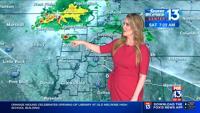


MEMPHIS, Tenn. - We are continuing to watch a severe weather and tornado outbreak unfold in portions of Texas, Oklahoma, Kansas and Missouri tonight.
After multiple days of strong storms and destructive hail and tornadoes the cold front will be picking those storms up and moving them to the East over the next 24 hours.
We will see a chance for some storng storms, but nothing like they saw in the plains the last 48 hours.
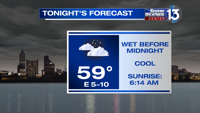
As for the weather this evening. Lows will stay warm, down into the middle 60s for much of the region. It will remain very humid.
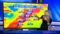
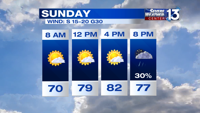
Mostly clear skies will continue through much of the day tomorrow. Sunday will feature highs in the middle 80s and very breezy conditions. Winds between 20-25 miles per hour gusting to 30 throughout the day. Some clouds increase in the afternoon.
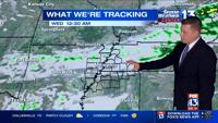
After 8pm Sunday the front begins to move into the region. Depending on how far the front moves across the area before stalling will determine how long the storms last and how much of a severe weather threat we will see.

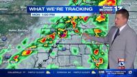
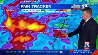
Storms possible between 9pm and 6am on Sunday night into Monday. Then some pop up showers and thunderstorms will be possible along and East of the Mississippi river. Some gusty winds and small hail may be possible with these storms. Heavy rain looks to be a growing concern. Between 1-3 inches of rain could fall within training thunderstorms across the region Sunday afternoon through Monday.

HERE IS WHAT YOU NEED TO KNOW:
- Staying mild and muggy overnight
- Warm and windy Sunday with highs in the middle 80s
- Storm chances Sunday night into Monday
- Severe weather possible, still uncertainties
- Staying warm and unsettled this week
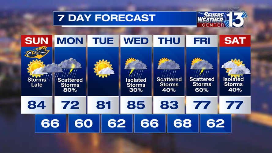
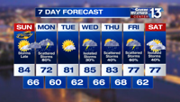
HERE IS THE FORECAST:
TONIGHT: Mostly clear and staying mild. Temps falling into the middle 60s across the region. Breezy. Low of 66 degrees. Winds S 10-15 G30.
SUNDAY: Mostly sunny during the day. Breezy. Highs approaching the middle 80s by the afternoon. Warm and muggy. Increasing clouds late in the day with a line of strong and gusty thunderstorms overnight and into Monday morning. Heavy rainfall along with gusty winds and small hail are possible. High of 84 degrees. Winds S 15-20 G30.
MONDAY: Scattered thunderstorms will be around overnight and into the morning. More scattered storms could stick around throughout the day. Highs will be in the 70s due to rain and cloud cover in the area. It will remain warm and breezy. Storms end by the evening. Gusty winds and heavy rain are the main threats. High of 72 degrees. Winds S 10-20 G30.
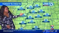
TUESDAY: Partly cloudy. A mixture of sunshine and some clouds will allow temperature to rise back into the lower 80s by the afternoon. No chance for rain. High of 81 degrees. Winds S 5-10.
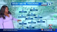
WEDNESDAY: Starting off dry and warm. Increasing chances for scattered thunderstorms by the afternoon and evening. No severe weather expected. Some heavy rain could be possible. High of 85 degrees. Winds S 5-10.
Download the FOX13 Memphis app to receive alerts from breaking news in your neighborhood.
Trending stories:
- 3 men charged in connection to deputy involved shooting, court reports show
- 3 men injured after shooting at Beale Street nightclub, police say
- Crash involving motorcycle leaves man with serious injuries, SCSO says
- Mid-South Most Wanted Fugitives