
Why are some places more popular for bicycle users than others? How important is infrastructure versus other factors such as proximity to destinations, connectedness to other infrastructure, and so on? What’s parts of town have the most bicycling hot-spots?
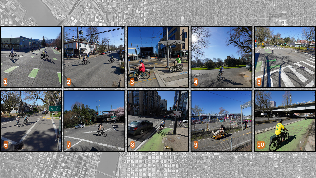
I’ve been poking around the 2023 City of Portland Bicycle Count Report and thought it’d be fun to share the top ten highest traffic locations. So on Sunday I grabbed my 13-year-old son and we visited all 10 locations. I got one of the spots incorrect so I had to roll over there this morning, but otherwise, all the photos (and forthcoming video) were shot on March 17th. These numbers come from a publicly accessible spreadsheet created by the City of Portland.
Check out the top ten below, peruse the area on the Google map, then ask yourself: why do so many people bike here?
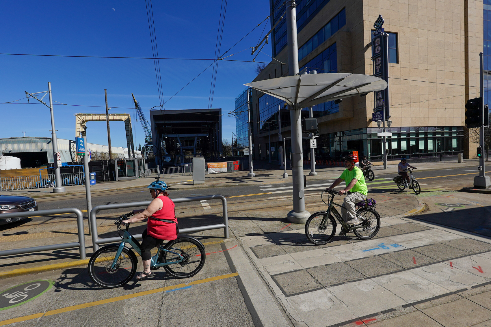
10. SW Naito at Morrison Bridge – 2,060 daily riders
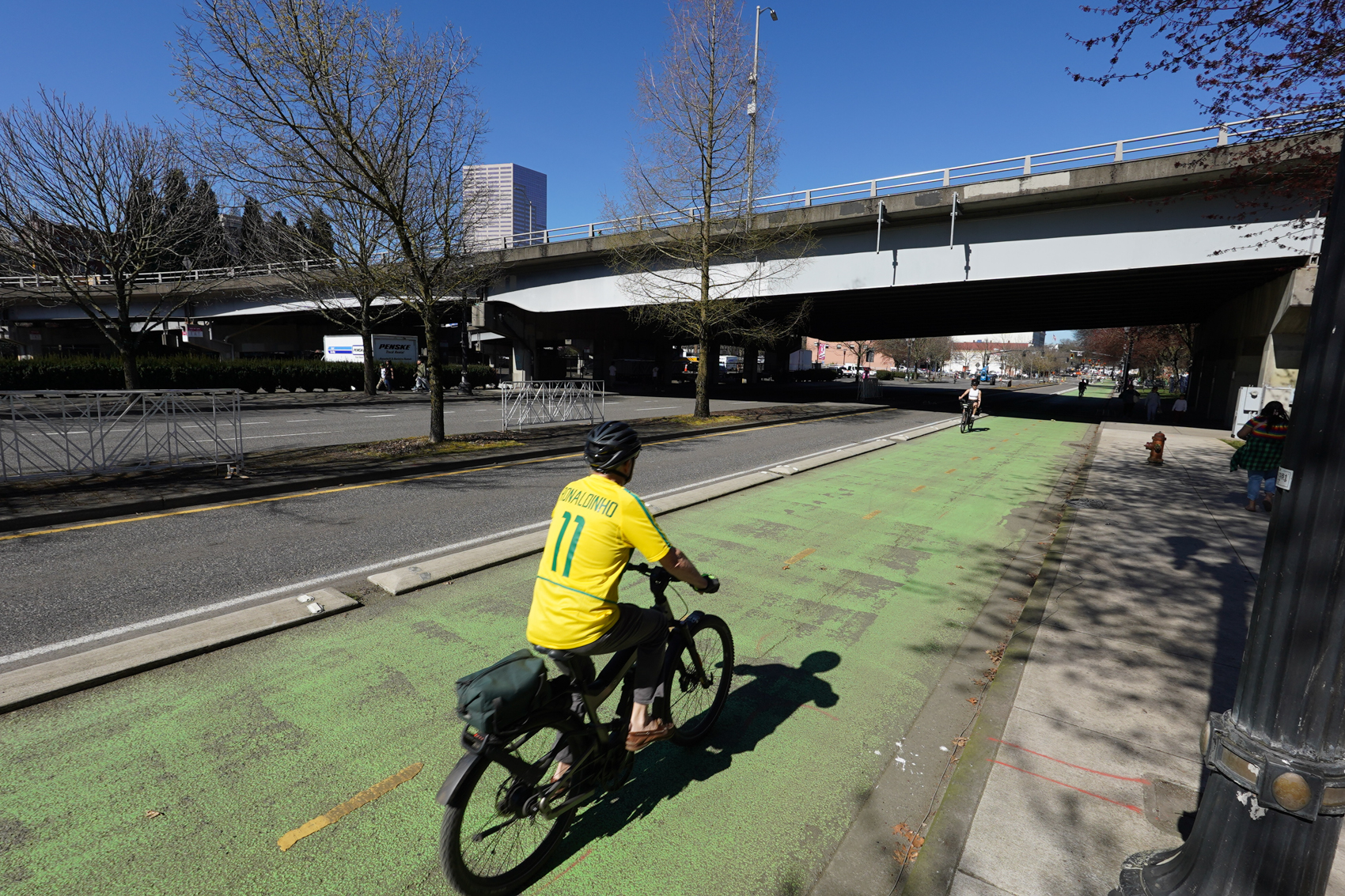
Since hardly anyone rides the Morrison these days, this number is definitely more of a reflection on Naito Parkway’s new bikeway than anything else. It’s a bummer the pandemic shifted so many folks out of the central city, because Naito is poised to carry much heavier volumes and the design has held up very well (except for the green color which is very faint in some locations). The spot near the Morrison Bridge is two directions for bike traffic and protected from one narrow travel lane by low curbs. A wide sidewalk gives folks on foot a place to be without getting in the path of bike riders. Given how much we love Better Naito, I’m glad to see it crack into the top 10.
9. SE Springwater Trail (S of Ivon) – 2,115 daily riders
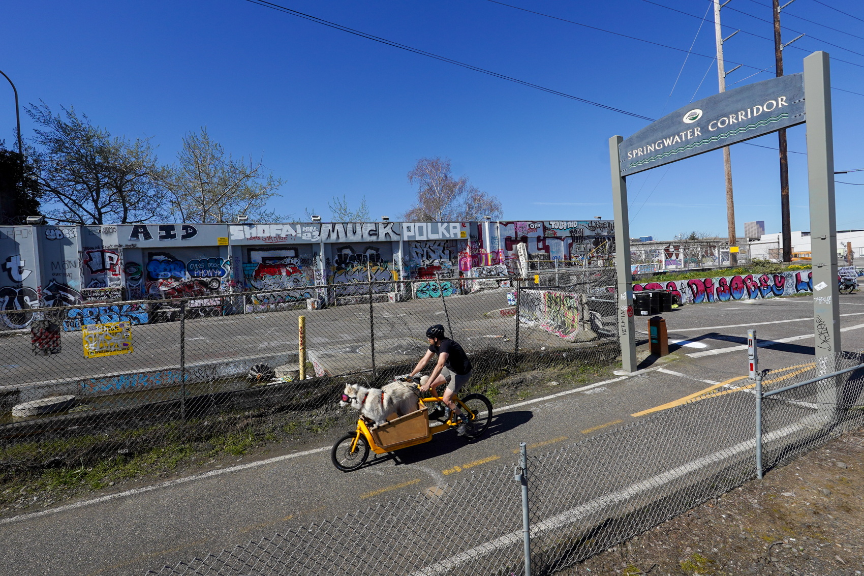
There are three Springwater locations in the top 11. The top-ranked spot is just a block or so north of this location, where the path meets SE Ivon Street. I bet Splendid Cycles (on the corner) is the only bike shop in town with two top ten traffic locations within a few blocks of its shop.
8. NW Lovejoy & 9th – 2,135 daily riders
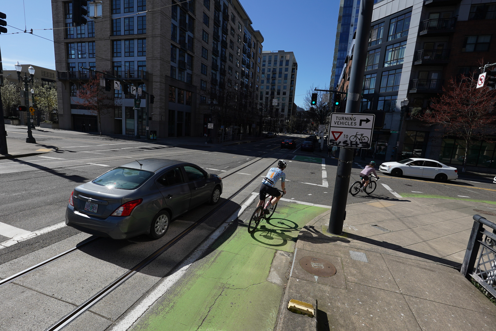
The only location in northwest, this is right at the bottom of the Lovejoy ramp that connects to the Broadway Bridge. The improvements of nearby greenways on Johnson and Marshall have certainly helped boost this number. This is a key route used by riders throughout the city who are headed to long rides in the West Hills, Highway 30, and beyond. It will be interesting to see how traffic changes once the Broadway Corridor project is complete.
7. N Interstate Ave/NE Lloyd Blvd & NE Oregon St – 2,140 daily riders
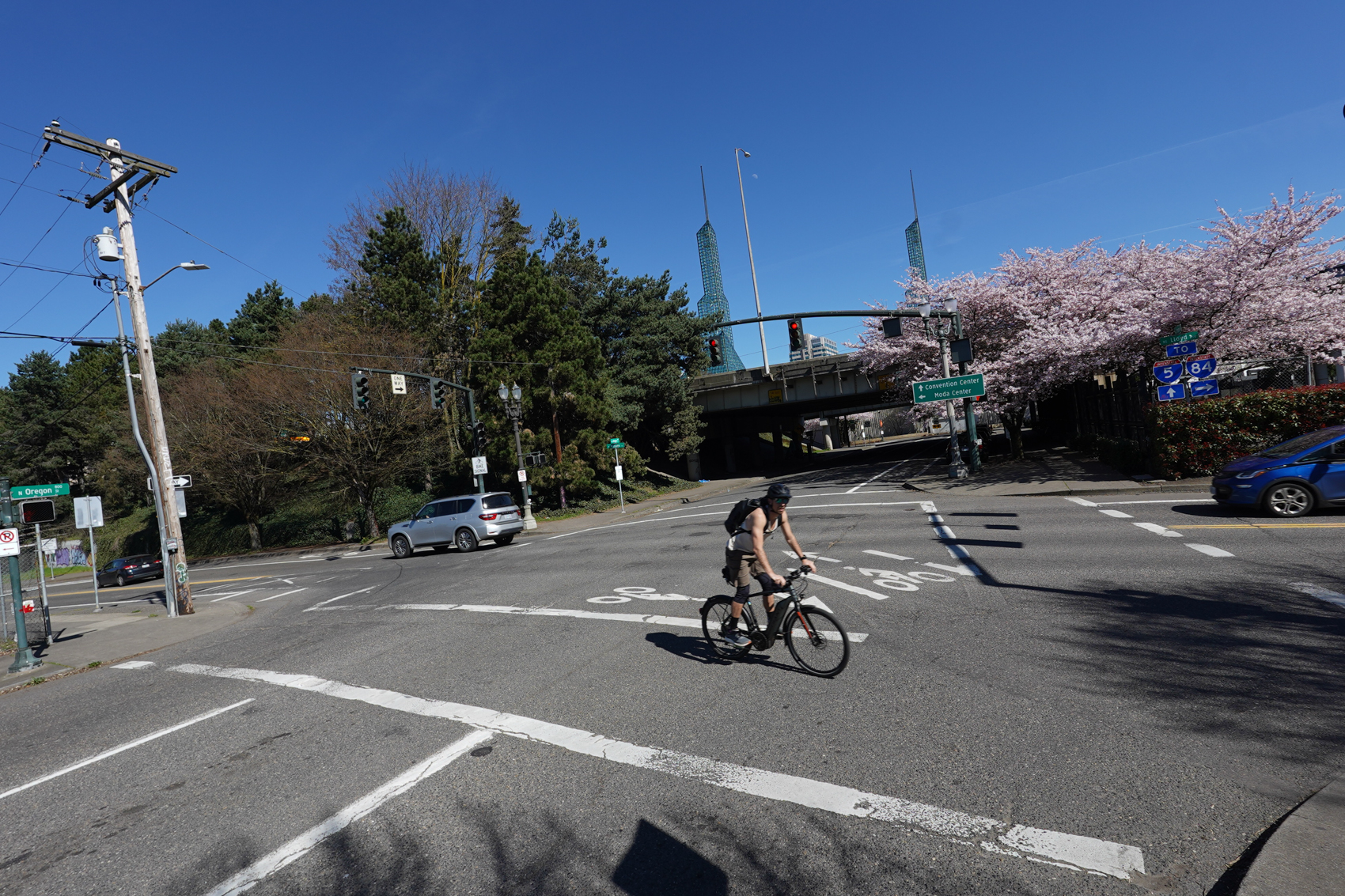
Peace Park! This location likely has a special place in everyone’s heart. It’s an iconic biking spot. Maybe it’s the cool bike traffic signal (imported from the Netherlands) or how you are straddling the Rose Quarter, the Convention Center, the Steel Bridge, and the Esplanade all at the same time. This is a part of a key connection between downtown and North Williams Ave.
6. SE Clinton & 34th – 2,190 daily riders
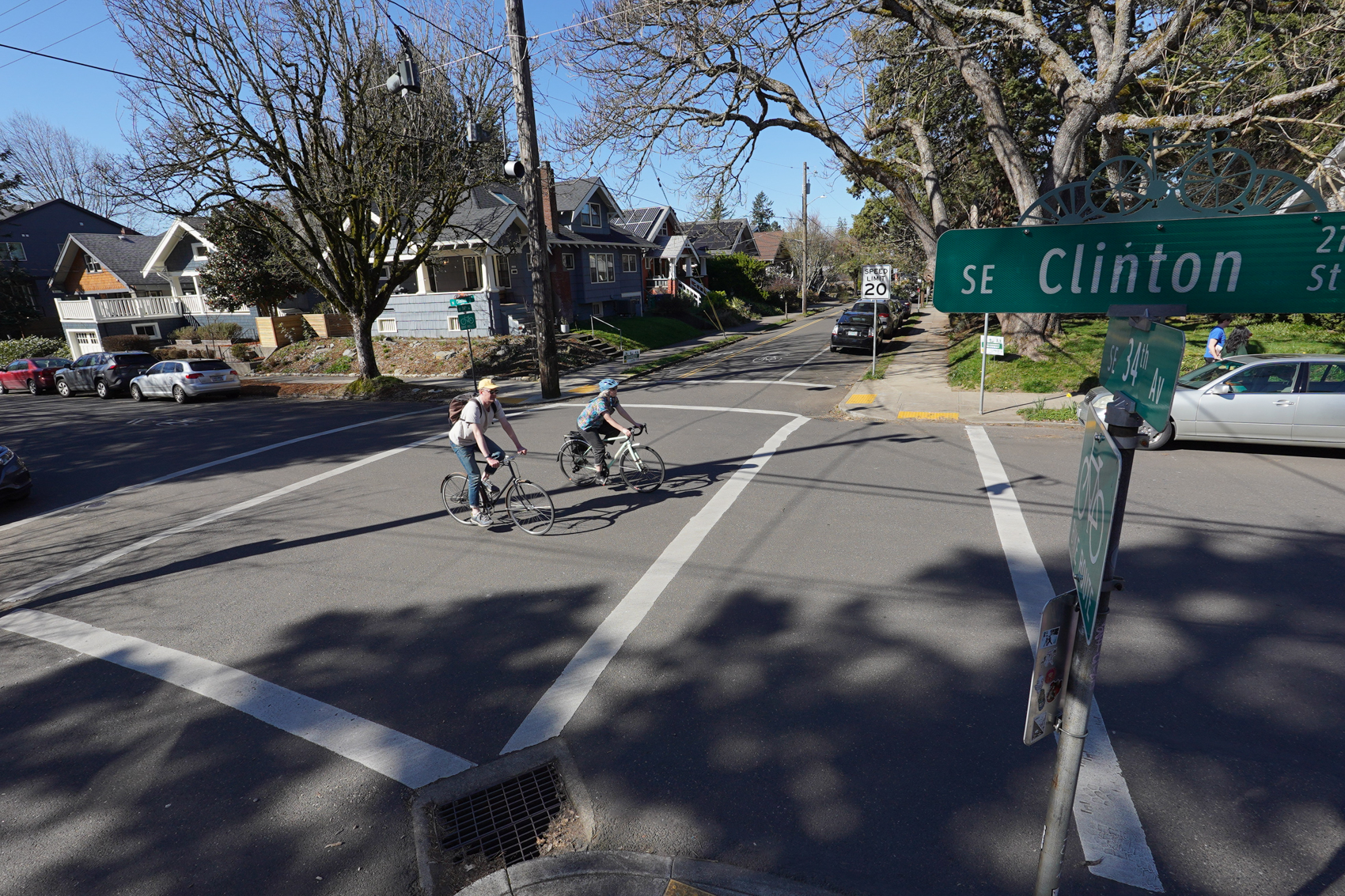
This is one of two spots in the top ten for the legendary SE Clinton St. neighborhood greenway. As my son and I biked to this spot he said, completely on his own, “This is a nice neighborhood, dad. It’s so quiet here.” There’s a market on the corner and it’s just one block from lots of cool stuff on SE Division. Recent traffic calming and diversion upgrades have made Clinton even better in recent years. Sit on this corner on a beautiful day and have your faith in Portland restored as bikers of all ages and persuasions roll past calmly.
5. N Williams & Russell – 2,245 daily riders
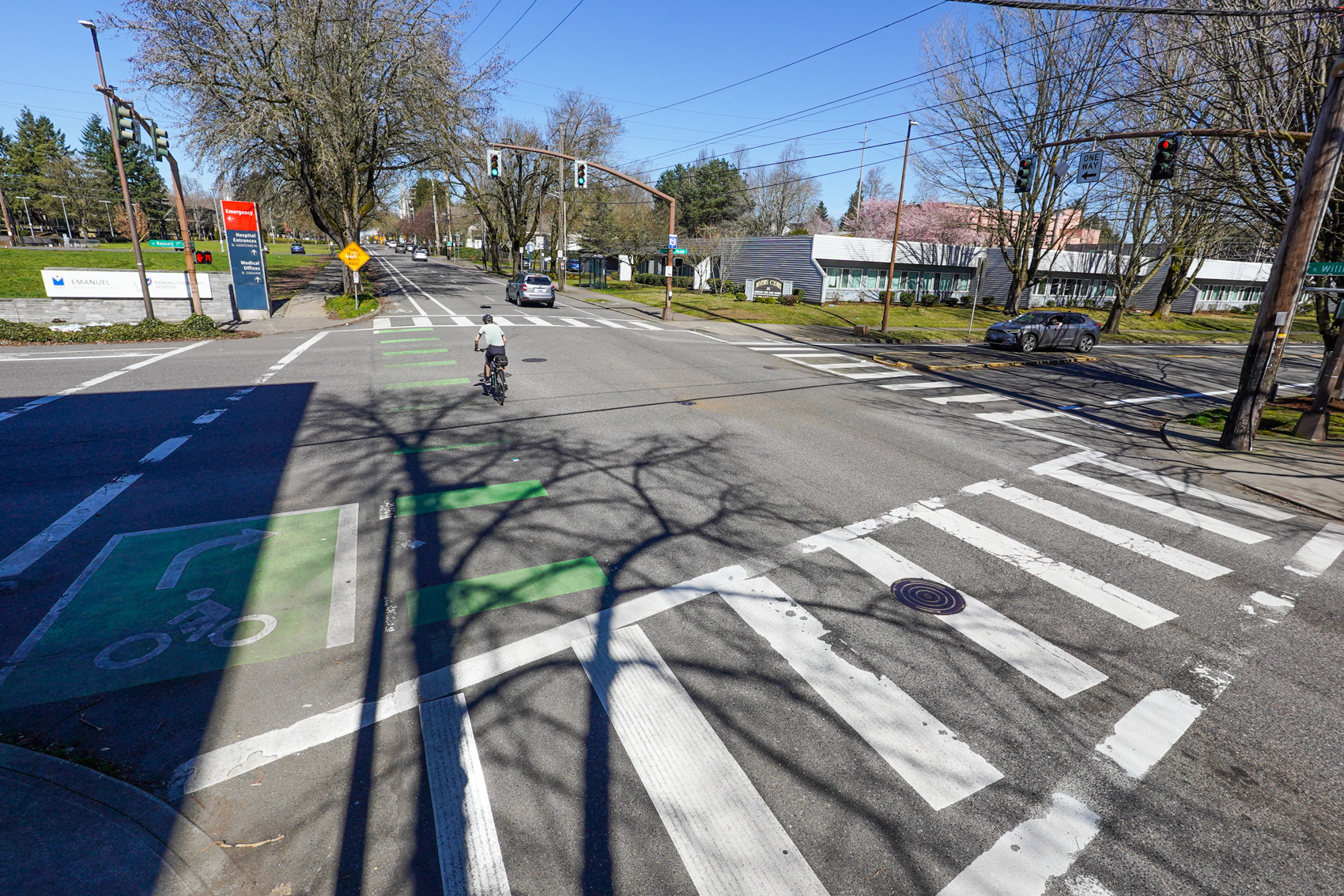
Of course Williams is in the top four. I’ve called Williams the best bicycling street in Portland and I still think it deserves that title. It’s a very rare example of a commercial district street with a dedicated bikeway. This is a few blocks south of the busy sections of the street, before too many riders have turned off. This might be the #1 spot in a few years once the Williams & Russell project is built.
4. SE Harrison & Ladd (Circle) – 2,375 daily riders
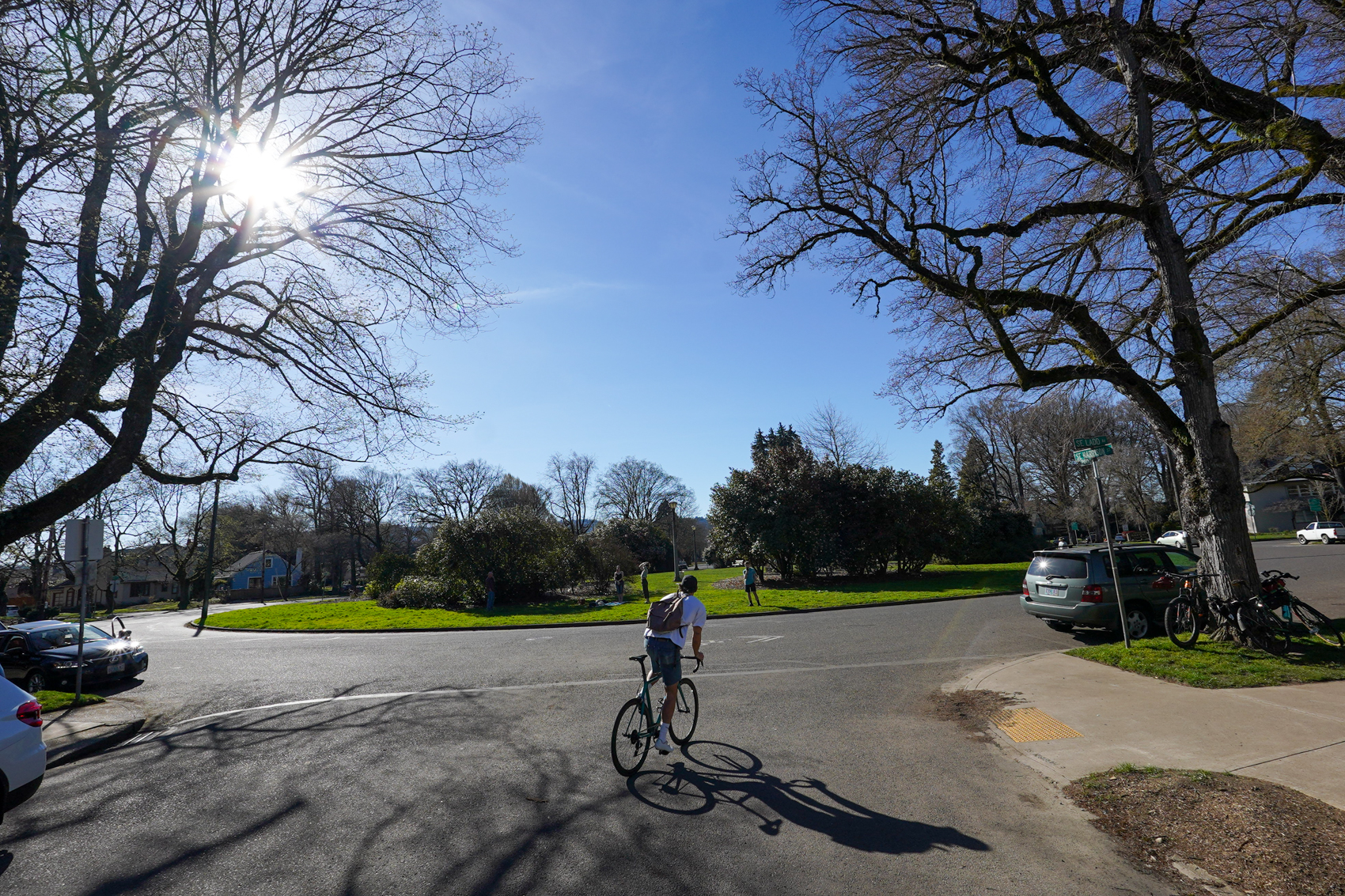
One of six southeast locations in the top ten, Ladd Circle Park is a highlight of so many great biking memories — from the humble commute to the zany Ladd’s 500. Maybe the most pleasant spot on this entire list. No dedicated bike infrastructure here, just organic traffic calming thanks to shared-lane markings, roundabouts, relatively narrow streets, and locals who know to always expect bike traffic.
3. S Moody & Gibbs – 2,455 daily riders
Smack dab in the middle of what I always think of as the Portland petri dish of urban planning, this location is eye-popping. Consider this: It’s adjacent to North America’s largest bike valet, Oregon’s largest employer, one of only two aerial tramways in the U.S., and a streetcar line. If you haven’t watched traffic here from the tram or Gibbs Bridge elevator, you are not a true Portland transportation nerd. (Yes I realize it was not ideal to to visit this on a Sunday when it’s pretty dead.)
2. SE Clinton & 26th – 2,625 daily riders

The only reason I don’t give Clinton the title of “best bike street” is because it doesn’t have a dedicated bike lane. But I should probably reconsider that. With two spots on the top ten, Clinton is really showing the power of PBOT’s greenways to attract bikes. This spot at 26th is always bustling and full of life with the iconic Clinton St. Theater, great bars and restaurants, and even a bike-friendly physical therapy office (hi Kevin!).
1. SE Caruthers & 4th – 3,415 daily riders

The only spot to break the 3,000 rider barrier this shows the power of the carfree paths on the Esplanade and Springwater to attract riders. Three spots in the top 11 are within two blocks of this spot. I can’t wait for the day when this location isn’t on the top 10 list because we’ve completed the Esplanade-Springwater path connection and folks don’t have to ride on surface streets here. It’s notable that this is #1 without any high-quality bike infrastructure (I realize it’s a gap between two carfree paths). There’s only paint, but it feels safer because it’s such a popular route.
What do you think? Any surprises? What can we do to replicate these conditions in more places?
Note: Below is an excerpt from the counts report about how PBOT got these numbers:
“These summer counts were conducted by 114 volunteers between June 6 and September 28 on either a Tuesday, Wednesday, or Thursday. Volunteers counted during the two-hour peak time for people biking. At most locations that is 4-6 p.m. Locations on one-way roadways going into the City Center were counted during the a.m. peak, from 7-9 a.m. Using a standard traffic engineering rubric, these two-hour peak counts are assumed to account for approximately 20% of all daily bicycle trips at each location, making it possible to extrapolate a full weekday estimate of the number of people biking at each site.”


I consider myself a pretty “cycle no matter the weather” type, but I avoid N Williams in favor of Rodney Ave because I’ve been left hooked too many times. Williams design farther north with the left turns thru the bike lane leaves me feeling very exposed and not safe.
Last fall I moved to a new office that was compatible with a homeward Williams commute as far as Going. I almost always take Vancouver southbound, but avoided Williams all winter if I was headed home any time close to rush hour. Maybe back when there were more bikes on Williams, I’d have felt safer with the sections of traffic mixing around New Seasons. But I don’t – I turn onto Tillamook and head north on the 20s bikeway instead.
this highlights how badly PBOT failed when they crashed and burned the 7th street bikeway project. When they walked away from 7th, they have also cancelled the Blumenauer bridge instead of continuing to half-ass it.
N. Williams is my least favorite bike lane in all of Portland. Motorists consistently speed 10-20 above posted limits and red lights and stop signs are only suggestions it seems. All of my closest calls during my 15 years of bicycle commuting have come on the stretch between Moda and N. Killingsworth. This arterial needs a true protected lane, bike signals, and better enforcement asap.
Fun post! Looks to me as if most of these just happen to be chokepoints, but I’d say the big Clinton numbers are the direct result of the diverters won there by BikeLoud in its first outing 10 years ago or whenever that was.
As for 26th & Clinton, I’d say the bike lanes that matter most to the counts there seem like the north/south routes on 26th across Powell.
Sad that these are the top spots in the city, yet their photos portray ghost towns. Compare images from UC Davis in Davis, CA, where people really do get around by bike: https://www.google.com/search?q=uc+davis+bike&tbm=isch
Keep in mind these photos are from a few hours on one Sunday and we didn’t spend too much time at each spot. And yes, our bike traffic is way down – 32% from pre-pandemic levels. I don’t think that’s necessarily “sad”, it just is what it is.
Also… about Davis. It’s a small town dominated by a big college with a major legacy around cycling on campus so it has an artificially high number of bike riders. I don’t find it a to be a helpful comparison for Portland.
So, in order:
This is a story with a longer shelf life. Taking the time for a better photo methodology might have been a better deal than one that requires such apologetics.
Yes, I know about Davis. I went to school there and ran its bike safety outreach (how to ride when you just moved in from someplace where people don’t ride). Later I lived in PDX for 18 years, until the pandemic was well underway. Folks in PDX might be under the impression that PDX people get around by bike, but only if they haven’t lived in Davis.
I guess you are free to “find” whatever you want about the comparison. For its part, the LAB found both Portland and Davis to be “platinum” — so to me, it’s on.
I say Portland built infrastructure on the assumption that Dutch-style culture (that looked so cool during their many field trips overseas) would follow — but it has not. Meanwhile, Davis grew up with bike-inclusive culture — even pre-war but especially post-war.
Takeaway for me: Build culture, not (just) infrastructure. Yes, putting a major university in a smaller town is one way to flood the zone with a culture of multimodal respect and tolerance. What would be some others?
But this is an idea seemingly beyond the grasp of decades worth of PBOT/ODOT/MultCo/Metro “planner” wonks with their scant repertoire of not much more than paint and wands. The photos accurately show the results.
It’s also important to not that these images are likely cherry-picked by Maus to show a few people cycling. When I bike through some of these spots the norm is to see no one else cycling.
On the other hand, the one I’m most familiar with (#3 S Moody and Gibbs) is often packed with people biking (and walking and on scooters) and the bike corral is swamped. It just depends when you’re there.
Focusing on the photos makes no sense. An intersection that a couple thousand bikes pass through in a day might often have no bikes in it, and never more than a few.
You might as well conclude that, based on several of these photos, more people bike than drive in Portland.
Yeah, #3 is often packed — because OHSU did inadvertently foster daily-get-around-without-a-car culture with its main campus having not much flat-ish land, and thus ruthlessly difficult and expensive staff/student car parking. That’s fair game, much like putting a major university (UC Davis) in a smaller town. (So that’s now _two_ ways to foster such culture. What are some more, instead of planners cargo-culting more paint and wands?)
As for focusing on the photos, message received: You feel the photos are low-value or even misleading. Methinks JM might beg to differ. Kinda running out of legs to stand on.
OHSU didn’t “inadvertently” foster a car-lite campus. I can’t find it right now, but I remember that there was an “OHSU Plan” in the early 2000s about traffic on the hill. And an OHSU parking district agreement with the Homestead neighborhood from about the same time. It was a well-thought out strategy for handling the topographical constraints. It even extended to offering to put speed bumps as far away as Humphrey, but the Humphrey neighbors, I’ve been told, declined the offer. The OHSU parking policy example should be followed by other employers.
OHSU didn’t “inadvertently “ foster the current South Waterfront bike culture. It was intentional, it’s taken 10 years, and there are paid OHSU staff whose job it is to maintain and grow it.
Kind of like Davis.
No Michael and Lisa, you are wrong (and apparently short-sighted). The reason any of the stuff you mentioned endured or even came to be is because the precursors to OHSU received free land in a canyon on a hilltop, in the late 1800s. That land acquisition was because the donating industrialists found the land unuseful; it was _not_ to foster getting-around-without-a-car culture (because it was before car dependency). Thus, that effect a century later has been inadvertent.
Think: Why _haven’t_ the efforts you mentioned arisen or stuck anywhere else? Isn’t one huge reason because they _don’t have_ “topographical constraints”?
If you’re going to go back centuries, the whole town, hell the whole damn country is inadvertent.
What’s the deal 360? You just itching for arguments?
No Lisa, it is not. Industrialists intentionally, not inadvertently, held and developed the useful land that lacked the “topographical constraints.” That intent helped create a market for the motorcar and has led to rampant car dependency in the U.S. But nice strawman. (100 years and change is not “centuries,” for one.)
What I’m “itching for” is to finally get beyond shallow “cargo cult programming” (see https://en.wikipedia.org/wiki/Cargo_cult_programming ) and acknowledge that installing superficial stuff on the road doesn’t foster a durable, dependable culture of getting around without a car.
What _does_ foster such culture is, yes, topographical constraints (inadvertent) that lead to scarce and expensive car parking, or having a smaller town be economically dependent on a major university (somewhat intentional). What are some other root, macro, upstream culture-fosterers that local governments could intentionally pursue, rather than continuing to cargo-cult away with paltry results?
Here’s one, though it would lack political will until climate change is much worse: Exclude or severely limit the number of gas stations within zones that planners could earn their keep by defining. Do the same for charging stations as EVs replace bronto-burners (because EVs are still fast, wide and distraction-filled).
“The reason any of the stuff you mentioned endured or even came to be…”
Um…wow.
I think there’s probably more than one reason. But let’s just let you win this one.
Eh, “cherry-picked” typically implies deceit, and that seems severe. But yeah, the photos in the story likely were picked because they were the least sad.
Comparing this article’s shots of Portland streets with the google results for “uc davis bike” images is meaningless.
Google “portland bike” images and you’ll see bike-focused images here much like your example:
https://www.google.com/search?sca_esv=fcb7a8fbd434909e&sxsrf=ACQVn0_fPWAr6KhWg65YzIRPkrhL6aubMA:1710819507474&q=portland+bike&tbm=isch&source=lnms&sa=X&sqi=2&ved=2ahUKEwjY9JGos_-EAxX2FTQIHbvhDq8Q0pQJegQIDRAB&biw=1920&bih=919&dpr=1
Alternatively, do some google street view searches of UC Davis and you’ll see images with few bikes that look much like Jonathan’s photos.
You are naive. At that link, the photos with more than a half-dozen riders in them are from _events_ on Portland streets, not people who happen to be doing their mundane daily getting around by bike in huge numbers — as in Davis. Two entirely different flavors of “culture,” but representative: It seems Portland can manage to occasionally signify, but Davis is day in, day out for real.
And yeah, sure, the Googlemobile could get some sleepy images of outer UC Davis streets — at, say, 8 a.m. on a Saturday.
But if comparing is “meaningless,” why did you attempt it? And _why_ exactly did you claim “meaningless”?
If you live in Davis…Congrats! If you don’t, maybe think of moving there!
1. A loop around the river between the Broadway and the Tilikum Bridges on or near recreational trails
2. Inner SE, but not central SE
3. Everyone fans out from Williams and Russell, somehow, yet I’m usually the first to turn off
I don’t understand this comment. What are you listing? It doesn’t seem to correspond to Maus’s list numbers.
I agree, Clinton is very nice and a great example of how greenways with good traffic calming and diversion can be pretty great places to ride. It helps that the hill isn’t *quite* as ornery as on Lincoln/Harrison one greenway up.
What could really make the connectivity in the area pop is some more diversion on 34th. It’s a narrow, residential street, but drivers are constantly cutting through and paying little attention.
I wasn’t almost in an accident on Clinton but a crazy minivan did blow through a stop sign right in front of me- I saw it all happening a mile away, so when I caught up to them & rode past them, they had their window down and I just said “nice stop!” and the driver FREAKED OUT screaming “don’t f*ing talk to me like that, I have f*ing kids in the car, you f*ing a**hole” and tried to hit me as I blew past them. luckily it was all just pretty funny to me but what a weird event. so yes, I agree, much more diversion would be greatly appreciated. I’ve also seen trucks blowing through the stop sign right by clinton theater which obviously is a well used path of travel both for bikes & peds. We take it for granted that it is “safe” because its a bike greenway but alas… anytime cars mingle with bikes, it isn’t truly safe for us 🙁
I love this; peak Portland; they’re not my kids; if having them makes you unable to follow traffic rules then you shouldn’t have had them. Drugs, kids, identity categories, so many excuses for not following traffic rules!
I ride Clinton at least 3x week in my commute from South Waterfront back to Montavilla. (I ride Lincoln/Ladds inbound in the morning). The section from 26th to Caesar Chavez is the most dangerous part of my commute – I saw a rider get hit there 2 weeks ago, and I’ve had many close calls. The problem used to be aggressive drivers using Clinton, but the good infrastructure has cut that way back. Now the problem appears to be drivers desperately searching for parking so they can access the businesses and restaurants on Division. They often don’t come to a complete stop or look for bikes before crossing Clinton. I still ride it and enjoy it, but I’m always on high alert through that section.
Completely agree with that assessment. Inattentive drivers looking for parking are probably the biggest issue I have with a lot of greenways. Ankeny from MLK-12th is a spot that comes to mind.
I think that those zones could mostly use good intersection daylighting. That would reduce a lot of conflicts.
I have the exact same commute. I find the Woodward and the high school traffic to be the worst part of that ride. I assume they can’t divert traffic off of it for school and emergency reasons so there’s a ton of cut-through drivers trying to save time by avoiding Division and Powell. I agree though that cross traffic is pretty bad and more daylighting would go a long way to help with it.
Agree – Woodward at beginning and end of school (or Tillamook bike route and Grant HS) are case-studies in why school zones are often the most dangerous places for cyclists and pedestrians.
does anyone know what time of day & year they do these counts? the link I saw doesn’t say… a november day is way different than a 75 degree April day….
Hi. This is from the report:
The “standard traffic engineering rubric” was created well over 20 years ago based on a bicycle commuter pattern that may no longer exist, and that in any case needs to be re-evaluated and re-calibrated periodically.
A better system would be 24/7 counts like they do on some bridges in Portland, or in many jurisdictions outside of Portland with infrared readers.
But then if the rubric is recalibrated, it brings into question how valuable previously-collected data (and results) really are – if they are off by a magnitude, doesn’t it downgrade PBOT’s counting methods?
They addressed this in their 2022 report.
So it appears to still be valid.
Thank you for the link. In the small print (page 29):
I’m surprised that 26th & Clinton made the list, but not 21st & Clinton. That intersection gets almost all the traffic from 26th & Clinton, but also a fair bit from 21st, which is a pretty heavily used bikeway in its own right.
It pains me to see the Springwater Corridor represent by a photo dominated by the chaotic graffiti of the vandalized cement plant. The Springwater trail, alongside the River, wetlands and lagoon provides a taste of nature and car free serenity. I frequently see deer grazing as I ride by. The Springwater is some of the best of Portland but the photo displays some of its worst. Way to bury the lead.
The photo locations correspond directly to actual count locations. This isn’t a choice i made.
I think it does represent it. There is nowhere I feel less safe in Portland than on the Springwater, there are fences on both sides so nowhere to run if you are on foot; I’ve been jumped there twice; if you’re stopping to enjoy the nature its quite often that you get the feeling you’re disturbing someone who is hanging out there.
What you say is true, but there are many people encountered who are not using it as a way to get around and don’t seem to appreciate the nature in the same way as you are describing or appreciate my presence.
I’m a woman and ride this all the time for my commute and socially. My biggest issues have been surprise deer late at night.
It was obviously high on meth and waving a machete.
Is this a vandalized cement plant or a decaying piece of private property being left to rot after decades of inactivity? I think the land owner should be held responsible to responsibly decommissioning and cleaning up their garbage heap so it doesn’t fall further into our watershed. I don’t think the real crime here is of the “vandals” but of this landowner.
My guess is that if we could actually count bikes on every block in the city that all 10 blocks would be connected. The bike counts are obviously done at discrete locations but how cool would it be if we could figure out a cost effective way to count bike traffic, or all traffic for that matter at the middle of every block in the entire city, producing a full heat map of where folks are riding. I think that companies like strava have kind of tried to do this but they have huge selection bias.
Yeah, I do wonder what other intersections could have scored highly but weren’t counted.
It would be interesting to see a “top ten” list of commuter count locations versus recreational spots. Would most of the listed downtown locations be on standard commuter routes, while weekend riders might prefer the bike paths? Does the count data distinguish between Mamils and Mafils versus commuters?
I just got back from the Philadelphia Bike Show, a city I had never biked in before, and there was a huge contrast between how bicyclists dressed and acted on the main downtown bike routes (aggressive riding style and a majority were female riders on utilitarian bicycles), and those who were using the off-street bike paths along the rivers (lots of Mamils on expensive road and mountain bikes). The city does a great job IMO in providing simple 1980s painted and 2000s buffered bike lanes with lots of mint green on the narrow inner-city streets (even narrower than Portland’s!), though they still have significant connectivity issues. What got to me were the assholes who would “temporarily” park on the buffered bike lanes for deliveries, but traffic never moved very fast, so it probably was a lot more safe there than one might give them credit for.
“The spot near the Morrison Bridge is two directions for bike traffic and protected from one narrow travel lane by low curbs.”
Why is the car lane called a travel lane? Bikes travel. Walkers travel.
Hi Todd. Yeah I know some folks get concerned about this type of thing. I’m aware that the words we use for lanes can expose biases and I am well aware that bikes travel. I tend to use a lot of different approaches to identify lanes. I think called it a “travel lane” doesn’t necessarily imply that bikes can’t use it. As you say, bikes do travel, so we shouldn’t have any problem using that lane! But then again Oregon law would say bike riders cannot use that lane unless the bike-only lanes were obstructed or hazardous for some reason.
All that said, you can assume that I am on your side on this type of thing and there’s really no reason to try and catch me on this stuff!
I’d try not to leap to such a defensive stance; I didn’t see it as Todd “trying to catch you” as much as him gesturing towards using more careful, inclusive language.
sorry yeah I do get defensive on stuff like that pretty quick. It’s because some folks have no idea that I’ve spent 1000s of hours thinking about little word choices like that… But as soon as they perceive me not really caring about it, they have to make a comment about it as if I am not thoughtful or caring about the issue. That couldn’t be further from the truth! And again I also happen to disagree with him on this specific context that my use of “travel lane” was somehow not careful or inclusive.
And yet everyone understood what you meant.
I counted the NW 9th & Lovejoy spot last summer and it was a beast even with two people counting! We were constantly keeping our head on a swivel for the two hours.
Glad to see Better Naito is well used. It is part of my commute to work and I appreciate not needing to ride amongst pedestrians on the waterfront.
Does anyone have any ideas about slowing down bike speeds on mixed use paths like the Springwater? Not just an ebike issue but road bikes too seem to barrel down when the paths are busy and filled with pedestrians and dog walkers. Some riders clip close and fast by walkers and it is just poor etiquette. Maybe some speed signage?
Counting a plethora of bikes on a summer day sounds like a lot of fun. We moved away (gentrified out) several years ago and my partner and I do miss that aspect of bike culture. We sure don’t miss the “thrill” of overly eager and rude bikers zipping by without a care in the world for the rest of us outside their bubble, hmmmmm what other kind of person acts like that?? The MUPs around our new town are pretty low key with mostly walkers and for lack of a better word recreational bikers with the occasional speed demon mixed in. We are starting to have problems with the criminal driving element though on our paths….
https://www.youtube.com/watch?v=8W22fkJU1-Y
around 1 minute you’ll see the walkers and dog walkers standing helplessly on the side of the path as they zoom through.
I don’t know if signage would help with your problem, it certainly wouldn’t have helped with this idiot. I understand “personal responsibility” is an offensive term here, but I think more of it would help with what you are describing. How to develop it amongst the scallywags is the big question.
This really sucks, jake. Just as is in Paris, land and housing in Portland should be preserved for those who are not able to afford “market-rate” (luxury) housing.
As an aside, prominent members of P:NW promoted a social media post that claimed “gentrification was just vibes”. Even though I am a fierce supporter of increased rental housing density, it’s this kind of casual classism that makes me so critical of YIMBY/urbanist politics.
Glad somebody read the Paris article. 25%. It also explains the mix of ground floor retail you see, a lot of those stores can’t be making much money, or paying much in rent. But it was convenient to have a small green grocery on the block. It shows what is needed to keep a city vibrant and how far Portland has to go.
When I lived in social housing in a different European nation, the “community” subsidized the rent of bars, restaurants, bakeries, small grocery store and other shops. I suspect that many of these neighborhood resources would not have existed if they were in a “market urbanist” neighborhood.
The Springwater corridor needs separation for bikes and peds. 9′-10′ for bikes adjacent to the RR tracks and 8′-12′ for peds on the river side separated with a curb in tight locations and a wider planted buffer in wider locations. Vancouver BC has some great examples, here is one :https://www.wildaboutbc.com/biking-stanley-park-vancouver/
This is what I’d love to see for sure. Thanks for linking to that specific example.
When I first moved to Portland in 1997, people still periodically rode horses on the Springwater (and dropped large green piles of manure on the path). Even fast road riders gave horse riders lots of leeway.
This still happens. Horsies are at Powell Butte oftenish.
Fun! I ride very regularly on most of these (even daily for a few) and believe they are among the busiest bike spots. For those commenting on the ghost town looks in the pictures, that is definitely a Sunday thing. The counts were also taken in the summer and although the biking traffic has picked up considerably in the last few weeks, we’re not quite to summer levels yet. I was kind of surprised Better Naito didn’t rank higher but it might get more non-commute time bike traffic than some of the other spots. Also, I see more Northbound commuters cutting off over the Hawthorne bridge who wouldn’t be captured at Morrison. This story sent me to Strava and down a fun little rabbit hole of my heat map – I’m pretty hot white in all but the SE spots 🙂
How much of Portland’s premier most-used bike infrastructure is a result of having one of its largest employers be restricted by physical limitations on car parking?
“ It’s a bummer the pandemic shifted so many folks out of the central city…”
Hard agree. I miss all the people downtown.