A tornado watch is in effect for 40 West Virginia counties, including those in the Tri-State region, through 9 p.m. Thursday, according to the National Weather service in Charleston.
The watch also includes four counties in Kentucky and eight counties in Ohio.
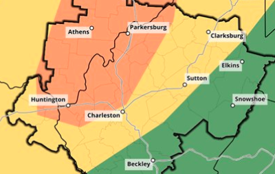
After experiencing tornadoes and widespread power outages last week, much of central and southern West Virginia is under a Hazardous Weather Outlook for Thursday, according to the National Weather Service in Charleston.
Look for showers and possibly severe thunderstorms, damaging winds and tornadoes being the primary hazards this afternoon. Localized flooding of streams and creeks could follow.
The most severe weather is expected after 1 p.m., according to the NWS, with a high of 80 this afternoon before the strongest storms blow through as temperatures drop almost 30 degrees.
The NWS predicts an enhanced risk for severe weather for an area from Huntington northeast through Parkersburg and as far east as Charleston.
Strong winds on Friday could follow, bringing down power lines.
According to the NWS, there will be showers and thunderstorms before 2 a.m. Friday, then a slight chance of showers between 2 a.m. and 4 a.m. Some of the storms could produce heavy rain.
The Huntington area is forecast to receive ¾ to an 1½ of rain from these storms. The Ohio River is not forecast to flood at this time, but areas further south and east of Huntington, heading toward Charleston, are most at risk of flooding.
Wind gusts in Huntington on Friday could be up to 31 mph.
“We could have some training thunderstorms. So wherever those set up certainly could have issues. It's kind of hard to predict that too far in advance. But with any training thunderstorms, there's always that threat,” said Gabe Wawrin, a meteorologist with the NWS in Charleston.
Update: Severe Weather Outlook remains the same, except a slight risk for excessive rainfall has been introduced across portions of the mountains, northern WV, and southeast OH. Also attached are the outlooks for greatest wind and tornado risks.#wvwx#OHwx#KYWX#VAWXpic.twitter.com/FASXAwSK9I
Keep it Clean. Please avoid obscene, vulgar, lewd,
racist or sexually-oriented language. PLEASE TURN OFF YOUR CAPS LOCK. Don't Threaten. Threats of harming another
person will not be tolerated. Be Truthful. Don't knowingly lie about anyone
or anything. Be Nice. No racism, sexism or any sort of -ism
that is degrading to another person. Be Proactive. Use the 'Report' link on
each comment to let us know of abusive posts. Share with Us. We'd love to hear eyewitness
accounts, the history behind an article.