


New maps released by the state last week illustrate likely tsunami impacts to shoreline and waterfront areas in the Anacortes area if a magnitude 9 earthquake were to hit the region.
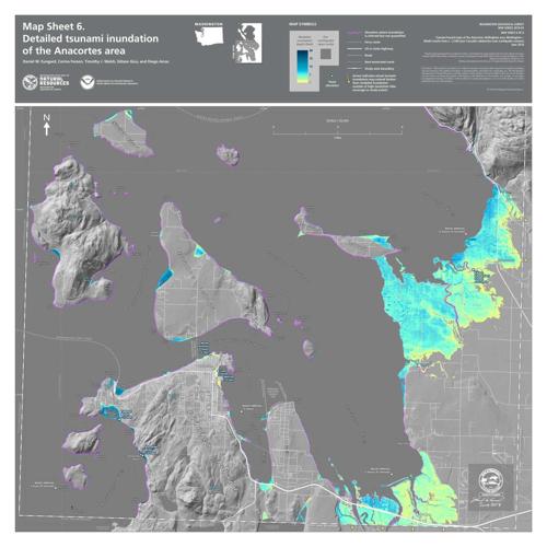
The first wave is expected to reach Anacortes about two hours after the earthquake, with widespread flooding in low-lying tidal areas near the Highway 20 bridge into Anacortes, and deeper inundation — an estimated 10 to 15 feet — on Guemes Island and Fidalgo Island’s west shore, including Skyline Marina and Ship Harbor, according to the maps.
kAm%96 >2AD H6C6 AC6A2C65 3J E96 DE2E6 s6A2CE>6?E @7 }2EFC2= #6D@FC46D’D (2D9:?8E@? v6@=@8:42= $FCG6J 5:G:D:@? E@ 96=A 4@>>F?:E:6D AC6A2C6 7@C 5:D2DE6CD :? E96 6G6?E @7 2 =2C86 62CE9BF2<6 @? E96 k2 9C67lQ9EEADi^^A?D?]@C8^@FEC6249^62CE9BF2<6D@FC46D^4DKQ E2C86ElQ03=2?<Qmr2D425:2 $F35F4E:@? +@?6k^2m]k^Am
kAm“t2CE9BF2<6D 2?5 EDF?2>:D 2C6 G6CJ C62= E9C62ED E92E H6 >FDE 36 AC@24E:G6 :? AC6A2C:?8 7@C[” D2:5 r@>>:DD:@?6C @7 !F3=:4 {2?5D w:=2CJ uC2?K :? 2 ?6HD C6=62D6]k^Am
kAm$<28:E r@F?EJ 2?5 E96 r:EJ @7 p?24@CE6D 2C6 3@E9 >2<:?8 492?86D E@ E96:C 6>6C86?4J C6DA@?D6 A=2??:?8 32D65 @? E96 ?6H >2AD]k^Am
kAm!C6G:@FD >2AD 4C62E65 :? a__d 7@C E96 p?24@CE6D 2C62 D9@H EDF?2>: :>A24ED 27E6C E96 d__\J62C r2D425:2 62CE9BF2<6[ 2? 6G6?E =:<6=J E@ @44FC 6G6CJ d__ J62CD] (:E9 E96 ?6H >2AD[ E96 DE2E6 =@@<65 2E E96 a[d__\J62C D46?2C:@[ D2:5 pDD:DE2?E $E2E6 v6@=@8:DE %:> (2=D9]k^Am
kAm“xE’D 2 =6DD =:<6=J D46?2C:@ @7 2 =2C86C 6G6?E[” 96 D2:5]k^Am
kAm(9:=6 :E’D A@DD:3=6 2? 6G6? H@CD6 62CE9BF2<6 4@F=5 9:E — E96 `_[___\J62C 6G6?E — E96 ?6H EDF?2>: >@56=D 2=:8? H:E9 4FCC6?E 3F:=5:?8 4@56D 7@C 62CE9BF2<6 C6D:=:6?4J C6BF:C65 7@C 4C:E:42= 724:=:E:6D[ DF49 2D 9@DA:E2=D[ (2=D9 D2:5]k^Am
kAmv6@=@8:42= 6G:56?46 @7 EDF?2>:D 2EEC:3FE65 E@ r2D425:2 62CE9BF2<6D 92D 366? 7@F?5 2E D:E6D @? E96 (6DE r@2DE[ @? 3@E9 E96 @FE6C 4@2DED 2?5 :?=2?5 !F86E $@F?5[ 244@C5:?8 E@ E96 DEF5J] #6D62C496CD 36=:6G6 `f__ H2D E96 =2DE E:>6 2 r2D425:2 62CE9BF2<6 DECF4<[ H:E9 EDF?2>: H2G6D @3D6CG65 :? y2A2?]k^Am
kAm%96 r$+ :D 2 ea`\>:=6 =@?8 72F=E E92E DEC6E496D 7C@> ?@CE96C? '2?4@FG6C xD=2?5 E@ }@CE96C? r2=:7@C?:2 H96C6 E96 yF2? 56 uF42 !=2E6 :D >@G:?8 F?56C E96 }@CE9 p>6C:42? !=2E6[ 244@C5:?8 E@ E96 !24:7:4 }@CE9H6DE $6:D>:4 }6EH@C<] (96? E9:D 72F=E CFAEFC6D[ :E >2J 42FD6 2 “>682E9CFDE” 62CE9BF2<6 — E96 t2CE9’D =2C86DE <:?5]k^Am
kAmx? p?24@CE6D[ 27E6C D6G6C2= >:?FE6D @7 D92<:?8[ E96 7:CDE D:8? @7 2? :?4@>:?8 EDF?2>: H:== 36 2 8C25F2= 5C@A :? H2E6C =6G6=[ H:E9 E96 7:CDE H2G6 9:EE:?8 23@FE EH@ 9@FCD =2E6C[ 244@C5:?8 E@ E96 DEF5J] %96 D64@?5 H2G6[ E9C66 9@FCD 27E6C E96 62CE9BF2<6[ :D 6IA64E65 E@ 36 E96 E2==6DE[ 2? 6DE:>2E65 e]h 766E 2E E96 6?EC2?46 E@ u:52=8@ q2J]k^Am
kAm$>2==6C H2G6D F?56C d 766E 2C6 6IA64E65 E@ 4@?E:?F6 7@C 2E =62DE 6:89E 9@FCD]k^Am
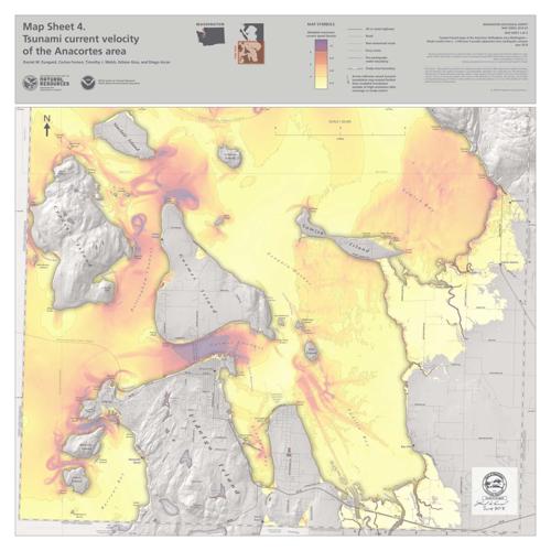
kAmq@2ED 2?5 D9:AD @? E96 H2E6C 2=D@ 7246 E9C62ED 7C@> 2 EDF?2>:[ H:E9 DEC@?8 4FCC6?ED =2DE:?8 7@C ac 9@FCD] %96 72DE6DE 4FCC6?ED 2C6 6IA64E65 :? vF6>6D r92??6= 2?5 @77 qFCC@HD xD=2?5[ 244@C5:?8 E@ 2 D6A2C2E6 >2A E92E D9@HD 4FCC6?E DA665D :? :?4C6>6?ED @7 E9C66 <?@ED]k^Am
kAm“x7 E96 EDF?2>: 4@>6D H96? 2 3@2E :D 2=C625J :? H2E6C[ WE96 >2AX H:== 8:G6 D@>6 8F:52?46 2D H96C6 E@ 8@ E@ 86E E@ =@H6C 4FCC6?ED[” (2=D9 D2:5]k^Am
kAmx?F?52E:@? 56AE9D @? E96 >2A 92G6 C62=\=:76 D276EJ :>A=:42E:@?D[ (2=D9 D2:5] !6@A=6 F?23=6 E@ 6G24F2E6 >2J 36 23=6 E@ 9:56 :?D:56 @C @? E@A @7 2 3F:=5:?8 :? H2E6C F?56C e 766E 566A E@ DFCG:G6] qFE :? H2E6C @G6C e 766E[ DFCG:G2= :D 9:89=J F?=:<6=J[ 244@C5:?8 E@ E96 DEF5J]k^Am
kAm$<28:E r@F?EJ s6A2CE>6?E @7 t>6C86?4J |2?286>6?E[ E96 r:EJ @7 p?24@CE6D 2?5 DE2E6 2C6 H@C<:?8 E@ :56?E:7J 56D:8?2E65 2DD6>3=J D:E6D :? 9:89[ 5CJ 2C62D H96C6 C6D:56?ED 42? H2=< E@ 5FC:?8 2 EDF?2>: E9C62E[ H:E9 E96 2DDF>AE:@? E92E C@25D 2?5 3C:586D H:== 36 @FE @7 D6CG:46[ D2:5 s@F8=2D E6? w@@A6?[ 5:C64E@C @7 6>6C86?4J >2?286>6?E 7@C E96 4@F?EJ]k^Am
kAm“%96 8@@5 ?6HD :D E92E E96 =625 E:>6 7@C H96? 2 EDF?2>: H@F=5 9:E p?24@CE6D H@F=5 36 H6== @G6C 2? 9@FC\2?5\2\92=7[” 96 D2:5] %92E 8:G6D C6D:56?ED E:>6 E@ 86E E@ 2? 2DD6>3=J 2C62[ >@DE @7 H9:49 H:== 36 ?@ >@C6 E92? 2 a_\>:?FE6 H2=<[ 32D65 @? E96 ?2E:@?2= 2G6C286 H2=<:?8 DA665 @7 23@FE ac >:?FE6D A6C >:=6[ 96 D2:5]k^Am
kAmpDD6>3=J 2C62D[ H9:49 >2J 36 =@42E65 2E @A6? 2C62D DF49 2D A2C<:?8 =@ED @C 7:6=5D[ 2C6 ?@E 56D:8?65 E@ 36 D96=E6CD[ D@ C6D:56?ED D9@F=5 5C6DD 7@C E96 H62E96C[ 96 D2:5]k^Am
kAm“%96C6’D 2DDF>AE:@? E92E :7 E96C6’D 2 3:8 62CE9BF2<6[ E96C6’D ?@ 8F2C2?E66 J@F 42? 8@ :?D:56 E96D6 3F:=5:?8D[” 96 D2:5]k^Am
kAm%96 D:E6D H:== 36 5:DA=2J65 @? >2AD 2?5 >256 2G2:=23=6 E@ E96 AF3=:4 2E 2 =2E6C E:>6]k^Am
kAmk2 9C67lQ9EEADi^^HHH]C625J]8@G^3F:=5\2\<:EQ E2C86ElQ03=2?<Qm#625J]8@Gk^2m C64@>>6?5D 6249 A6CD@? 92G6 2 82==@? @7 H2E6C 2 52J 7@C 5C:?<:?8 2?5 32E9:?8[ 2 E9C66\52J DFAA=J @7 ?@?A6C:D923=6 7@@5[ 2 7:CDE 2:5 <:E[ :>A@CE2?E >65:42E:@?D 2?5 >@C6]k^Am
kAm“w2G6 2 8@\328 C625J E92E J@F 42? 8C23[” E6? w@@A6? D2:5]k^Am
kAm#6D:56?ED 42? D:8? FA @? E96 4@F?EJ’D H63D:E6 E@ C646:G6 p=6CE$6?D6 6>6C86?4J 2=6CED 7@C E96:C 2C62]k^Am
kAm(9:=6 p?24@CE6D 5@6D ?@E 92G6 2?J EDF?2>: H2C?:?8 D:C6?D C:89E ?@H[ $<28:E r@F?EJ :D @? E96 =:DE E@ C646:G6 D6G6C2= 7C@> E96 DE2E6 H96? 7F?5D 364@>6 2G2:=23=6[ E6? w@@A6? D2:5]k^Am
kAmp?24@CE6D u:C6 r9:67 #:492C5 rFCE:D D2:5 E96 4:EJ :D 255:?8 `d A6C46?E >@C6 3F776C K@?6 E@ E96 C6G:D65 :?F?52E:@? 2C62D D9@H? @? E96 >2AD]k^Am
kAm“xE’D 2 `d A6C46?E >2C8:? @7 D276EJ :?4C62D6[” 96 D2:5]k^Am
kAm%96 4:EJ :D 2=D@ H@C<:?8 @? 2 C6G6CD6 h`` DJDE6> 42==65 r@56#ts E@ 86E :?7@C>2E:@? E@ C6D:56?ED :? :?F?52E:@? 2C62D[ rFCE:D D2:5]k^Am
kAmx? E96 >62?E:>6[ C6D:56?ED D9@F=5 72>:=:2C:K6 E96>D6=G6D H:E9 5:D2DE6CD =:<6=J :? E96:C C68:@? 2?5 H@C< @? AC6A2C65?6DD[ 96 D2:5]k^Am
kAm“tG6CJ3@5J ?665D E@ 36 23=6 E@ E2<6 42C6 @7 E96>D6=G6D :? 2== E9@D6 4:C4F>DE2?46D[” 96 D2:5]k^Am


(0) comments
Welcome to the discussion.
Log In
Keep it Clean. Please avoid obscene, vulgar, lewd, racist or sexually-oriented language.
PLEASE TURN OFF YOUR CAPS LOCK.
Don't Threaten. Threats of harming another person will not be tolerated.
Be Truthful. Don't knowingly lie about anyone or anything.
Be Nice. No racism, sexism or any sort of -ism that is degrading to another person.
Be Proactive. Use the 'Report' link on each comment to let us know of abusive posts.
Share with Us. We'd love to hear eyewitness accounts, the history behind an article.