Illinois Bike Summit included updates on projects in Logan, Big Marsh, downstate
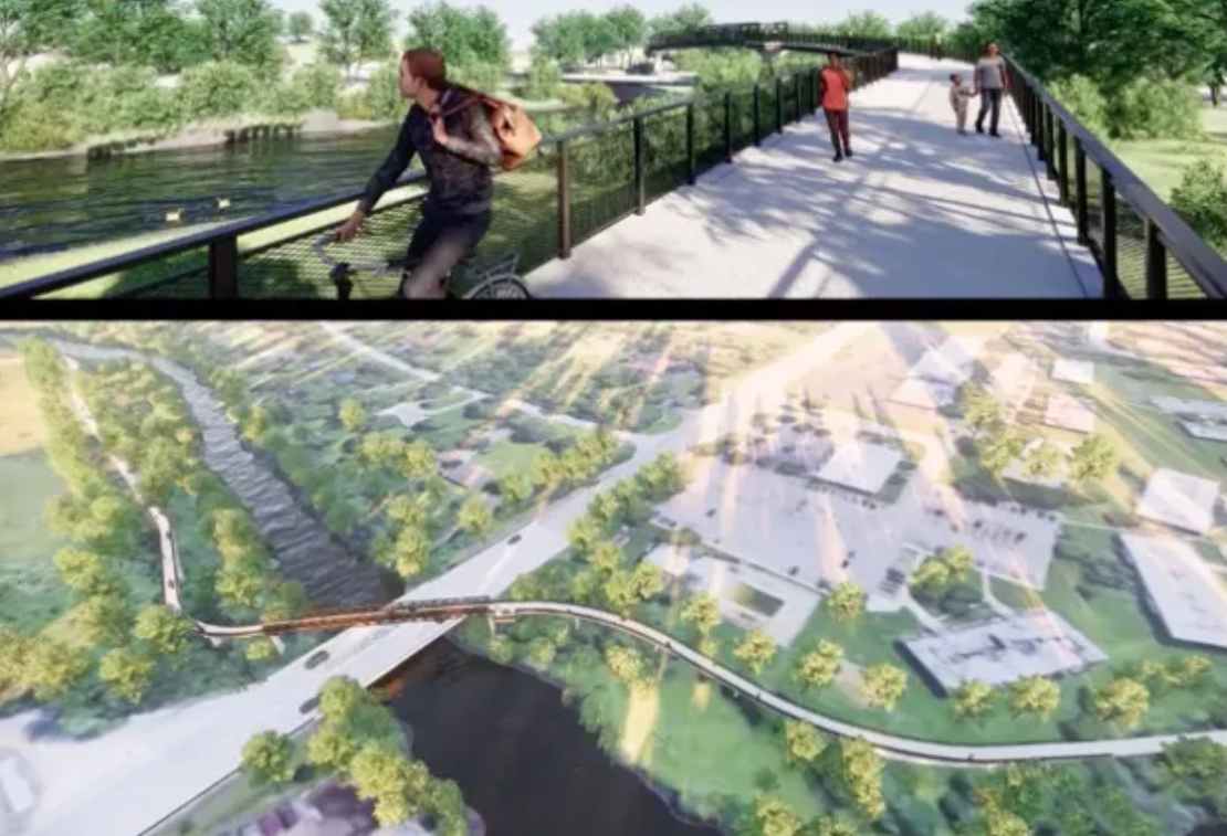
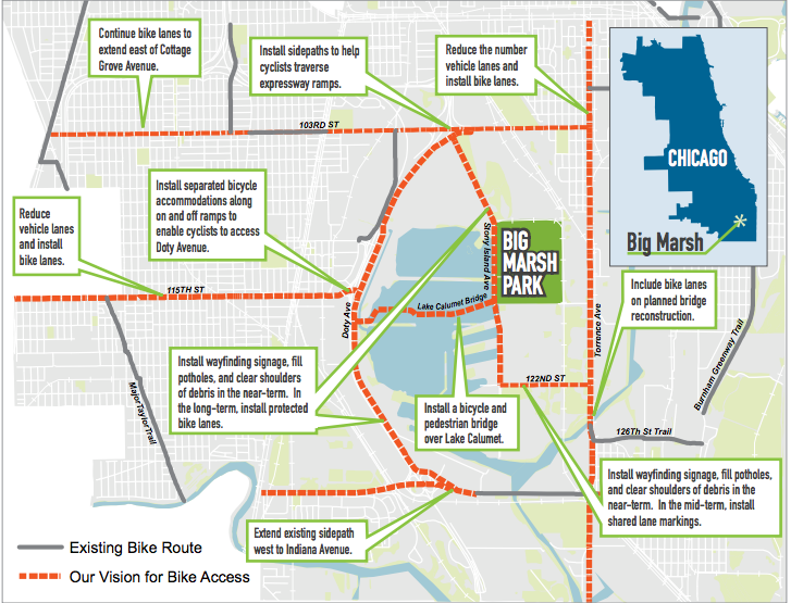
Rendering of the planned bike bridge across Lake Calumet to Big Marsh bike park.
The Illinois Bike Summit, an annual gathering of bike planners, advocates, shop owners, and enthusiasts, took place virtually Tuesday with the theme of infrastructure, education and inclusion, including breakout sessions grouped under each category.
The day opened with remarks from Bill Nesper, executive director of the League of American Bicyclists; Maulik Vaishnav, transportation policy advisor to Mayor Lori Lightfoot's office, who gave a very cursory peek into the city’s 2021 transportation plan; and state representative Theresa Mah, whose 2nd District includes Back of the Yards, Bridgeport, Brighton Park, Pilsen, Chinatown and McKinley Park. Mah talked about her efforts to get the Dutch Reach -- the anti-dooring strategy of opening a car door with your far hand, which forces you to look back towards any oncoming cyclists -- on the Illinois drivers test.
I mostly attended infrastructure-themed breakout sessions (Streetsblog's Courtney Cobbs will have more coverage of the summit tomorrow), starting with "Bikeway Types and Bike Planning" with Ride Illinois senior consultant Ed Barsotti. The session was a primer on planning and implementation, starting with a list of manuals accepted by various governing bodies, several of which were surprisingly out of date. For instance, the “current” edition of "Guide for the Development of Bicycle Facilities" from the American Association of State Highway and Transportation Officials -- considered the authoritative federal-level guide to building new bike infrastructure -- is from 2012, years before modern bike-share systems and dockless electric scooters became widespread in the U.S., changing the way bike infrastructure in urban centers is used. Barsotti said that the Illinois Department of Transportation’s roadway manuals (from the Bureau of Design and Environment and Bureau of Local Roads and Streets) have also lagged badly behind national standards in the past, but are now catching up with the times.
Barsotti then gave an overview of different on- and off-road bikeways: how they function and which is most appropriate in what situation. For example, off-street side paths are most appropriate next to high-speed roads with few intersections. Sharrows -- shared lanes marked by bike-and-chevron symbols -- are a last resort when there is deemed to be insufficient room for a bike lane on a low-speed, urban roadway.
Barsotti then gave a rough cost range per mile to implement each bikeway type, and broad strategies for the planning and implementation of projects. He discussed the importance of involving residents in the planning process, incorporating plans where possible into ordinances and other road projects, and of course, heading off Not In My Back Yard-style opposition. I found some of the wonkiest aspects of his presentation to be the most interesting. For instance, the Ride Illinois website has a Bicycle Level of Service calculator that takes a bunch of road metrics -- traffic density, width of shoulder, speed limit, heavy vehicle traffic, pavement condition, etc. -- and churns out a rating of how comfortable most adults would be biking under those circumstances. After the summit, I spent a good hour plugging in my best guesses of BLOS data points for about two dozen streets I regularly ride.
After lunch, I attended the "Infrastructure Case Studies" seminar, which gave an overview of four projects: CDOT’s recent expansion of bikeways in the city, design plans for a Chicago River Trail to span Lake Calumet and connect the Pullman neighborhood with Big Marsh Park, Champaign-Urbana’s impressive MCORE project, and a new pump track in Shelbyville. David Smith, CDOT’s bicycle and pedestrian program manager talked about recent improvements to bike infrastructure in Chicago: 30 miles of new bikeways installed this year, the addition of hundreds of desperately needed (and long overdue) bike racks, the expansion of Divvy stations to the Far South Side and the introduction of electric Divvies.
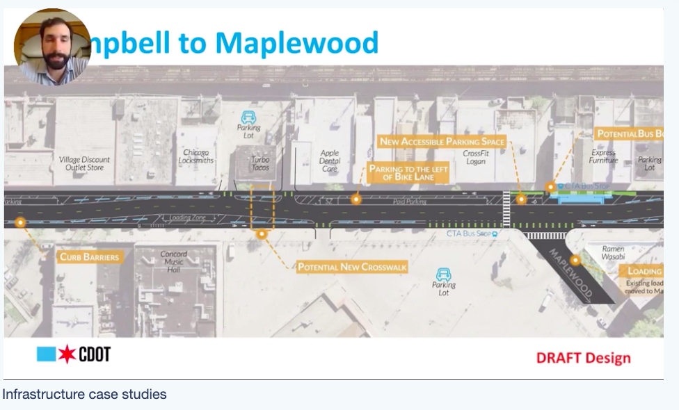
Quite a bit of the presentation focused on a project that broke ground Monday, improving the stretch of Milwaukee Avenue between Western and California avenues in Logan Square. Car parking will be consolidated to the north side of the street and relocated to the left of the northwest-bound bike lane to provide physical protection. On the south side of the street, plastic curbs will be installed to create a southeast-bound protected bike lane. The project also includes additional crosswalks with wheelchair ramps.
Tim Gustafson, a senior planner at the architecture firm Epstein, talked through the considerations that go into designing a section of the Chicago River Trail slated to span Lake Calumet. Flooding, a common problem on fixed paths like the downtown Chicago Riverwalk when water levels rise in the spring, is a big concern for the new trail. A floating trail, which eliminates the flooding issue and has less negative environmental impact, seems like the solution. Now designers are looking to the 31st street floating harbor as inspiration for how to build a floating path sturdy enough for bike traffic. Other concerns include the grade of the trail and accessibility for users in wheelchairs, and how to protect cyclists and pedestrians from errant golf balls from the nearby Harborside International Golf Center. The design process for the trail continues, and no completion date was announced.
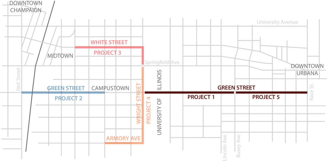
While I was mostly interested in hearing about Chicago-based projects, a presentation on the MCORE (Multimodal Corridor Enhancement) project in Champaign-Urbana was truly inspiring. A $15 million federal grant funded a five-part project that transformed biking and transit in the area. Ryan Hughes, Transportation Engineer at Clark Dietz, an engineering firm for the project, talked through the plan from the perspective of how it changed his own daily bike commute from Urbana to downtown Champaign. Green Street, a major east-west thoroughfare and the heart of the University of Illinois campus, was streetscaped in multiple phases to become a bike-friendly route between the cities. The section of Green Street in the heart of campus was reimagined to safely accommodate heavy foot, bike, and bus traffic with island transit platforms protecting green-pained bike lanes, similar to the layout of the Washington Street section of Chicago's Loop Link corridor.
The final presentation was given by Jerry Yockey, chair of General Dacey Trail in Shelbyville, Illinois, located about 70 miles southwest of Champaign-Urbana. Yockey is a volunteer who helped organize the construction of a pump track near the trail. (A pump track is a circuit that vertically ripples in such a way that cyclists can build up enough speed going down each roller to crest the next incline, biking around the track by applying force to the handlebars, with no pedaling required.) Yockey said the track is a huge hit with kids and easy enough for even small children and novice cyclists to ride with any type of bike. Here in Chicago, there are pump tracks in Big Marsh and Clark Park (the latter is called "The Garden.")
While the infrastructure improvements in Chicago over the last year, particularly the new bikeways and bike-share stations on the South Side, are steps in the right direction, investments in dedicated bus lanes and an annual Safe Streets Fund to walk/bike infrastructure, focused on high-crash corridors in underserved communities, are needed to address transportation inequities that have been exacerbated by the pandemic. It’s not too late to contact your alderman to express support for Active Transportation Alliance’s 2021 funding priorities, and your congressional representatives to voice support for transit emergency funds to be included in the next federal relief bill.
Stay in touch
Sign up for our free newsletter
More from Streetsblog Chicago
Today’s Headlines for Thursday, April 26

The de-facto ban on riverwalk biking is back. What should we do about it?
In the short term, new signage is needed to designate legal areas for cycling on the path. In the long term CDOT should build the proposed Wacker Drive protected bike lane.